Climate Science Glossary

Term Lookup

Enter a term in the search box to find its definition.

Settings

Use the controls in the far right panel to increase or decrease the number of terms automatically displayed (or to completely turn that feature off).

Term Lookup

Settings


All IPCC definitions taken from Climate Change 2007: The Physical Science Basis. Working Group I Contribution to the Fourth Assessment Report of the Intergovernmental Panel on Climate Change, Annex I, Glossary, pp. 941-954. Cambridge University Press.

Home Arguments Software Resources Comments The Consensus Project Translations About Support

Twitter Facebook YouTube Mastodon MeWe

RSS Posts RSS Comments Email Subscribe


Climate's changed before
It's the sun
It's not bad
There is no consensus
It's cooling
Models are unreliable
Temp record is unreliable
Animals and plants can adapt
It hasn't warmed since 1998
Antarctica is gaining ice
View All Arguments...


Username
Password
New? Register here
Forgot your password?

Latest Posts

Archives

What is the link between hurricanes and global warming?

What the science says...

Select a level... Basic Intermediate

There is increasing evidence that hurricanes are getting stronger due to global warming.

Climate Myth...

Hurricanes aren't linked to global warming

“According to the National Hurricane Center, storms are no more intense or frequent worldwide than they have been since 1850. […] Constant 24-7 media coverage of every significant storm worldwide just makes it seem that way.” (Paul Bedard)

The current research into the effects of climate change on tropical storms demonstrates not only the virtues and transparency of the scientific method at work, but rebuts the frequent suggestion that scientists fit their findings to a pre-determined agenda in support of climate change. In the case of storm frequency, there is no consensus and reputable scientists have two diametrically opposed theories about increasing frequencies of such events.

The background to these enquiries stems from a simple observation: extra heat in the air or the oceans is a form of energy, and storms are driven by such energy. What we do not know is whether we might see more storms as a result of extra energy or, as other researchers believe, the storms may grow more intense, but the number might actually diminish.

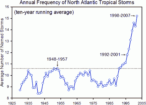
What do the records show? When this rebuttal was first published in 2010, the Pew Centre stated, “Globally, there is an average of about 90 tropical storms a year”. The IPCC AR4 report (2007) says regarding global tropical storms: "There is no clear trend in the annual numbers [i.e. frequency] of tropical cyclones."

But this graph, also from the Pew Centre, shows a 40% increase in North Atlantic tropical storms over the historic maximum of the mid-1950, which at the time was considered extreme:

But while the numbers are not contested, their significance most certainly is. Another study considered how this information was being collected, and research suggested that the increase in reported storms was due to improved monitoring rather than more storms actually taking place.

And to cap it off, two recent peer-reviewed studies completely contradict each other. One paper predicts considerably more storms due to global warming. Another paper suggests the exact opposite – that there will be fewer storms in the future.

What can we conclude from these studies? About hurricane frequency – not much; the jury is out, as they say. About climate change, we can say that these differing approaches are the very stuff of good science, and the science clearly isn’t settled! It is also obvious that researchers are not shying away from refuting associations with climate change, so we can assume they don’t think their funding or salaries are jeopardised by research they believe fails to support the case for AGW. The scientific method is alive and well.

Never mind the frequency, feel the width

So far, all we’ve managed is to document here is what we don’t know for sure yet. But we do know there is extra energy in the system now, so could it have any other effects on tropical storms? Here, the science is far less equivocal, and there is a broad consensus that storms are increasing in strength, or severity. This attribute, called the Power Dissipation Index, measures the duration and intensity (wind speed) of storms, and research has found that since the mid-1970s, there has been an increase in the energy of storms.

Recent research has shown that we are experiencing more storms with higher wind speeds, and these storms will be more destructive, last longer and make landfall more frequently than in the past. Because this phenomenon is strongly associated with sea surface temperatures, it is reasonable to suggest a strong probability that the increase in storm intensity and climate change are linked.

Basic rebuttal written by GPWayne


Update July 2015:

Here is a related lecture-video from Denial101x - Making Sense of Climate Science Denial


This rebuttal was updated by Judith Matz in September 2021 to replace broken links. The updates are a result of our call for help published in May 2021.

Last updated on 5 July 2015 by pattimer. View Archives

Printable Version  |  Offline PDF Version  |  Link to this page

Argument Feedback

Please use this form to let us know about suggested updates to this rebuttal.

Acknowledgements

The image North Atlantic Tropical Storms and Observing Techniques is courtesy of Global Warming Art.

Emanuel's graph of PDI versus temperature was courtesy of Climate 411.

Further reading

Comments

Prev  1  2  3  Next

Comments 26 to 50 out of 71:

  1. #26 muoncounter at 13:48 PM on 21 January, 2011 But here's how the folks who gather the Accumulated Cyclone Energy data forecast the 2010 storm season I don't think it does much good to your cause to cherry pick an old North Atlantic ACE forecast for 2010 when we are already well into 2011, so we have got facts. According to them, North Atlantic ACE was indeed somewhat above average, even if at the lower end of the forecast you have cited. More importantly, we are talking about global warming here, not about some North Atlantic Warming. And global ACE for 2010 was way below average, close to an all time low.
  2. #28: "North Atlantic ACE was indeed somewhat above average, even if at the lower end of the forecast" Great! I'll alert the National Hurricane Center to stand down. Large-scale climate features strongly influenced this year’s hurricane activity, as they often do. This year, record warm Atlantic waters, combined with the favorable winds coming off Africa and weak wind shear aided by La Niña energized developing storms. The 2010 season continues the string of active hurricane seasons that began in 1995. But short-term weather patterns dictate where storms actually travel and in many cases this season, that was away from the United States. The jet stream’s position contributed to warm and dry conditions in the eastern U.S. and acted as a barrier that kept many storms over open water. Also, because many storms formed in the extreme eastern Atlantic, they re-curved back out to sea without threatening land. The alleged cherrypick of using just the Atlantic (a big cherry, that one) was initially your move. As we've said, this question isn't a settled one; no one even knows the proper metric to use.
  3. BP @28, "According to them, North Atlantic ACE was indeed somewhat above average," Oh come now, that is a demonstrably false statement BP. This is what the NHC had to say: "According to NOAA the 2010 Atlantic hurricane season, which ends tomorrow, was one of the busiest on record. In contrast, the eastern North Pacific season had the fewest storms on record since the satellite era began. In the Atlantic Basin a total of 19 named storms formed – tied with 1887 and 1995 for third highest on record. Of those, 12 became hurricanes – tied with 1969 for second highest on record. Five of those reached major hurricane status of Category 3 or higher. From Dr. Jeff Masters' blog: "This year's Accumulated Cyclone Energy (ACE) index was 163, putting it in 13th place for ACE since 1944. A "hyperactive" hurricane season is considered to have an ACE index of >175% of the median. According to Wikipedia, median ACE measured over the period 1951–2000 for the Atlantic basin was 87.5, so 2010 is a hyperactive year by that definition (183% of the median.)" Professor Maue at FSU obtained an ACE of 170 for the N. Atlantic in 2010, the 11th highest since 1950, and highest since 2005. Please retract your erroneous statement BP.
  4. #29 muoncounter at 06:54 AM on 29 January, 2011 Great! I'll alert the National Hurricane Center to stand down. Good idea. Their prediction in August 2010 for annual North Atlantic ACE was between 148×104 kt2 & 236 ×104 kt2. The actual figure is something like 163-170 (if we go with Dr. Jeff Masters or Dr. Ryan N. Maue). That's in the lower quarter of the forecast, i.e. close to the lower end of it. But the real insult is that the National Hurricane Center of the U.S. of A. still does not have the facts for 2010, although the year is somewhat over. The alleged cherrypick of using just the Atlantic (a big cherry, that one) was initially your move. Sit down please, you have not listened. That one is accumulated intensity of hurricanes making landfall in the US since 1863. It just puts things into historical perspective and the US was chosen only because old hurricanes there are well documented. It has nothing to do with North Atlantic ACE (as 2010 clearly shows). Here and now we are talking about the satellite era, for which we have pretty accurate global estimate for ACE including tropical storms that do not make landfall anywhere. And no, the North Atlantic is not a big cherry, it's less than 8% of the surface of the globe. As I have said, global ACE for 2010 was low. My scatterplot above is also for global ACE and as such, it is meaningful indeed.
  5. BP @31, OK, still waiting for your to acknowledge and retract your erroneous statement made at 28 which I pointed out at 30. "But the real insult is that the National Hurricane Center of the U.S. of A. still does not have the facts for 2010, although the year is somewhat over." Enough with the juvenile insults from you BP. "Sit down please, you have not listened." And again with the juvenile insults from you BP. In fact, I would argue that your post @30 breaks the house rules. Moderator? I'll address the issue with your scatterplot in another post.
  6. BP: Do I understand you to claim that since the Atlantic ACE was at the lower end of an extraordinarily high prediction that means it was low? Albatross has cited data that show the Atlantic ACE was high in 2010 and you need to admit that. Your claiming that we should rely on a tiny percentage of the data (USA landfalling hurricanes) instead of the entire record is unscientific. The remainder of the hurricane record is not as bad as you claim. You need to drop this claim as it hurts what is left of your reputation.
  7. BP @31, "But the real insult is that the National Hurricane Center of the U.S. of A. still does not have the facts for 2010, although the year is somewhat over." Sigh, read this, issued on 29 November 2010.
  8. BP @31, "My scatterplot above is also for global ACE and as such, it is meaningful indeed." Well, you are entitled to your opinion, no matter how misguided it may be and no matter how unscientific. I can try and hook you up with Christopher Monckton if you like... As I'm sure you know, TCs are primarily a tropical phenomenon except on those occasions when they undergo extra-tropical transition. So your scatterplot might have been more "meaningful" or convincing had you looked at OHC (or SSTs) for the tropics, instead of lower-tropospheric temperatures for the globe (from a group/product with a less than reputable history).
  9. #29: "the real insult is that the National Hurricane Center ... still does not have the facts for 2010" Only can be considered an insult if true. As Albatross notes in #32, here are the facts, as of 29 Nov 2010: According to NOAA the 2010 Atlantic hurricane season, which ends tomorrow, was one of the busiest on record. In contrast, the eastern North Pacific season had the fewest storms on record since the satellite era began. In the Atlantic Basin a total of 19 named storms formed – tied with 1887 and 1995 for third highest on record. Of those, 12 became hurricanes – tied with 1969 for second highest on record. Five of those reached major hurricane status of Category 3 or higher. "Sit down please, you have not listened. That one is accumulated intensity of hurricanes making landfall in the US" Believe me, I'm not standing. As you seem to not recognize it, you picked only hurricanes (ignoring tropical storms) and only US landfalls; by comparison to that cherry pittance, the Atlantic basin looms large. "My scatterplot above ... is meaningful indeed. " If, by 'meaning,' you find some hidden significance in a shotgun spread of data points. See #24 for the way you described it. The ACE statistic is a wind speed-time duration metric. By focusing on this alone, you miss what is suggested here. Hurricane Tomas brought heavy rain to earthquake-ravaged Haiti, and several storms, including Alex, battered eastern Mexico and Central America with heavy rain, mudslides and deadly flooding. Alex was cat 2 at landfall (ACE 7.7); Tomas varied from TS to cat 1 (ACE 10.9). By comparsion, Igor was cat 4 (ACE 42.4), all as reported here. These storms are doing more damage because of they are associated with heavy 'predecessor rain events' (PREs), as tropical moisture is pulled along the storm track, as reported by Galarneau et al 2010: PREs are coherent mesoscale regions of heavy rainfall, ... that can occur approximately 1000 km poleward of recurving tropical cyclones (TCs). PREs occur most commonly in August and September, and approximately 36 h prior to the arrival of the main rain shield associated with the TC. ... PREs are high-impact weather events that can often result in significant inland flooding, either from the PRE itself or from the subsequent arrival of the main rain shield associated with the TC that falls onto soils already saturated by the PRE. A more comprehensive and sobering picture of storm effects is given in an unpublished piece by Drews 2007, who presents a breakdown of the ACE index into the components illustrated below. As I said twice now, perhaps we can agree that this question remains open. It is tedious in the extreme to be overly dogmatic when it is clear that a better metric is needed.
  10. BP #29 Your scatterplot is rather meaningless - for complex emergent phenomena like hurricanes, a simple univeriate analysis like your scatterplot is meaningless in the extreme, as hurricanes are complex and multidimensional entities, from an analytic perspective.
  11. regarding the graph @18 Global Tropical Cyclone Accumulated Cyclone Energy (ACE) according to Dr. Ryan N. Maue at the Florida State University: I was disappointed that no one addressed Maue's work and using Atlantic ocean stats does little to address his claim regarding Northern Hemisphere being at a 30 year ACE low. Any insights would be appreciated.
  12. #36: "no one addressed Maue's work" See #34 and links therein.
  13. MC, OK I've gone through it again with more care and I've look at some of the links below but am as confused as ever about the various claims. In particular, when someone waves that The FSU graph at #18: "Global Tropical Cyclone Accumulated Cyclone Energy" graph in one's face. Why no trend? Because Maue lumped all cyclones together and would have come up with something very different if he looked at just category 4, 5 storms? (is such a chart available?) And if one does that, what about being charged with cherry picking?
  14. citizenschallenge, I think the problem may be that ACE blends wind speed and storm duration, as seen here in Bell et al 2000: ... accumulating Vmax^2 for all 6-hourly periods in which the system is either a tropical storm or hurricane, thereby also accounting for the number and duration of storms while at a tropical storm status. This modified HDP index is referred to as accumulated cyclone energy (ACE) index, and is both a physically and statistically reasonable measure of overall activity during a given hurricane season. This was a modification of 'hurricane destructive potential (HDP),' which was originated by William Gray in 1987. As a wind speed-duration index, ACE neglects rainfall. As we associate increasing sea surface temperature with more intense precipitation events, it is not unreasonable that ACE appears to have little or no trend. For example, Fran (1996, cat 3) has a higher ACE (26) than Katrina (2005, cat 5, ACE 20). Though lower in windspeed, Fran became a TS while well out in the Atlantic and thus had a much longer track. (wikipedia has detailed storm season histories; ACE data are tabulated here). Without including rainfall, ACE has the potential to misstate the energy redistribution taking place during a hurricane by a large amount: The rate of energy release for each mm/hour of rainfall is three times as great as the solar energy (~350 Watts/m2) that falls on the same surface area. Thus the precipitation process concentrates heat that was used to evaporate moisture from large expanses of the tropics by factors of ten to a hundred into those regions where rain occurs. While solar heating of the atmosphere takes place mainly at the surface, the heat released by condensation occurs at high altitudes where it has a greater impact on the atmosphere's large scale circulation. Averaged over the entire Earth the heating released by precipitation is about five times greater than that produced by variations in surface heating.
  15. Very interesting. So the Maue graph is misleading because it is missing an important metric - rainfall(and its energy release). If that were included that graph would look much different. Thank you for info and those links.
  16. Interesting new blog post by Michael Tobis: Is there a trend in Atlantic hurricanes? Some people are still stuck in hypothesis testing mode, which I think is starting to get a little bit crazy. We can only test hypotheses that way. We cannot use that approach to establish that changing the radiative properties of the atmosphere is safe. My claim is that we need to get our thinking out of nudge-world. This is not a nudge. ... I don't understand why people don't anticipate some ringing in a system that gets kicked this hard.
  17. These papers are turning up in arguments: Sienz, F., A. Schneidereit, R. Blender, K. Fraedrich, and F. Lunkeit. 2010. Extreme value statistics for North Atlantic cyclones. Tellus A, 62, 347-360. Wallace, D.J., and J.B. Anderson. 2010. Evidence of similar probability of intense hurricane strikes for the Gulf of Mexico over the late Holocene. Geology, 38, 511-514. Comments?
    Response:

    [DB] I have already commented on those papers here.  Please also note the subsequent comments on that thread; all relevant to consider.

  18. Gypster, comments on what? Perhaps you could explain what claims are being made. The Sienz et alia paper is a model study which finds, "In the warmer climate scenario (A1BS) extreme value statistics shows an intensification for all variables." Wallace et alia is a study of the likelihood of hurricanes making landfall between 5300 and 900 years before present, not their intensity. As such, I don't immediately see anything to 'comment' on about these papers in reference to the topic of this post.
  19. @DB, thanks! (Note to web editor: Perhaps an index listing often quoted papers would be helpful, My attempts to search for information on this here weren't exactly fruitful). @CBDunkerson the first paper, for instance, is being used to argue that there has been no increase/change in weather severity. Presumably it's been taken out of context; I'm looking for some context.
  20. Looks like DB came to conclusions similar to what I posted above after skimming the two papers. With the background on what is being claimed it seems like 'skeptics' are just taking random papers on hurricanes and grossly misrepresenting what they say. Either that or they're really bad at reading comprehension.
  21. No updates on hurricanes vs climate change over the past 18 months: has the issue been settled, and what is the conclusion?
  22. #46 Manny asks for updates on hurricanes vs climate change .... The latest IPCC assessment on extreme weather, including hurricanes, is the SREX report released last month. Chapter 3, Changes in Climate Extremes and their Impacts on the Natural Physical Environment (20MB pdf) The section on tropical cyclones runs from page 158 to 163. Regarding observations, SREX differs significantly from IPCC AR4, and says (page 160): Based on research subsequent to the AR4 and Kunkel et al. (2008), which further elucidated the scope of uncertainties in the historical tropical cyclone data, the most recent assessment by the World Meteorological Organization (WMO) Expert Team on Climate Change Impacts on Tropical Cyclones (Knutson et al., 2010) concluded that it remains uncertain whether past changes in any tropical cyclone activity (frequency, intensity, rainfall)exceed the variability expected through natural causes, after accounting for changes over time in observing capabilities. The present assessment regarding observed trends in tropical cyclone activity is essentially identical to the WMO assessment (Knutson et al., 2010): there is low confidence that any observed long-term (i.e., 40 years or more) increases in tropical cyclone activity are robust, after accounting for past changes in observing capabilities. Regarding possible changes in hurricane intensity, SREX notes that there is a correlation between SST and intensity which at first glance would imply that global warming would increase hurricane intensity. But SREX then goes on to note However, there is a growing body of research suggesting that local potential intensity is controlled by the difference between local SST and spatially averaged SST in the tropics (Vecchi and Soden, 2007a; Xie et al., 2010; Ramsay and Sobel, 2011). Since increases in SST due to global warming are not expected to lead to continuously increasing SST gradients, this recent research suggests that increasing SST due to global warming, by itself, does not yet have a fully understood physical link to increasingly strong tropical cyclones. (crude translation .... both warm water and a temperature differential is needed to form and intensify hurricanes, and global warming does not necessarily increase differentials)
  23. You write: "The background to these enquiries stems from a simple observation: extra heat in the air or the oceans is a form of energy, and storms are driven by such energy. What we do not know is whether we might see more storms as a result of extra energy or, as other researchers believe, the storms may grow more intense, but the number might actually diminish." That sounds plausible, but it is wrong,as should be clear to anyone familiar with basic thermodynamics. A storm is a heat engine--it converts thermal energy into mechanical energy (in the form of winds). A heat engine that converts all the thermal energy it takes in to mechanical energy is what is known as a perpetual motion machine of the second kind. It is impossible because it violates the second law of thermodynamics (entropy), in contrast to a perpetual motion machine of the first kind, which violates the first law (energy conservation). The standard example would be a ship that needed no fuel, because it ran off the heat of the ocean. Actual heat engines absorb thermal energy from a hot source, convert some into mechanical energy, and dump the rest into a colder sink. What determines the amount of mechanical energy they get is not the temperature of the source but the temperature difference between source and sink. So simply raising the temperature of sea and air doesn't make more energy available. You need some mechanism that raises the temperature difference. Hence the argument you offer is wrong (whether the conclusion is wrong I don't know). Either you don't understand the relevant science or you are willing to misrepresent the science in order to provide a simple argument for your conclusion. Your site is supposed to be offering accurate scientific information--the fact that it makes an argument inconsistent with elementary thermodynamics is a reason not to trust other arguments it makes. Sources of information that can be trusted on politically contentious issues are rare and valuable. I'll check back in a few days to see if you are still making the same argument. If you are, you are not such a source.
  24. David Friedman The observation you are commenting on does not imply any sort of perpetual motion machine as the energy that drives the heat engine is ultimately provided externally by the sun. However global warming makes more of the Sun's energy available for the creation and intensification of storms. If the Earth were thermodynamically a closed system, then your argument would have some merit, but it isn't. I would suggest that it is a good idea to refrain from suggeting that others don't understand the science, it is generally better to adopt some humilty and assume that it is you that is wrong, and ask for an explanation of why your objection is incorrect.
  25. So, David, if a difference exists "normally," then adding more to one side of the equation wouldn't produce a greater difference? The vertical profile of GHE warming is not uniform. The lower troposphere is warming at a greater rate than the upper troposphere. According to your understanding, would that not create a greater temp difference? lower trop = 0.134 K/decade mid-trop = 0.079 K/decade tropopause = -0.011 K/decade lower strat = -0.302 K/decade That's a simplistic answer, but your response was simplistic. This is not a simple box model we're dealing with. Tropical convection doesn't occur absent of other large-scale forces (increased available water vapor, for example). I'm also thinking you didn't click on the "intermediate" tab above.

Prev  1  2  3  Next

Post a Comment

Political, off-topic or ad hominem comments will be deleted. Comments Policy...

You need to be logged in to post a comment. Login via the left margin or if you're new, register here.

Link to this page


The Consensus Project Website

THE ESCALATOR

(free to republish)


© Copyright 2024 John Cook
Home | Translations | About Us | Privacy | Contact Us