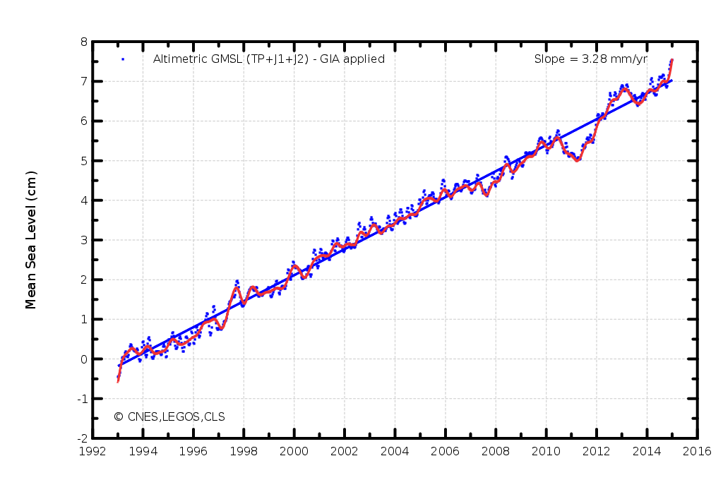
Global sea level is rising because of warming from the industrial greenhouse gas emissions we humans keep pumping into the atmosphere. The expansion of seawater as it warms, and the addition of meltwater from disintegrating land-based ice, enforce a relentless rise in sea level. Despite this ongoing rise, there are significant year-to-year fluctuations due to variations in the volume of water equivalent stored (predominantly) in the tropical land basins, and as snowfall on the gigantic ice sheets of Antarctica and Greenland.
Figure 1 - Global sea level rise from 1993-2015 as measured by satellite altimetry. The surge in sea level rise at the end of 2014 is likely to be temporary, but may signal the drying out of the major continental basins in the tropics. Image from AVISO.
As explained in the SkS sea level in 2010 rebuttal, El Niño is a time when anomalous warming occurs on the surface of the eastern tropical Pacific Ocean. This happens in response to weaker-than-normal trade winds which blow westward near the equator. Because the Coriolis Force, which typically deflects objects in motion at an angle to their path of travel, is negligible near the equator, warm water is dragged along in the same direction as the wind and piles up in the tropical western Pacific Ocean.
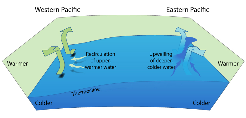
Figure 2 - Upwelling at the equator. The trade winds result in a net flow of water away from the equator due to the Coriolis Force. At the equator subsurface water is drawn up to the surface to replace it. The shallow thermocline (a result of water displacement to the west in the thin equatorial strip where the Coriolis Force drops to zero) in the east enables nutrient rich cold water from the deep to be drawn up to the surface, whereas in the west the deep thermocline results in recirculation within the layer above the thermocline. Image by jg.
Weakening of the normal trade wind strength allows the warm water in the western tropical Pacific to flow back toward the eastern Pacific in pulses known as Kelvin waves. The pattern of sea surface temperature which results, generally causes the tropical basins to dry out as rainfall is pulled away from the continents and concentrated over the oceans instead. There is a temporary spike in the rate of sea level rise as extra water is drained back into the ocean.
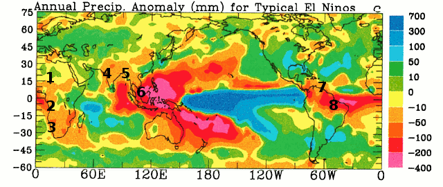
Figure 3 - Precipitation anomalies for typical El Niño (in mm). Numbers represent the 8 largest tropical river basins 1) Niger, 2) Congo, 3) Okavango, 4) Indus, 5) Ganges, 6) Mekong, 7) Orinoco, 8) Amazon. The drying of tropical continental basins temporarily raises the rate of sea level rise. Image adapted from Dai & Wigley (2000).
Strong westerly wind bursts (i.e. weak or non-existent trade winds) in early 2014 raised the spectre of a major El Niño forming in the equatorial Pacific Ocean last year. Even though a huge Kelvin wave formed in April, which implied the possibility of a significant El Niño taking shape, only a very weak El Niño appeared in late 2014. Forward to the present and we now have another Kelvin wave making its way east across the Pacific.
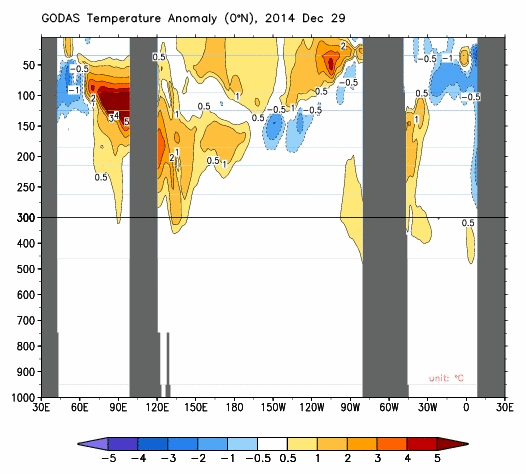
Figure 4 - A Kelvin wave makes its way eastward across the equatorial Pacific Ocean (centre frame) in response to westerly winds bursts. Note that this animation shows an anomaly - a departure from the average water temperature. The warmest temperature in the water column is still at the surface - as buoyancy would dictate. Image from NOAA's Climate Prediction Center.
Unlike the first half of 2014, when there was a strong hemispheric asymmetry as westerly wind bursts tended to be largely confined to the northern hemisphere, late 2014-early 2015 has seen a weakening in the southern hemisphere wind-driven ocean circulation too. This will have weakened the poleward transport of warm water out of the tropics and therefore diminished the ocean's capacity to drain the warm water contained in the Kelvin wave before El Niño can take hold. So it may help nudge the climate system into an El Niño state.
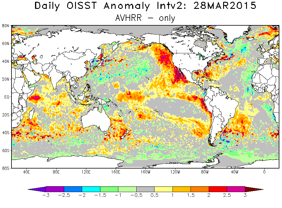
Figure 5 - Sea surface temperature anomalies suggest the emergence of the El Niño spatial pattern in the eastern tropical Pacific (a 'warm tongue'). This may strengthen as the warm water anomaly (Kelvin wave) moves along the equator toward the South American continent. OISST image from NOAA's National Climatic Data Center (NCDC).
If El Niño does form later this year, we should expect the continental basins in the tropics to dry out and the recent surge in sea level rise to continue.
Posted by Rob Painting on Tuesday, 31 March, 2015
 |
The Skeptical Science website by Skeptical Science is licensed under a Creative Commons Attribution 3.0 Unported License. |