Figure 1: UAH satellite data (red) compared to RSS satellite data (green) and surface measurements (blue). Image courtesy of Global Warming Art.
What The Science Says:
Satellite measurements match model results apart from in the tropics. There is uncertainty with the tropical data due to how various teams correct for satellite drift. The U.S. Climate Change Science Program concludes the discrepancy is most likely due to data errors.
Climate Myth: Satellites show no warming in the troposphere
"Satellite measurements indicate an absence of significant global warming since 1979, the very period that human carbon dioxide emissions have been increasing rapidly. The satellite data signal not only the absence of substantial human-induced warming but also provide an empirical test of the greenhouse hypothesis - a test that the hypothesis fails." (Bob Carter)
From 1978, a series of satellites have measured atmospheric temperature in the troposphere and stratosphere. The data is spliced together and adjusted for time-dependent biases by the University of Alabama in Huntsville (UAH), headed by John Christy and Roy Spencer. The initial results showed a warming trend of only 0.09°C per decade, well below the surface temperature trend of 0.17°C per decade. Climate models predict the troposphere should show greater warming than the surface.
In November 2005, Carl Mears and Frank Wentz at Remote Sensing Systems (RSS) performed an independent analysis of the satellite data. In the process, they found an algebraic error in the UAH analysis. With the correction made, the UAH trend was now 0.12°C per decade - larger but still less than the surface trend. However, RSS released their own results based on their data analysis - a trend of 0.19°C per decade.
Figure 1: UAH satellite data (red) compared to RSS satellite data (green) and surface measurements (blue). Image courtesy of Global Warming Art.
Part of the discrepancy between UAH and RSS was the methods used to splice the data from different satellites together. However, the major source of discrepancy was the way they corrected for diurnal drift (Mears et al 2005). The satellites orbit the earth from pole to pole. The satellites possess no propulsion so slowly over time, the local equator crossing time (LECT) changes. This is exacerbated by decay of the satellites orbital height, dragged down by the thin atmosphere. As a satellite's LECT changes, it takes readings at changing local times, allowing local diurnal cycle variations to appear as spurious trends (Christy et al 2000).
UAH and RSS employed different methods to adjust for diurnal drift and the results are radically different.
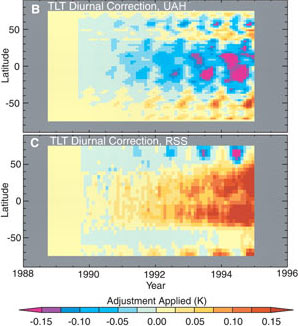
Figure 2: Diurnal drift corrections by UAH and RSS. UAH corrections add an overall cooling effect. RSS corrections added an overall warming effect. Both teams show strongest corrections in the tropics but in opposite directions.
So where does that leave us? An "Executive Summary" by the U.S. Climate Change Science Program (pdf), co-authored by John Christy of UAH concludes:
"Previously reported discrepancies between the amount of warming near the surface and higher in the atmosphere have been used to challenge the reliability of climate models and the reality of human induced global warming. This significant discrepancy no longer exists because errors in the satellite and radiosonde data have been identified and corrected. While these data are consistent with the results from climate models at the global scale, discrepancies in the tropics remain to be resolved.
This difference between models and observations may arise from errors that are common to all models, from errors in the observational data sets, or from a combination of these factors. The second explanation is favored, but the issue is still open."
In other words, according to UAH, satellite measurements match the models apart from in the tropics. This error is most likely due to data errors. According to RSS, satellites are in good agreement with models.
 |
The Skeptical Science website by Skeptical Science is licensed under a Creative Commons Attribution 3.0 Unported License. |