


 Arguments


2017 SkS Weekly Climate Change & Global Warming News Roundup #16
Posted on 22 April 2017 by John Hartz
A chronological listing of news articles posted on the Skeptical Science Facebook page during the past week. Articles of signifigance as determined by the editor are highlighted in the Editor's Picks' section.
Editor's Picks
For the first time on record, human-caused climate change has rerouted an entire river
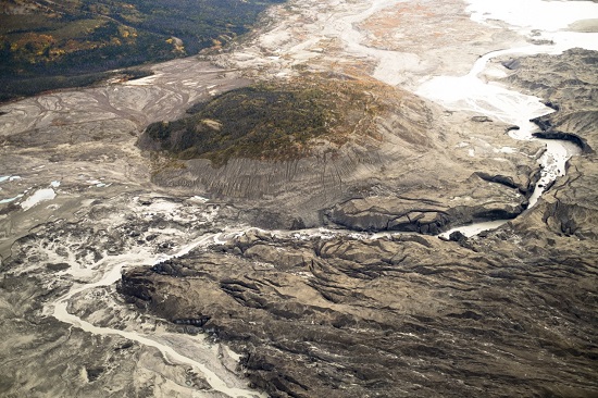
A stream flows through the toe of Kaskawulsh Glacier in Kluane National Park in the Yukon. In 2016, this channel allowed the glacier’s meltwater to drain in a different direction than normal, resulting in the Slims River water being rerouted to a different river system. (Dan Shugar)
A team of scientists on Monday documented what they’re describing as the first case of large-scale river reorganization as a result of human-caused climate change.
They found that in mid-2016, the retreat of a very large glacier in Canada’s Yukon territory led to the rerouting of its vast stream of meltwater from one river system to another — cutting down flow to the Yukon’s largest lake, and channeling freshwater to the Pacific Ocean south of Alaska, rather than to the Bering Sea.
The researchers dubbed the reorganization an act of “rapid river piracy,” saying that such events had often occurred in the Earth’s geologic past, but never before, to their knowledge, as a sudden present-day event. They also called it “geologically instantaneous.”
For the first time on record, human-caused climate change has rerouted an entire river by Chris Mooney, Energy & Environment, Washington Post, Apr 17, 2017
Climate change taking big bite out of alpine glaciers 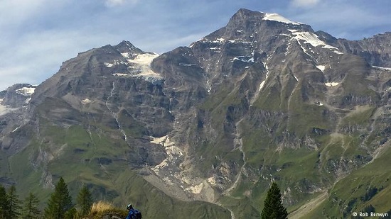
"It's almost time to say farewell to our glaciers," Austrian mountain farmer Siggi Ellmauer said, looking at the craggy summits across the Pyhrn valley. After a tour of the nature camp he's building for school kids, Ellmauer talks about how climate change is reshaping his world.
"As a child, I never would have thought they could vanish. Even 20 years ago there were still patches of ice up there on those north-facing slopes. I've watched, we've all watched the glaciers shrink here and across the country," he said.
"When will they all be completely gone?"
Climate change taking big bite out of alpine glaciers by Bob Berwyn, Deutsche Welle (DW), Apr 17, 2017
The Unfolding Tragedy of Climate Change in Bangladesh
In some places, the impact of climate change is obvious. In others, scientists predict that climate change will occur based on elaborate computer models. In Bangladesh, it is already happening at a scale that involves unprecedented human tragedy. I witnessed this in December 2016, when I visited Bangladesh to give some talks at the University of Chittagong.
December 9, 2016.“How do they survive?” I kept wondering as I walked the alleys of Old Dhaka, the capital of Bangladesh, a country with a population of 164 million on a landmass the size of New York State. People seem to be everywhere in Dhaka, in a churning frenzy of rickshaws, CNGs (Compressed Natural Gas vehicles), taxis, buses, horse-drawn carriages and people—16 million and rapidly growing. The newest arrivals, mostly climate change refugees, end up in decrepit slums.
December 18, 2016. “What will the sea do next,” I thought when I visited the remote village of Premasia, Bangladesh, at the junction of the Sangu River and the Bay of Bengal, south of Chittagong. The schoolchildren greeted us with spontaneous joyfulness, full of hope, despite the visible aftermath of Cyclone Roanu, which struck in May 2016, washing away homes and permanently ruining croplands from salt deposits. Their three-story concrete school, raised on stilts, served as a cyclone shelter during the storm. Isolated palm trees, now surrounded by water and beach, are haunting reminders that here once stood someone’s home. Rising sea levels are turning land into sea bottom, driving some people farther inland. Others rebuild repeatedly, just as Sisyphus kept pushing the rock up the hill.
December 25, 2016. “Bare rock in the high Himalayas?” I gasped as my guide Phuri Kitar Sherpa pointed out Machapuchare, also known as Fish Tail, an immense obelisk of stone perched above Pokhara, Nepal, a jumping off spot for trekkers and alpinists. A third-generation Sherpa guide, Phuri told me he rarely used to see bare stone on this holy site, now off limits to climbing and never summited. Climate change is responsible for a long-term decline in snowpack in the Himalayas, which exacerbates flooding in rivers that flow into Bangladesh.
The Unfolding Tragedy of Climate Change in Bangladesh, Guest Blog by Robert Glennon, Scientific American, Apr 21, 2017
Sun Apr 16, 2017
- NASA just snapped the first photos of a mysterious crack in one of Greenland’s largest glaciers by Chris Mooney, Energy & Environment, Washington Post, Apr 15, 2017
- Sea-level rise in California could be catastrophic, study says by Kurtis Alexander, SF Gate, Apr 12, 2017
- Exxon Tells Judge It Will Continue to Fight Climate Fraud Investigations by David Hasemyer, InsideClimate News, Apr 13, 2017
- The world shifts': Gov. Jerry Brown talks California, climate change and President Trump by Chris Megerian, Los Angeles Times, Apr 15, 2017
- NOAA Is Still Lacking an Administrator to Lead Agency by Brian Kahn, Climate Central, Apr 13, 2017
- El Niño shifts cholera burden onto East Africa by Robert McSweeney, Carbon Brief, Apr 10, 2017
- Earth can't stop, won't stop setting monthly warming records by Andrew Freedman, Mashable, Apr 14, 2017
- New York Times defends hiring extreme climate denier: ‘millions agree with him’ by Joe Romm, Think Progress, Apr 15, 2017
Mon Apr 17, 2017
- Climate Climax, Opinion by Editorial Board, Nepali Times, Apr 14, 2017
- Here's what we need to accelerate progress on the UN's 2030 Global Energy Goals by Peyton Fleming, Ensia, Apr 13, 2017
- Why scientists are fighting back. We’ve had enough of Trump’s war on facts, Opnion by Kenneth Kimmel, Guardian, Apr 15, 2017
- The Easiest Way to Help Save the Planet: Get a bike by Ellie Anzilotti, Fast Company, Apr 4, 2017
- Cool roofs: beating the midday sun with a slap of white paint by Dyani Lewis, Guardian, Apr 12, 2017
- Climate Change Deniers Have President Trump's Ear. But Now They Want Results by Justin Worland, Time Magazine, Apr 12, 2017
- Humans on the verge of causing Earth’s fastest climate change in 50m years by Dana Nuccitelli, Climate Consensus - the 97%, Guardian, Apr 17, 2017
- For the first time on record, human-caused climate change has rerouted an entire river by Chris Mooney, Energy & Environment, Washington Post, Apr 17, 2017
Tue Apr 18, 2017
- Climate Funds for World’s Poorest Slow to Materialise by Lyndal Rowlands, Inter Press Service (IPS), Apr 14, 2017
- Climate change taking big bite out of alpine glaciers by Bob Berwyn, Deutsche Welle (DW), Apr 17, 2017
- Models, observations not so far apart on planet's response to greenhouse gas emissions, Phys.org, Apr 17, 2017
- Justin Trudeau A ‘Stunning Hypocrite’ On Climate Change, Says Top Environmentalist by Alexander C Kaufman, Huffington Post US, Apr 17, 2017
- American Institute of Architects takes a stand on climate change by Lloyd Alter, TreeHugger, Apr 17, 2017
- As Climate Science Has Firmed, Role of Scientists Grows, Opinion by Paul Hanle, Climate Central, Apr 17, 2017
- Budget Cuts to Weather and Climate Monitoring Programs Are Likely to Cost Us a Lot More Than They Save by Mike White, Pacific Standard, Apr 17, 2017
- How Western civilization could collapse by Rachel Nuwer, Future, BBC News, Apr 18, 2017
Wed Apr 19, 2017
- Mexico’s 3 Big Steps Towards Comprehensive Carbon Pricing by Juan-Carlos Altamirano & Julia Martínez, World Resources Instittute (WRI), April 14, 2017
- Scientists and Activists Look Beyond the March for Science by Nicholas St. Fleur, Science, New York Times, Apr 17, 2017
- Democrats are being pressured to support a "bipartisan" carbon tax bargain no Republicans support by David Roberts, Energy & Environment, Vox, Apr 17, 2017
- As Climate Change Fuels Wildfires, Fighting Them Must Change, Report Says, Inside Climate News, Apr 18, 2017
- Trump advisers abruptly cancel meeting on fate of Paris climate accord by Joe Romm, Think Progress, Apr 18, 2017
- Harvard Scientists Taking Geoengineering Into the Field by Brian Kahn, Climate Central, Apr 18, 2017
- Scientists have discovered vast systems of flowing water in Antarctica. And that worries them. by Chelsea Harvey, Energy & Environment, Washington Post, Apr 19, 2017
- Report: Can't blame El Nino as global temps spike in March by Seth Borenstein, AP News, Apr 19, 2017
Thu Apr 20, 2017
- SkS Analogy 1 - Speed Kills by Evan, Skeptical Science, Apr 19, 2017
- Disease Burden Growing as Vector Insects Adapt to Climate Change by Zadie Neufville, Inter Press Service (IPS), Apr 18, 2017
- Is It O.K. to Tinker Withthe Environment to Fight Climate Change? by Jon Gertner, New York Times, Apr 18, 2017
- Scientists to March on Washington to Protest 'Alternative Facts' by Steve Baragona, VOA News, Apr 18, 2017
- Washington State Spearheads a Novel Clean Energy Solution for Starbucks, REI and Target by Julia Pyper, Greentech Media (GTM), Apr 19, 2017
- Neil deGrasse Tyson Warns Science Denial Could 'Dismantle' Democracy by Tracy Staedter, Live Science, Apr 20, 2017
- Changing minds on a changing climate by Karin Kirk, Yale Climate Connections, Apr 18, 2017
- Sunken Pleasure: California Will Need Mountains of Sand to Save Its Beaches by Annie Sneed, Scientific American, Apr 18, 2017
Fri Apr 21, 2017
- Climate change allows terrorists to thrive' by Irene Banos Ruiz, Deutsche Welle (DW), Apr 20, 2017
- The Carbon Brief Interview: Michael Gerrard by Leo Hickman, Carbon Brief, Apr 19, 2017
- Jerry Brown rallies climate change conference: ‘Stopping carbon will be like stopping a heroin addiction by Casey Tolan, The Mercury News, Apr 20, 2017
- Faith groups backing march see an ally in science by Ryan Cross, Science (AAAS), Apr 20, 2017
- We Just Breached the 410 Parts Per Million Threshold by Brian Kahn, Climate Central, Apr 21, 2017
- As the seas around them rise, fishermen deny climate change by Ed Lavandera & Jason Morris, CNN, Apr 21, 2017
- Why scientists are marching on Washington and more than 400 other cities by
- 4 Facts Every Science Marcher Should Know, Guest Blog by Christopher Volpe, Scientific American, April 21, 2017
Sat Apr 22, 2017
- This Graphic Puts Global Warming in Full Perspective by Brian Kahn Climate Central, Apr 19, 2017
- The Unfolding Tragedy of Climate Change in Bangladesh, Guest Blog by Robert Glennon, Scientific American, Apr 21, 2017
- Why I, a Christian, am marching for science by Tom Ritchie, San Francisco Chronicle, Apr 17, 2017
- 10 Climate Trends That Spell Trouble for Our Planet by Pam Wright, The Weather Channel, Apr 20, 2017
- Evangelical leaders find climate change message a tough sell by Joe Garofoli, San Francisco Chronicle, Apr 20, 2017
- Fossil Fuel Industries Pumped Millions Into Trump's Inauguration, Filing Shows by Marianne Lavelle, InsideClimate News, Apr 19, 2017
- Historians say the March for Science is ‘pretty unprecedented’ by Chris Mooney, Energy & Environment, Washington Post, Apr 22, 2017
- March for Science or March for Reality? by Lawrence M. Krauss, Scientific American, April 20, 2017


A more accurate statement is that the river is reverting back to its natural drainage basin, which existed prior to the glacier blocking its natural flow. The retreat of the mendenhall glacier revealing tree stumps from the early mwp indicates a much warmer period in the region and that the north bound flow of the river has most likely only been a fairly recent occurance.
Joe @1, I don't see how you can say that this rivers natural drainage basin existed back in the mwp, because this is arbitrary. I could equally say it's natural drainage basin was back before the mwp where things were probably different yet again, but this is just as arbitrary. Rivers change their courses long term.
I think the only meaningful definition of natural drainage basin would be "before humans substantially changed things" for example by agriculture and hydro power etc, or by agw global warming, depending on specific rivers. This would mean natural drainage basins are far more recent than the mwp.
The real point is we are causing the glacier to melt through burning fossil fuels, or are at least this is a dominant cause. And its happening at a fast rate compared to previous warming periods like the mwp. And its altered river flows.
The glacier has indeed revealed some tree stumps from very roughly around the mwp. However studies of the mwp find that for Europe as a whole, it was rather weak with about half a degree of warming, in the northern hemisphere only, as below
(LINK)
The mwp was also rather short, and was clearly not enough to seriously raise sea levels long term. The recent agw warming is driven more by greenhouse gases, and is at a much higher rate, and likely to lead to long term sea level rise.
[RH] Shortened link.
NigelJ - How can I say what is the river's natural drainage basin? - Its basic topography
How can I say what is the rivers natural drainage basin during the MWP? Based on known facts. First we know that the most of if not all the glaciers in the region made significant advances during the LIA (LINK)
Secondly, we know that mwp was most likely warmer in the region as indicated by the exposed tree stumps dating from the mwp ( which you acknowledge) from the retreating mendenhall glacier. You may also note that the age of the tree stumps indicate a reasonably long warm period.
Are you attempting to argue that topography that has existed for millineums is not relevant to what any hydrologist would demonstrate is the natural drainage basin?
The mwp trees stumps that you acknowledge are just one of the many of the pieces of evidence that the region for the slim river was most likley warmer during the mwp and thus the slim river most likely drained south which is its natural drainage basin. The river most certainly followed its natural course as recently as 2k-3k years ago.
[RH] Fixed link. Please note that there is a link tool in the menu above the comment box.
joe @3:
With respect, we do not know that at all. Firstly, glaciers exhibit a lagged response to temperature. Consequently, in a period of very rapid temperature rise as at present, the equilibrium glacial terminus may be significantly up slope of the observed glacial terminus. So while the tree stumps at Mendenhall Glacier give reason to think the temperature whose equilibrium terminus coincides with the current terminus, all else being equal, was less than that in the MWP in that region. But that may have been the temperature 10 or 20 years ago in a rapidly warming region.
Secondly, all else is not equal. Specifically, the glacial terminus is the result of a lagged equilibrium between precipitation on the glacier above the snow line, and temperature below the snow line. Current precipitation in the area is high, having risen from a low base (for the region) over the last century or so. That would have slowed the retreat due to temperature alone for glaciers in the region, and for some specific glaciers may have reversed it. In contrast, from approx 900 to 1300 AD, precipitation in the region fell - which would have resulted in a glacial retreat even in the absence of any increase in temperature. The reduced glacial length of Medenhall Glacier shown by the tree stumps are as likely to be a consequence of those changes in precipitation as changes in temperature. (Precipitation data from Lowe et al 1997)
Thirdly, glacial responses to temperature and precipitation changes within a region can vary significantly within a region due to shifting microclimates. Medenhall Glacier is in British Columbia, sufficiently distant from the Kaskawulsh Glacier, which is in Yukon, that the glacial record of Medenhall cannot be treated as directly relevant to Kaskawulsh. Kaskawulsh glacier has itself been shown to have advanced between the MWP and the LIA by tree ring and C14 data on woody debris, but that debris has been found next to currently existing vegetation, in some cases in trees with trunks thicker than the debris (See fig 3 of Reyes et al 2006). The debris has been carried downhill from its initial location, but it cannot be directly inferred that it originally grew uphill of the current terminus, let alone the current equilibrium terminus line.
Finally, a temperature reconstruction for the summer temperatures in South West Canada has been inferred from known glacial advances in retreats in the area (see fig 12 of Menounos et al 2008). This shows peak temperatures over the last 1000 years around 1020-60 and 1400 AD, with 1940 temperatures (20 year mean) being 0.3 C cooler than those peaks. Temperatures in the region have risen by more than 0.5 C since the 1940s:
That is, based on multiple regional proxies, it is more likely that curren temperatures are slightly warmer than the MWP peak than that they are slightly cooler; but the data is not sufficiently robust to say definitively which was warmer or cooler.
Joe @3, thank's for your comment. I was indeed thinking of drainage basins in the very long term.
However I take your point, but I just think so what? I'm not sure what you think is so compelling about the river returning to a previous state / drainage basin.
The more important thing is we are melting the glacier, and altering the course of the river in that process. This could possibly cause us problems either in this specific case, or other cases, and regardless of whether it goes back to some previous state or not. It's also showing the impact of agw climate change, and is just another potential heaadache being caused by agw climate change.
Nothing personal, your comments were interesting and raised various issues. I didn't know about the tree stumps etc.
But I have the same reaction to the tree stump issue. Basically so what? It's well known that during the mpw some specific locations warmed more than others. The more important point is the mwp was rather weak overall, and climate change really "is" like a hockey stick according to all the studies I have seen.
But anyway Tom Curtis has cast very genuine doubt about whether you can conclude the region of the Mendenhall glacier was particularly warm.
nigelj @5, I think your dispute with Joe about the natural drainage basin is terminological rather than real. Topography can be defined by the shape of the ground, or the shape of the ground plus permanent ice. Which we use is a matter of convenience, which in turn is a matter of just how permanent the ice is on human time scales.
The perfect example to illustrate this is the Antarctic Peninsula. If you look at the level at which the ice grounds, ie, the "natural topography" according to Joe, then clearly the Peninsula is actually an island (or series of islands). Nobody, however, is making an attempt to have the Peninsula renamed, or various regions of West or East Antarctica renamed as seas. Because the ice is sufficiently permanent, we take the surface of the permanent ice sheets to define the topography of Antarctica, so any such change in nomenclature would be absurd.
The case with the Kaskawulsh glacier is interesting because the duration of the ice is significant in human terms (several hundred years) but clearly the topography defined as including the ice surface has changed significantly on a human timescale. That makes it a matter of terminological choice as to which definition is used. If we choose that the topography is taken as following the surface of the ice, then the natural drainage basin of the river has changed, just as much as if the cause of the change was the reshaping of the land by an earthquake. I am not certain, but I suspect topographical maps of the area will show contour lines following the ice surface, which would show that that was the convenction we had adopted. If we follow the convention that topology follows the land surface, then, of course, the natural drainage basin has not changed.
The key point here is that neither choice of terminology is right, or wrong. They are only convenient or inconveneint. But to avoid confusion we must be clear as to which convention we are following.
Tom Curtis @6, yes my disagreement with joe over drainage basins was pretty much terminological. In fact for practical purposes what Joe says is all fair enough, and I was being a bit pedantic.
But you are right about the need to agree on definitions. In fact I would go further and say a huge ammount of disputes and problems on the net is people talking past each other, and having different interpretations of certain words or ideas, and also general lack of clarity of writing. Of course often its a time related thing.
However what frustrated me was Joe going on about rivers returing to some drainage basin. To me it misses the point of what is going on in terms of human caused climate change, and this is what set me off!
Thank's for the detail on the antarctic. Interesting stuff.
Referencing back to the tree stumps from the MWP at the mendenhall glacier, both the age of the trees and the size should cast reasonable doubt as to both the short length and breadth of the mwp in the region. Its a 1,000 to 1,200 year period going back from circa 1,000ad without the glacier. Given that time frame, Tom's geniune doubt explanation is closer to a plausible explanation.
joe @8, it has been a little difficult getting the data on the Mendenhall Glacier tree stumps. The only public record is limited, AFAIK, to an article in the Juneau Empire, and one in Live Science. No scientific paper reporting the results has been published as yet. Cathy Connor (the lead researcher involved) did give a 2014 conference report on the glacier, buit was not on the topic of the tree stumps.
From the Juneau Empire, we learn that:
Please note that they are not continuous ages. Had the area uncovered been continuously forested from 2,350 to 1,200 years ago, the older trees would have fallen and rotted due to old age, and only trees from about 1,700 to 1,200 year old would have been found. Rather, what has happened is that the area was uncovered 2,350, 1870-2,000, and 1,200 to 1,400 years ago. It was likely covered inbetween times, although there may have been intervening periods in which the glacier left the area uncovered but in which the trees remained embedded in the gravel which protected them.
The most interesting finds are tree stumps in ice caves, ie, tree stumps still technically covered by the ice, such as the example below from Live Science (chosen to provide scale):
And here is an external view from the Juneau Empire, also to show scale:
And a modern 30 year old Spruce:
Comparison of trunk width shows there is no reason to think the trees were exceptionally old at the time of their destruction. Again, this shows your idea that the area was uncovered for "... a 1,000 to 1,200 year period going back from circa 1,000 AD..." is incorrect.
Finally, here is a photo from the Juneau Empire, whose caption read:
"Vertical tree stumps remain in some of the ice caves beneath the glacier. Two ice cave stumps have been dated at two different date ranges - between 670 and 780 AD, and between 620-670 AD."
That date range is consistent with the "1,400 and 1,200 years old" date range, ie, circa 600-800 AD, mentioned in Live Science. The MWP proper did not start till circa 900 AD, so the regional warm period shown by the Mendenhall Glacier preceded the MWP by (at minimum) 100 years, and appears to have been replaced by regional cooling during the MWP.