


 Arguments


Does record snowfall disprove global warming?
What the science says...
To claim that record snowfall is inconsistent with a warming world betrays a lack of understanding of the link between global warming and extreme precipitation. Warming causes more moisture in the air which leads to more extreme precipitation events. This includes more heavy snowstorms in regions where snowfall conditions are favourable. Far from contradicting global warming, record snowfall is predicted by climate models and consistent with our expectation of more extreme precipitation events.
Climate Myth...
Record snowfall disproves global warming
"Global warming continues to cause trouble to this tiny, blue planet: A new record was set Wednesday when Chicago had its ninth consecutive day of measurable snowfall and Flint, Michigan, broke a 95-year-old record early Wednesday morning when the temperature plummeted to a frigid 19 below zero. The previous record? Minus 10, set in 1914. Meanwhile, it will likely to continue to snow in Chicago in the coming days. Global warming sure is… cold!" (Michael van der Galien)
The 2009/2010 winter saw a number of dramatic, record breaking snowstorms. Early February saw two "once in a 100 years" snowstorms hit Philadelphia, now being dubbed "Snowmageddon". Does record snowfall prove that global warming isn't happening? What do observations say? 2009 was the second hottest year on record. January 2010 was the hottest January in the UAH satellite record. Satellites data indicates last month was the second hottest February in the satellite record. Observations tell us that rumours of global warming's death have been greatly exaggerated.

Figure 1: UAH satellite measurement of near surface temperature. January 2010 is the hottest January in the satellite record. February 2010 is the second hottest February in the satellite record. Click on the image for larger version.
If global warming is still happening, why are some areas experiencing record snowfall events? As climate warms, evaporation from the ocean increases. This results in more water vapour in the air. Globally, atmospheric water vapour has increased by about 5% over the 20th century. Most of the increase has occurred since 1970 (IPCC AR4 3.4.2.1). This is confirmed by satellites that find the total atmospheric moisture content has been increasing since measurements began in 1988 (Santer 2007).

Figure 2: Change in water vapor percentage relative to the 1988 to 2004 period over the global ocean plus linear trend, measured by satellite (IPCC AR4 3.4.2.1).
The extra moisture in the air is expected to produce more precipitation, including more extreme precipitation events. Observations bear this out. A study of precipitation trends over the United States found that heavy precipitation events (over 50mm in a day) have increased 20% over the 20th Century (Groisman 2004). Most of this increase occured after 1970. Various analyses of precipitation over the globe have similarly found a widespread increase in heavy precipitation days since 1950 (Alexander 2006, Groisman 2006).
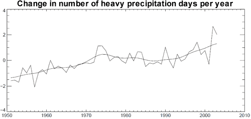
Figure 3: Global number of days per year when precipitation was greater than 10mm per day, expressed as an anomaly from the 1961 tp 1990 reference period (Alexander 2006).
Snowstorms can occur if temperatures are in the range of -10°C to 0°C. Global warming decreases the likeliness of snowstorm conditions in warmer, southern regions. However, in northern, colder regions, temperatures are often too cold for very heavy snow so warming can bring more favourable snowstorm conditions (Kunkel 2008). This is borne out in observations. Over the last century, there has been a downward trend in snowstorms across the lower Midwest, South and West Coast. Conversely, there's been an increase in snowstorms in the upper Midwest East, and Northeast with the overall national trend also upwards (Changnon 2006).
To claim that record snowfall is inconsistent with a warming world betrays a lack of understanding of the link between global warming and extreme precipitation. Global temperatures in the last few months of record snowfall are some of the hottest on record. Warming causes more moisture in the air which leads to more extreme precipitation events. This includes more heavy snowstorms in regions where snowfall conditions are favourable. Far from contradicting global warming, record snowfall is predicted by climate models and consistent with our expectation of more extreme precipitation events.
Intermediate rebuttal written by John Cook
Update July 2015:
Here is a related lecture-video from Denial101x - Making Sense of Climate Science Denial
Last updated on 26 October 2016 by pattimer. View Archives


Deniers I've argued with about this claim that this is a "post prediction" in that scientists were earlier saying we should expect warmer and drier witners. Can someone provide me articles dis-proving this claim?
dvaytw - in very general terms, the Clausius–Clapeyron relationship between temperature and water vapour is known from mid-19th C. Issues with precipitation were flagged in Ch 4 of WGII of the IPCC FAR 1990. Beyond the broad picture however, regional climate prediction was not possible then (and remains a considerable challenge now -see for instance here) and so perhaps you ask the source of the their claim for drier winters?
Molsen,
This copy of the graph Daniel Bailey posted on another thread yesterday shows that spring snow extent has decreased for decades. Your "dozen years" includes the lowest ever measured snow extent. It is clearly a blatant cherry pick starting after snow extent collapsed.
The Rutgers snow lab also has winter and fall graphs"
fall:
I see little winter change while fall is increasing. It appears that the additional atmospheric water is causing increasing snowfall when it is cold in spite of the fact that temperatures have increased.
According to this peer reviewed article (written by a Rutgers scientist):
"Annual snowfall is projected to decrease across much of the Northern Hemisphere during the twenty-first century, with increases projected at higher latitudes. On a seasonal basis, the transition zone between negative and positive snowfall trends corresponds approximately to the −10°C isotherm of the late twentieth-century mean surface air temperature, such that positive trends prevail in winter over large regions of Eurasia and North America. Redistributions of snowfall throughout the entire snow season are projected to occur—even in locations where there is little change in annual snowfall. Changes in the fraction of precipitation falling as snow contribute to decreases in snowfall across most Northern Hemisphere regions, while changes in total precipitation typically contribute to increases in snowfall."
It appears that the observed changes in snowfall are what scientists expected in advance.
I find it striking that two different new posters mention snow extent. Did WUWT have a snow article this week?
It is commonplace that when winter arrives and heavy snowfall occurs that someone, somewhere will trot out the alleged quote in 2000 from David Viner, formerly of the University of East Anglia that 'within a few years winter snowfall will become "a very rare and exciting event".' Supposedly he also said, 'Children just aren't going to know what snow is'.
I searched this site and was unable to verify whether the quote is accurate. Specifically, whether he actually said 'in a few years' back in 2000. I couldn't find anything from Viner himself as to whether he was quoted accurately. It's not that this quote has any relevance to climate science in general — we all make comments that we wish we hadn't made. But I did want to know whether the quote is accurate for that moment when someone will bring it up in the local press. Thanks in advance!
JoeT @8,
Most internet references to the Viner comment appear to cite an article in the Independent of 20/3/00 but the links to this article yield "page not found". But for the curious, a PDF of the article has been preserved by the denialists on the rogue planetoid Wattsupia. Note the later Viner quotes in the artiucle.
Joe T @8,
I share your interest and curiosity regarding those quotes by David Viner in 2000.
My admittedly amateur search on the Internet of Knowledge (and a massive amount of nonsense), found the earliest mentions to be in 2010 by climate denying people presenting their 'interpretations (potentially misunderstandings) of the quotes'.
It does not appear that any of them asked for clarification from the person they quote. That, along with the 10 year delay in making claims about the quotes, is a Red Flag to me. There appears to be no mention of David Viner's updated thoughts on the matter (I have read about the many incorrect statements made by Einstein that he later corrected).
The response by Tamino dated March 5, 2011 (here) appears to be a sensible evaluation of the merits of claiming that Viner's comments in 2000 are proof that climate scientists make incorrect statements. In this case the evidence appears to indicate that Viner was correct to say what he said in 2000. Mind you, if he had made an incorrect statement he later corrected it would also be incorrect to bring up the previous incorrect statement as evidence that 'in general' climate scientists 'are incorrect'.
On this David Viner quote from 2000 discussed @8,9&10, I think it's fair to say it applies to Southern England and is saying snow (perhaps lying snow rather tha snowfall) will be a lot rarer in coming years.
The Met Office does produce UK maps of both 'snow days' and 'snow lying days' for 30-year periods. These show decline in both with the more dramatic decline in 'snow days' although the most recent version of these maps (1991-2020) are yet to be published. (See maps in Fig 1 in this CEH 'Snow in Britain: the historical picture and future projections' document from 2016).
Of course, all these maps are saying is that the 1990s were less snowy than the 1960s and the 2000s less snowy than the 1970s.
There is a better reckoning showing to winter 2012/3 in this 2013 Reading Uni blog which shows graphs of the annual number of 'snow lying days' at Reading since 1948/9. This shows the decline in snowiness up 2008 was reversed in the following years.
Another less-exacting attempt to show the level of UK snow is graphed out by decade below, based on this record here. Taking the method up-to-date puts the latest ten-years (2011/12-to 2020/21) at 22, so the snowiness is again showing decline, although a couple of 'very snowy' years would soon boost that up again.