Climate Science Glossary

Term Lookup

Enter a term in the search box to find its definition.

Settings

Use the controls in the far right panel to increase or decrease the number of terms automatically displayed (or to completely turn that feature off).

Term Lookup

Settings


All IPCC definitions taken from Climate Change 2007: The Physical Science Basis. Working Group I Contribution to the Fourth Assessment Report of the Intergovernmental Panel on Climate Change, Annex I, Glossary, pp. 941-954. Cambridge University Press.

Home Arguments Software Resources Comments The Consensus Project Translations About Support

Twitter Facebook YouTube Mastodon MeWe

RSS Posts RSS Comments Email Subscribe


Climate's changed before
It's the sun
It's not bad
There is no consensus
It's cooling
Models are unreliable
Temp record is unreliable
Animals and plants can adapt
It hasn't warmed since 1998
Antarctica is gaining ice
View All Arguments...


Username
Password
New? Register here
Forgot your password?

Latest Posts

Archives

An overview of Greenland ice trends

Posted on 11 November 2009 by John Cook

In a recent post Accelerating ice loss from Antarctica and Greenland, we saw that ice loss from Greenland has been accelerating sharply over the last 9 years. One commenter suggested 9 years was too short a period. As I'm always harping on about the dangers of focusing on one narrow piece of the puzzle while neglecting the broader picture, perhaps I should practise what I preach. So I've revised the page on Greenland ice trends, adding the latest GRACE satellite measurements but also including long term trends going back to 1958.

Global warming affects Greenland in two ways. Warming temperatures cause the ice sheets to thin and lose ice mass around the edges. On the other hand, warmer temperatures also cause more snow to fall in Greenland's interior. Which has the greater effect? Is Greenland losing or gaining ice? 

Over the years, a variety of techniques have been employed to measure Greenland's mass balance. Snow pits are dug to measure snowfall. Stations are set up to measure incoming and reflected sunlight. Aircraft use laser altimetry to measure changes in surface elevation. Melt areas are determined by satellites reflecting microwaves off the surface. Satellite radar interferometry measure the horizontal movements of Greenland's glaciers. In 2003, NASA launched the Ice, Cloud, and Land Elevation Satellite (ICESat), using laser altimetry to more accurately measure changes in the Earth’s surface elevation.

All this data has been pieced together to form a continuous picture of Greenland's mass balance from 1958 to 2007 (Rignot 2008 - H/T to Chris for the heads up). There is robust agreement between the various independent measurements and a clear long term trend is apparent. In the 1960s, the ice sheet was losing 100 gigtonnes of ice per year. In the 1970s-1980s, the rate of ice loss slowed to near mass balance. In 1996, the rate of ice mass loss had increased to 97 gigatonnes per year. In 2007, the ice mass loss increased rapidly to 267 gigatonnes per year. To put this into perspective, a gigatonne is one billion metric tonnes, the mass of a cube of water that is 1 kilometre wide, tall, and deep.

So we see a long term trend of accelerating ice mass loss since the 1970s. This is confirmed by the Gravity Recovery and Climate Experiment (GRACE) satellite, measuring shifts in Earth’s gravity field. The GRACE data offers a complete picture of the entire ice sheet, allowing comparisons of mass changes in coastal regions (eg - elevations below 2000 metres) with the Greenland interior (above 2000 metres). Over the period 2003 to 2008, the coastal regions were observed to be losing ice mass while the interior was in approximate mass balance. The overall result is that the Greenland ice sheet is losing ice mass (Wouters 2008). 


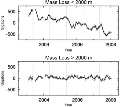
Figure 1. Mass loss from the Greenland ice sheet for coastal regions below 2000 metres (top) and interior regions above 2000 metres (bottom). (Wouters 2008)

The latest GRACE data reveals more about the long term trend. Figure 2 shows the ice mass changes in Greenland from April 2002 to February 2009 (Velicogna 2009). The blue line/crosses show monthly values of ice mass. The red crosses have seasonal variability removed. The green line is the best fitting quadratic trend. The best fitting trend finds that Greenland ice loss is accelerating at a rate of 30 Gigatonnes/yr2. Greenland's mass loss doubled over the 9 year period.


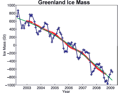
Figure 2: Time series of ice mass changes for the Greenland ice sheet estimated from GRACE monthly mass solutions for the period from April 2002 to February 2009. Unfiltered data are blue crosses. Data filtered for the seasonal dependence using a 13-month window are shown as red crosses. The best-fitting quadratic trend is shown (green line). (Velicogna 2009)

The long term trend since the 1970s is accelerating ice mass loss. This is confirmed by gravity satellite measurements over the past 9 years which find that the rate of ice mass loss has doubled over the last 9 years. Just as with Antarctica, Greenland's ice sheet contribution to rising sea levels is continuously and rapidly growing.

0 0

Printable Version  |  Link to this page

Comments

Comments 1 to 40:

  1. "It is important to note, however, that the ice sheets are also still likely to be responding to changes in forcing at the end of the last glacial around 12 ka BP. As a consequence, they will be out of equilibrium with respect to the modern-day climate, and their reaction to external forcing is an integrated response to changes over multiple millennia." http://www.pages.unibe.ch/products/newsletters/2009-2/Special%20section/science%20highlights/Bamber_2009-2(52-54).pdf A balanced 'quick' overview of both N & S ice sheets which is worth reading alongside "Why the Greenland & Antarctic ice sheets are not collapsing" http://icecap.us/images/uploads/OllierPaine-NoIceSheetCollapse-AIGNewsAug.2009.pdf
    0 0
  2. re #1; Yes Bamber’s paper is consistent with the general scientific observations that both Greenland and Antarctic mass balance loss is increasing:
    ”Thus, although there is a lack of consensus about the absolute value for the mass balance of the ice sheets, there is agreement that the trend has become increasingly negative for both Greenland and the WAIS.”
    There seems to be little doubt about that. You’ve selected a quote from Bamber’s article about the ice sheet responses. While it’s true that equilibrium responses are only realised on very long time scales (infinitely long in principle), analysis of sea levels in the late Holocene support the conclusion that ice sheet melt contributions to sea level rise had more or less come to equilibrium by around 3000 years ago (some evidence supports a lack of polar ice sheet contributions to sea level change by 6000 years ago). So although it’s not a straightforward analysis, the evidence indicates that sea levels have been pretty static at least for the 1000-2000 years before the mid-18th century, and the modern period of accelerating sea level rise encompasses only the last around 100-odd years [*]. Those observations are inconsistent with the notion that the polar ice sheets are out of equilibrium with the glacial-interglacial forcing of 12ky ago, to an extent that has real world significance, at last with respect to mass balance and sea level rise. [*] Pirazzoli PA (2005) A review of possible eustatic, isostatic and tectonic contributions in eight late-Holocene relative sea-level histories from the Mediterranean area Quart. Sci. Rev. 24, 1989-2001
    “Finally, several data from tectonic and non-tectonic areas are consistent with nearly stable global eustasy since 6000BP, thus challenging the assertion of significant additional melting of Antarctica after the complete melting of the former Northern Hemisphere ice caps “
    Lambeck K (2005) Sea level in Roman time in the Central Mediterranean and implications for recent change Earth Planet. Sci. Lett. 224, 563-575
    “Part of this change is the result of ongoing glacio-hydro isostatic adjustment of the crust subsequent to the last deglaciation. When corrected for this, using geologically constrained model predictions, the change in eustatic sea level since the Roman Period is -0.13 +/- 0.09 m. A comparison with tide-gauge records from nearby locations and with geologically constrained model predictions of the glacio-isostatic contributions establishes that the onset of modem sea-level rise occurred in recent time at similar to 100 +/- 53 years before present.”
    Church JA et al. (2008) Understanding global sea levels: past, present and future Sustainability Sci. 3, 9-22
    “While sea levels have varied by over 120 m during glacial/interglacial cycles, there has been little net rise over the past several millennia until the 19th century and early 20th century, when geological and tide-gauge data indicate an increase in the rate of sea-level rise.”
    Milne GA (2009) Identifying the causes of sea-level change Nature Geosci. 2, 471-478
    ”The observed fall in sea level following the end of major melting (~7,000 yr bp; Fig. 3b) is due to isostatic processes52. A growing number of high-resolution records (Fig. 3c) detect an acceleration in sea level around AD 1850–1900 (refs 43–45)”
    etc….
    0 0
  3. #2 "....analysis of sea levels in the late Holocene support the conclusion that ice sheet melt contributions to sea level rise had more or less come to equilibrium by around 3000 years ago (some evidence supports a lack of polar ice sheet contributions to sea level change by 6000 years ago). So although it’s not a straightforward analysis, the evidence indicates that sea levels have been pretty static at least for the 1000-2000 years before the mid-18th century, and the modern period of accelerating sea level rise encompasses only the last around 100-odd years" Have sea levels been unchanged for the past 1000-2000years? That is no change at all!! I realise this is from a skeptics website but the graph seems to tell a different story http://www.climateaudit.org/?p=61 . Can't confirm this Dutch finding but I'm prepared to believe in some variation in every natural process and not complete stasis until you hit the industrial age. Actually you would get what you describe if you put a trend line in that graph i.e. levelling out about 3000years ago but you would lose the detail that puts the recent sea level changes in perspective. In terms of the above article I still think you don't give full justice even to the data you present. In summary 1960s ~100 gigatonne loss 1970s-1980s no change 1990 rising to ~100 2007 347 gigatonne loss you suggest at the start of the article that data from 1958 will show accelerating ice loss. Half way thourgh you abandon the first section of the data to state "So we see a long term trend of accelerating ice mass loss since the 1970s". When in reality the data from 1958 to 1996 says steady or no loss. It still looks to me like you're relying on the last 6-7 years of GRACE data to cocclude accelerating ice loss.
    0 0
    Response: Note that the climateaudit post you link to is talking about sea levels at one particular location in the Netherlands. The post also notes that "the part of the Netherlands which is below sea-level is sinking as a result of post-glacial rebound" (although I would've thought post-glacial rebound causes the land to rise - perhaps a mistype).

    "you suggest at the start of the article that data from 1958 will show accelerating ice loss"

    To be precise, I said we'll look at "long term trends going back to 1958". And what we find is a "long term trend of accelerating ice mass loss since the 1970s". We've gone from approximate mass balance to gradually increasing ice loss. This is independent of GRACE data.
  4. John, the Netherland and Denmark are on the same tectonic plate as the Scandinavian peninsula. As a boat that rise on one side and sink on the other when put away some weight from just one side, the plate is rising on the scandinavian side and sinking on the other side because there was much more ice on the scadinavian side of the plate.
    0 0
  5. re #3 The point refers to the effects of polar and land ice melt on sea levels as a result of the Glacial to Holocene transition. The evidence indicates that the bulk of this was realised by around 6000 years ago, and that for the last 2000 years, the nett change in sea level before around the last 100ish years was negligible (they may have actually gone down a tad in the period from the Roman era to the mid 19th century); so at the very least, any residual post-glacial melt has been balanced by snow deposition. Sea levels likely went up and down a bit during that period, but the modern increase in sea levels as a result of ocean warming and mountain and polar ice retreat is resulting in a nett rise in sea level (that is expected to accelerate as temperatures continue to rise). As pointed out already, the metric of interest is the eustatic sea level rise, which is the mean sea level. Obviously the effects of post glacial rebound and depression and local tectonic effects means that extreme care must be taken to assess eustatic sea leels and their changes that are independent of land surface changes. So in general eustatic sea levels are determined in the mid-latitude (Carribean/Meditteranean) far from direct effects of post-glacial rebound. Care must still be taken to assess other tectonic effects (e.g. the Greek mainland is sinking towards the SW as a result of collapse around the edges of the Tibetan plateau which has been pushed up (against its will!) by the Indian sub-continent. So eustatic sea level change is not a straightforward measure...
    0 0
  6. Analysis of surface mass balance "Results from the high-resolution run with RACMO2.1/GRN are shown in Figure 1. It is found that total annual precipitation on the Greenland ice sheet for 1958-2007 is up to 24% and surface mass balance up to 63% higher than previously thought." and.. "RACMO2.1/GRN is able to simulate a realistic spatial and temporal SMB for the Greenland ice sheet for present-day climate conditions. Our findings show that considerably more mass accumulates on the GrIS than previously thought. The higher resolution, the used ice sheet mask and the redundant need for post-calibration could be a cause for disagreement between models." The combined graph of precip./melt/runoff/mass balance shows the beginning (maybe?) of a recovery from 2007.
    0 0
    Response: Thanks for the link, I've turned it into a hyperlink as the URL was quite long. That data is a little older than the GRACE data which shows that ice mass loss has continued past 2007 - see Figure 2 above.
  7. As the authors themselves say, it is "the classic pattern expected in a warming climate, with increased snowfall in the interior and enhanced runoff from the marginal ablation zone." Also noteworthy is that they date the onset of significant response of the ice sheet to 1990.
    0 0
  8. Response and #5 I take your points but teh climateaudit graph shows rises and falls over the last 2000years with no real nett change. I'm aware that misleading data supporting sea level rises has been used in the past. From memory, data from around Hong Kong and a Pacific Island (i think Tuvalu). So certainly making the correct measurements is important. No nett change can still mean ups and downs in the intervening time. And the recent up needs to be put into that context. I guess the point I'm making is that to argue absolutely no change over the last 2000years followed by sudden rise during the industrial age would be extremely damming. But putting the recent change into the context of a naturally dynamic system, which is undoubtedly the case, requires a little more sophisication. Would you put 100% of the sea level rise this century down to AGW? Sorry this has strayed off topic from Greenland
    0 0
  9. re #8 It's worth pursuing this point, since Greenland ice melt, past, present and future, is quite relevant for sea-level change past, present and future (so necessarily off-topic!). The Dutch data you linked to is difficult to assess since none of the links to the data on that web site are live. So we can’t tell what the Dutch data is, where it was taken, and whether it refers to local relative sea level (I suspect it does) or global eustatic sea level (very likely not). However we can look at data published in recent years that bear specifically on mid-late Holocene sea level variation in the coastal regions near and around Holland, and more generally at papers that assess late Holocene variation in global eustatic sea level, in other words the absolute change in sea level arising from warming/cooling and mass influx (ice sheet melting) and decrease (ice sheet expansion), that is independent of the local post-glacial isostatic effects, land subsidence, and so on, that can give rise to spurious interpretations. So on local (Dutch and environs) late Holocene sea levels, an analysis of sea levels from a region less than 100 miles to the NE of N Holland doesn’t show any up-down variation in regional sea level during the Holocene, although there has been a step-wise increase in relative sea level during the mid-late Holocene, largely due to post-glacial subsidence: Bungenstock F, Schafer A (2009) Holocene relative sea-level curve for the tidal basin of the barrier island Langeoog, German Bight, Southern North Sea, Global Planet. Change 66, 34-51 Likewise, a very comprehensive analysis of Holocene sea level data that covers a large chunk of the NW European coast (the coasts of Germany, Belgium, Holland) indicates very little upwards and downwards variation in sea level. There is a general rapid rise to around 6000 years ago with much slower subsequent sea level rise, and the data fit well to eustatic sea level analyses indicating rather little rise or fluctuations during the last 2000 years: Vink A et al (2007) Holocene relative sea-level change, isostatic subsidence and the radial viscosity structure of the mantle of northwest Europe (Belgium, the Netherlands, Germany, southern North Sea) Quatern. Sci. Rev. 26, 25-28 More generally a recent review of sea level change indicates that sea level variations have been of low amplitude throughout the couple of millennia before the industrial age: G.A. Milne et al (2009) Identifying the causes of sea-level change Nature Geosci. 2, 471-478
    Sea-level observations for the mid- to late Holocene provide constraints on the natural variability of sea-level change immediately preceding the industrial revolution. These data indicate that local rates were generally at the 1–10 cm per century level (see Table 1).
    So considering the relevant global parameter of eustatic sea level variation resulting from ice sheet/glacier mass balance and ocean temperature variations, there doesn’t seem to be much evidence for very significant fluctuations in global sea level, at least in the couple of millenia before the industrial age. Even if we consider local relative sea level where postglacial isostatic effects, land subsidence, tidal range variations and so on influence the local sea level, I can't find anything that shows the variability in the unattributed data set you linked to, and that includes data in papers that cover the equivalent coastal region (see papers cited above). If you could find the source of the data you linked to I'm mildly curious to see what it actually is... I don't think this is at all straightforward, and there is still uncertainty in mid-late Holocene sea level variation. However there just doesn't seem to be any evidence for the large scale fluctuations that your link might imply, and the recent papers/reviews on this support the opposite interpretation. I'm afraid I haven't found downloadable versions of the papers cited...
    0 0
  10. I've only had time to read the Milne paper. Here's the PDF for those interested. 'These data indicate that local rates were generally at the 1–10 cm per century level" As you know this data is from one type of measure, salt-marsh stratigraphy, that work was done in one local (East Maine) so as you pointed out to me one localality shouldn't be used to represent global averages. The papers presentation of a much wider selection of data is informative That paper is eye openning in its honesty about the number of variables and inherent difficulties associated with these sort of measurements. I read Milne and took from that not that we could give definitive numbers to the last 2000years of sea level and beyond but that the science still has a long way to go. I still don't think anything presented in that paper says stasis for 2000years followed by rises in the industrial age. From what I read the rise in the 20th century was between 10-30cm depending on which data set you use. In table one Milne says the salt marsh data covers the last 500years and the maximum sea level change within that period is 20cm/century Also this graph is useful, try to ignore the pending apocalypse portrayed for the future and focus on the little hill around 1200AD (the Medieval Warm Period???) when sea levels were higher than today. Back to Greenland by way of North America There is something that caught my attention a while back and which was briefly mentioned in the Milne paper, the Laurentide ice sheet. This was a huge ice sheet that cover North america down to New York and slow melted over the past 20000 years. You could see the Greenland ice sheet as the remmnents of it. There is a cartoon of it's historical retreat here. I was wondering how that fits in with long term story of the Greenland ice sheet? It should be noted that the retreat hasn't been an even process and at times it's even grown. I wonder whether we should expect anything other than a retreating Greenland ice sheet?
    0 0
  11. I was going to ask what the total amount of ice there was in Greenland, but then realized this was a dumb question when I could just look it up. So I did. http://en.wikipedia.org/wiki/Greenland_ice_sheet says it is 2.85 x 10e6 km3, or 2.85 x 10e9 m3 . Sounds like a lot of ice. Then taking your acceleration of 30 x 10e9 tons/yr2, (if we ignore the initial condition) this equates to solving this as a falling body at rest d=(1/2)gt2. Solving for t, leads to years = sqr(2 x 2.85 x 10e9/30) = 13,784 years. Sounds like a lot of ice up there.
    0 0
  12. Sorry. Looking at the units, I see I forgot to add another assumption. That 1 m3 of ice weighs one ton, which it does not. At any rate, it is probably close enough to give an idea of the general order of magnitude in years. Should anyone really be concerned even if it were 10,000 or 5,000 years?
    0 0
  13. RSVP: your sums are a bit out I think.... A km3 of ice is 10E9 tonnes ( roughly),so 2.85 x 10E6km3 is 2.85 x 10E15 tonnes. Since 2002 the loss is 1100 x 10E9 tonnes, or 157 x 10E9 T/yr as an average - so if the rate continues in a linear fashion it would take around 10,000 years to melt all the ice ( which cannot happen). But the rate is accelerating at around 30Gt/yr so in 5 yrs the loss will be around 300Gt/yr.
    0 0
  14. re #10 (i) Your first point is incorrect HumanityRules on two levels (I think you've misread Milne et al.) Firstly the data isn't from one type of measure, from one locality. Milne is using the Maine salt marsh data as a detailed illustration of local relative sea level variability. However their paper is a review, and their conclusions come also from other papers cited(specifically, as they indicate, from coral microattols from the Cook Islands; foraminifera from peat deposits on the Connecticut coast; salt marshes on the coast of Denmark). And there are many other examples including the papers I cited on relative sea level variation in NW Europe in post #9. The bigger error, is to mistake local relative sea level for global eustatic sea level. Milne et al present the evidence that even considering local variation in sea level (that may have post glacal isostatic and land subsidence contributions etc.), this is smallish (generally 1-10 cm per century). (ii) Let's look at global eustatic sea level. You've linked to another unattributed picture in your post. This turns out to be a model of past and projected sea level rise from this paper [*]. Presumably you want us to take it at face value, so let's do so: (a) Grinsted et al use historical temperature data to estimate possible sea level variation during the last 2000 years. For example, they suggest that during the period from around 600 AD to 1150 AD in the Medieval Warm period), sea levels might have risen by around 25 cm. This is about 15% of the sea level rise during the same period in the earlier picture you linked to in your post #3 (which presumably you now reject; they can’t both be correct). It corresponds to a bit over 2 cm per century. If one takes the Grinsted analysis at face value we may well expect around 1 metre of sea level rise during the 21st century. (b) So the data you’ve presented to us indicates the sea level rise of the 21st century may occur at close to 50 times the rate of sea level rise associated with what is considered to be the transition to the warmest period in the previous 2000 years before the middle of the 20th century (sea levels are already rising around 15 times more quickly than during the period pictured in the graph you linked to). If you were to put the projected 21st century rise on the same horizontal time scale as the previous 2000 years in your picture, it would be near vertical. Isn't this all pretty consistent with Milne et al.? They review data that shows rather little preindustrial variation in eustatic sea level; that current measurements show sea levels are already rising much faster (by more than 10-fold) that even during the rise to the MWP; and that we are pretty certain to get significantly increased rates during the current century. It's certainly inconsistent with the old graph you linked to from that dodgy web site (your post #3). (iii) In a previous post (#8) you asked the question "Would you put 100% of the sea level rise this century down to AGW?". If you look more widely at the NERC Planet Earth site from which you cut and pasted that lonely figure from Grinsted et al (2009) you would have found an analysis that addresses your question: http://planetearth.nerc.ac.uk/news/story.aspx?id=551 Jevrejeva et al determine that almost 80% of sea level rise during the 20th century is as a result of anthropogenic greenhouse forcing. In fact they point out that the anthropogenic contribution to sea level rise was likely suppressed somewhat by volcanic eruptions: "If no volcanic eruptions had happened since 1880, then sea-level rise over the last century would've been seven centimetres higher than it was," explains Jevrejeva. [*]A. Grinsted et al. (2009) Reconstructing sea level from paleo and projected temperatures 200 to 2100 AD Climate Dynamics; in press. [**] Jevrejeva, S et al (2009) Anthropogenic forcing dominates sea level rise since 1850 Geophys. Res. Lett., doi:10.1029/2009GL040216, in press.
    0 0
  15. today's Science has a relevant paper: M. van den Broeke et al. (2009) Partitioning Recent Greenland Mass Loss Science 326, 984-986 (November 13, 2009) http://www.sciencemag.org/cgi/content/abstract/326/5955/984 abstract: Mass budget calculations, validated with satellite gravity observations [from the Gravity Recovery and Climate Experiment (GRACE) satellites], enable us to quantify the individual components of recent Greenland mass loss. The total 2000–2008 mass loss of ~1500 gigatons, equivalent to 0.46 millimeters per year of global sea level rise, is equally split between surface processes (runoff and precipitation) and ice dynamics. Without the moderating effects of increased snowfall and refreezing, post-1996 Greenland ice sheet mass losses would have been 100% higher. Since 2006, high summer melt rates have increased Greenland ice sheet mass loss to 273 gigatons per year (0.75 millimeters per year of equivalent sea level rise). The seasonal cycle in surface mass balance fully accounts for detrended GRACE mass variations, confirming insignificant subannual variation in ice sheet discharge.
    0 0
  16. To Mizimi Thank you for pointing out my error. You are right about the exponent, which was also missing in the denominator. Plugging new values in gives us... years = sqr(2 x 2.85 x 10e15/30 x 10e9) = 436 years hmmmm... how long do you have to boil a hat to optimize digestion?
    0 0
    Response: You're remarkably blase about the potential 7 metres sea level rise from the collapse of the Greenland ice sheet not to mention a similar contribution from the Antarctic ice sheet. Surely you realise the impact of such a sea level rise on humanity.
  17. RSVP, i've never thought of doing this rough calculations. This means that assuming not even partial rapid collapse of the ice sheet we'd get 16 mm/yr, 1.6 m in a century, from Greenland alone. Pretty scaring, indeed; let's hope it will slow down. Take it easy Greenland!! :)
    0 0
  18. The Greenland ice sheet cannot 'collapse'. The ice sheet sits in a basin around 300m below sea level surrounded by mountains...whether the basin is due to the weight of the ice or was there originally is not clear. What is clear from core samples is that the central and most massive portion of the ice sheet has not changed for over 100,000 years. What we are seeing now is increased melt and ablation at the edges of the ice sheet which ,if it continues, will diminish as the central sheet becomes unable to sustain the flow outwards. So there cannot be a collapse and no 7m rise in sea level.
    0 0
  19. RSVP, i didn't want to say that the GIS might collapse altogether. There might be partial collapse along the slopes at the edges. How comes that GIS cannot release all of it's ice? Given that we are heading toward temperatures never seen in the last several hundreds thousands years (not just 100,000), the GIS is definitely capable of releasing all of its ice and allow a 7 m sea level rise. It's just a matter of how much warming and how much time it takes.
    0 0
  20. Mizimi, as ice is shed, isostatic rebound could bring the underlying land quite a bit higher, so all that ice might not be as safely land locked as you say.
    0 0
  21. John, Sorry if I came across that way. My comment was only in reference to the math error, and I appreciated Mizimi's pointing it out. By the way, he also says something later that seems reasonable, implying that the ice mass acceleration is not necessarily a constant, and would tend to diminish as soon as the bulk of the peripheral ice fields disappear. I am sure the problem is much more complex, and even the simplest models would depend on a series of functions that reflect the dynamics of various stages. Personally, I dont think it is at all realistic to extrapolate to 436 based on a second derivative extracted from the fuzz of nine samples. It is however useful to give some feel of a worst case scenario and perhaps what is possible. However, another very simple calculation with the same data leads to very different conclusion. That is to assume acceleration is zero or neutral, but that the ice loss rate (slope) is constant at the current rate. From the curve, we see about 1500 x 10e9 T/year over a 6 year period, which equals 250x10e9 T/year. Using the same value for total ice... 2.85 x 10e15 T / 250 x 10e9 T/y = 11,400 years.
    0 0
  22. The notion that future melt can be assessed/dismissed by back of the envelope numerology and false arguments, isn’t very helpful. There has actually been substantial recent investigation of this problem: (i) Recent analysis indicates that 21st century sea level rise is likely to be well in advance of the IPCC estimate. Projected 21st sea level seems to be closer towards the 1 metre level and this requires “non-linear” effects on ice sheet dynamics that are consistent with elements of “collapse”. HumanityRules brought a recent paper on sea levels to our attention. This projects a 1 metre 21st century rise based on an analysis of temperature-dependence of past sea level rise [1]. A recent analysis of the contributions of ice sheet dynamics to sea level rise supports a projection of 0.8-2.0 metres of 21st century sea level increase [2], although rises towards the lower end of the range are considered more likely. These all support very substantial attenuation of the Greenland ice sheet in the 100’s of years timescale. [1] A. Grinsted et al. (2009) Reconstructing sea level from paleo and projected temperatures 200 to 2100 AD Climate Dynamics; in press [2] W. T. Pfeffer et al. (2008) Kinematic Constraints on Glacier Contributions to 21st-Century Sea-Level Rise. Science 321, 1340-1343 (ii) Mizimi suggests that the 300 metre depression of the central Greenland ice sheet resulting from isostatic depression precludes ice sheet collapse. However the average height of the Greenland ice sheet is over 2100 metres, and there is obviously plenty of scope for major Greenland collapse yielding substantial (several metres) contributions to sea level rise. Analysis of the Greenland bedrock topography identifies multiple outlet channels (460 of these), of which only around 36% have been activated up to the year 2000 [3]. These potentially allow increasingly rapid rate of outlet flow from the ice sheet. Likewise an analysis of rapid retreat of the Sam Ford Fjord glacier during the last glacial to Holocene transition 9500 years ago suggest that glaciers with very similar topologies in Greenland and West Antarctica can undergo rapid retreat (10’s to 100’s of kilometers in the coming centuries) [4]. [3] Lewis S. M. et al. (2009) Hydrologic drainage of the Greenland Ice Sheet Hydrol. Process. 23, 2004-2011 [4] Briner J. P. et al. (2009) Rapid early Holocene retreat of a Laurentide outlet glacier through an Arctic fjord Nature Geosci. 2, 496-499 (iii) While Mizimi suggests that the central regions of the ice sheet “has not changed for over 100,000 years” we know that isn’t true since the deepest (3000 metres) central Greenland cores reach bedrock at a bit over 100,000 years ago. So a large proportion of the central parts of the Greenland ice sheet have only been deposited during the last 100,000 years. As we know, during the last interglacial 125,000 years ago when Arctic temperatures were ~2 oC warmer than now, sea levels were 4-6 metres higher [5]. Much of this was from massive Greenland melt. [5] Allison I. et al. (2009) Ice sheet mass balance and sea level Antarctic Sci. 21, 413-426 (iv) Analysis of rates of sea level rise in the past are instructive about how ice sheets might respond to forcing from very fast temperature rise. During the transition to the present interglacial there was a period of very rapid sea level rise (meltwater pulse 1A, 14,600 years ago) when sea levels rose 20 metres in 500 years [6]. During the last interglacial 125,000 years ago when the situation was more comparable to the present, the transition to sea level highstands that were 4-6 metres above current sea level, occurred at rates of 1.6 metres per century [7]. These rapid large melts occurred during climate transitions with overall warming that was slower than current warming. [6] A. J. Weaver (2003) Meltwater Pulse 1A from Antarctica as a Trigger of the Bølling-Allerød Warm Interval Science 299, 1709-1713 [7] Rohling, E. J. et al. (2008) High rates of sea level rise during the last interglacial period. Nature Geoscience, 1, 38–42 (v) The Greenland ice sheet is pretty much committed to major melt already at current greenhouse gas levels. We know that ice sheet disintegration/melt in a warming world generally occurs much faster than ice sheet growth in a cooling world, since disintegration/melt can occur through dynamic processes, whereas growth is limited by the rate of precipitation. The evidence suggests that dynamic processes (flow transition from ice sheet to floating ice shelf; the dynamics of rapidly flowing ice streams and outlet glaciers; the effect of basal melt water on ice dynamic processes [5]), are likely to cause Greenland (and the West Antarctic ice sheet) to melt much more quickly than “back of the envelope” guesswork might imply…
    0 0
  23. #14 i)I think that was my point that the review looked at multiple points not just the salt marsh data which you originally quoted. I don't know where you get smallish (generally 1-10 cm per century) rates for natural sea level change from. Table two shows max rates for some of the more recent measurements (last 10,000years) at 0.1-0.2metres/century. Am I mis=understanding that table? The historical data is by it's nature local and for that matter sporadic. But it remains the best data we have i)If you take the 3 more accurate measurements for the past decade the review suggests between 1-3mm/year (thats 10-30cm/century if you extrapolate) see this long quote from Milne. Yhat is what I understand from this long quote from Milne "After applying corrections for these biases, several studies14-16 have shown greatly improved consistency, in one case14 finding a tightly-closed sea-level budget for interannual and seasonal cycles, but a significant imbalance of over 3 mm/yr in the trend. In the second case15, a smaller net imbalance of about 1 mm/yr was found (this is within the estimated error bars). In the third study16 GRACE data were used in two different ways, in one case using a larger geodetic correction over the oceans than in other studies, and in the other using it only to estimate Antarctic and Greenland mass loss, and combining with other datasets to estimate the total mass entering the ocean. These two methods both result in a balance to within a small fraction of one mm/yr." ii) a) I'm not sure which is correct. The Netherlands data could be correct for the local changes while the Grinsted paper could be accurate on a wider level so both figures could be right. Without accepting Grinsted's figure there does seem to be an error in your interrution of it. Grinsted is a simplified model which identifies a trend based on a relationship between temperature, ice melt and sea levels. There are other processes which cause short term speeding up and slowing down of the ice melt. I'd suggest you're wrong to try to give an averaged rate for the MWP. Similarly it would be wrong to give an average rate between two widely spaced data points as you have no way of knowing if the rate of sea level change remained constant over that time period. Especially when you are comparing it to a decade of detailed global data which by it's nature contains all that detail. I'm starting to think the whole process is invalid. b)Back to the Milne paper. If you take my answer to i) that puts the most recent decades increase well within historical changes or at worst twice historical rates, I don't see where you get the 50x value. iii) I'm pleased to here that graph wasn't lonely but I did find that article lacked logic.
    0 0
  24. "A recent study by Peter Chylek et al. (2006) put all of these Greenland temperature records together in one place (Figure 8 ), and commented: Although there has been a considerable temperature increase during the last decade (1995 to 2005) a similar increase and at a faster rate occurred during the early part of the 20th century (1920 to 1930) when carbon dioxide or other greenhouse gases could not be a cause. The Greenland warming of 1920 to 1930 demonstrates that a high concentration of carbon dioxide and other greenhouse gases is not a necessary condition for period of warming to arise. The observed 1995–2005 temperature increase seems to be within a natural variability of Greenland climate" http://www.worldclimatereport.com/index.php/2007/10/16/greenland-climate-now-vs-then-part-i-temperatures/ The GISS temperature graphs on this site ( covering coastal stations..the warmest bits) show annual means which rarely go above 0C. Given that the average height of the ice sheet is, as Chris points out, over 2000m, and add a lapse rate of 6C/km the annual avergae temp inland is not going to be far off -10 to -12C. Not much melt there I think. Also we do not know how much of that 300m depression was there before the ice (if any) so it is not possible to attribute all of it to the weight of the ice.
    0 0
  25. chris, I take it you didnt like the fact that the exact same data leads to two completely different predictions, (i.e., 436 years and 11,400 years). All I did in the first case was to use the acceleration derived from the data, and in the second case ignored the acceleration completely, but used the overall slope. In this sense, whatever information my calculations could possibly convey are equivalent to the graph,.. except that I was also considering the overall mass, which I assume is significant. So you may not find any of this helpful, but there is a certain usefulness in knowing what you cant know.
    0 0
  26. Mizimi, "a high concentration of carbon dioxide and other greenhouse gases is not a necessary condition for period of warming to arise". I know, this kind of trivial findings sometimes pass peer review. It pairs the logically false claim that becuase climate has changed in the past it cannot be the human influence this time. As for the graphs you quote, you should look at seasonal temperatures; you don't need yearly averages above 0 °C to melt ice during summer and for sure no one has ever claimed that there's melting in Greenland in winter ...
    0 0
  27. Riccardo: I think Chylek was referring to the warming of Greenland rather than warming in a global sense, although this is not specifically stated, I infer it from the fact that it is all one sentence. Also ( as John keeps telling us) climate is not about seasonal variations but long term trends, so those graphs are relevent. Only 2 out of the 6 graphs show coastal temps ever rising above 0C (for the periods covered). There is a distinct T rise 1920 -1940 followed by a cooling period and then another warming from 1990 on. But the average T is still below 0C. Box (SURVEY OF GREENLAND INSTRUMENTAL TEMPERATURE RECORDS:1873–2001)does a more detailed survey and notes the large effect of NAO, vulcanic activity and sea ice extent "Temporal and spatial variability are analysed in Greenland instrumental temperature records from 24 coastal and three ice sheet locations. Trends over the longest period available, 1873–2001, at Ilulissat/ Jakobshavn indicate statistically significant warming in all seasons: 5 °C in winter. Trends over the 1901–2000 century in southern Greenland indicate statistically significant spring and summer cooling. General periods of warming occurred from 1885 to 1947 and 1984 to 2001, and cooling occurred from 1955 to 1984. The standard period 1961–90 was marked by 1–2 °C statistically significant cooling. In contrast to Northern Hemisphere mean temperatures, the 1990s do not contain the warmest years on record in Greenland. The warmest years in Greenland were 1932, 1947, 1960, and 1941. The coldest years were 1918, 1984, 1993, and 1972, several of which coincide with major volcanic eruptions. Over 1991–2000, statistically significant 2–4 °C warming was observed in western Greenland, 1.1 °C warming at the ice sheet summit (3200 m), although this is statistically insignificant. Annual temperature trends are dominated by winter variability. Much of the observed variability is shown to be linked with the North Atlantic oscillation (NAO), sea ice extent, and volcanism. The correlation of coastal temperature anomalies with the NAO is statistically significant, in autumn and winter at western and southern sites. Warming from 1873 to 1930 and subsequent cooling persists after the removal of the NAO signal. Temperature trends are often opposite between west and east Greenland. This apparent teleconnection is spurious, however, given insignificant east–west correlation values. Frequency peaks correspond with periods of 3.7, 14.3, 9.1, 5.5–6.0, 11.1, and 7.1 years in both temperature and NAO"
    0 0
  28. re #23 You’re misunderstanding Milne et al again HumanityRules: (i)(a): The data you’re discussing from Milne et al is local, relative sea level change. Milne et al indicate that even taking into account the changes from postglacial isostsatic effects and land subsidence/uplift etc, that local relative sea level changes have been small during the few millennia before the industrial period, generally between 1-10 cm per century. The maximum local, relative sea level rates might be 20 cm per century, and perhaps larger as a consequence of major land slip or rise e.g. following large tectonic events like the one that resulted in the tsunami of a few yeas ago. But these are local, relative sea level changes that incorporate isostatic and vertical land motion effects as well as any eustatic absolute global sea level changes. It could hardly be clearer, since Milne et al say as much! Obviously if we’re interested in comparing anthropogenic warming induced contributions to sea level rise to that in the past we should consider the absolute global sea level change. We can look at that in point (ii) below. (i)(b) You’ve also misunderstood the long quote that you cut and pasted from Milne et al. This refers to an attempt during the past few years (when GRACE satellite measures have been available to estimate ice sheet mass loss), to partition the ~3.2 mm/yr sea level rise to its mass (land ice melt) and steric (warmth) components. There isn’t much uncertainty about the overall trend in sea level rise (~3.2 mm/yr) over the last decade or two (see: http://www.skepticalscience.com/Are-sea-levels-rising.html); a different uncertainty is being discussed in the bit of Milne et al. you cut and pasted. This results from uncertainties in “closing the budget”, whereby the GRACE altimetry-determined mass contributions and enhanced ocean heat steric contribution should sum to the observed sea level rise. This has been subject to confusion resulting especially from errors in ocean heat measures, but these seem to have been largely resolved very recently. So the evidence is quite strong that current absolute global eustatic sea levels are increasing around 3.2 mm/yr now. The paper on the site you liked to earlier indicates that the absolute global eustatic 20th century sea level rise was around 1.8 mm/yr overall (almost 80% of which was anthropogenic) [*]. So the rate of sea level rise is increasing and will continue to do so as temperatures continue to increase. That seems very straightforward. (ii) The evidence simply doesn't support large variation in rates of global absolute eustatic sea level during the last 2000 years (see papers/reviews cited in my post #2). You've shown us an analysis of sea level variation during the last 2000 years [**] that is quite consistent with the observations from paleoanalysis of eustatic sea levels. This paper indicates that the rate of sea level rise in the 21st century may well be around 1 metre/century, a rate that is broadly consistent with independent analysis (see Pfeffer et al (2008), cited in my post #22). The graph you showed us indicates that the warming during the very slow temperature rise into the MWP was around 2 cm/century. In otherwards, the graph that you brought to our attention indicates that the 21st century sea level rise might be around 50-times faster than the rate of warming to the MWP, the warmest period of the last 2000 years before the mid-20th century. You suggest now that you don’t like the paper. Specifically you suggest with respect to temperature-induced ice melt and sea level rise that “there are other processes which cause short term speeding up and slowing down of the ice melt”. But what might these be? Long lived temperature change is by far the dominant contribution to changes in sea level. It’s valid to consider this in relation to independent evidence for long term changes in temperature. In fact Grinsted et al use the rather extreme paloetemperature profile of Moberg et al [***] to determine their sea level changes. The temperature change to the MWP was very slow and long term, and the sea level rise was not-surprisingly likely similarly slow and long term. Now we're having a very rapid rise in temperature, that is taking global temperatures to levels already well above those of the MWP. So land ice is melting more quickly, the oceans a re warming more quickly, and sea levels are rising more quickly. [*] Jevrejeva, S et al (2009) Anthropogenic forcing dominates sea level rise since 1850. Geophys. Res. Lett., doi:10.1029/2009GL040216, in press. [**] A. Grinsted et al. (2009) Reconstructing sea level from paleo and projected temperatures 200 to 2100 AD Climate Dynamics; in press. [***] Moberg A et al.(2005) Highly variable northern hemisphere temperatures reconstructed from low-and high-resolution proxy data. Nature 433, 613–617
    0 0
  29. re #24,27 It's worth looking at Box et al (2009) [*] since these authors make a more detailed analysis of Greenland temperatures during the 20th century. Greenland warmed very significantly between 1919 and 1930 to an extent that has been larger than the 1990-present warming. The dominant influence (according to Box et al) is the effect of cooling sulphate aerosols from volcanic activity, to which Greenland is very sensitive. So the high degree of volcanic activity especially from the mid-late 19th century into the early 20th century suppressed Greenland temperature more that the global response. When this volcanic activity ceased, Greenland temperatures recovered rapidly and the suppresed anthropogenic and solar forcing was unleashed very quickly in the 1920's. A similar degree of suppression of Greenland warming occured due to the relatively high volcanic activity in the 1960's through 1980's. When this calmed down, Greenland warmed up to recover the warming represented in the rest of the world. In fact Box et al consider that Greenland warming has quite a bit to go (1 - 1.6 oC) to "catch up" with globaal scale warming.
    Over the 1840–2007 time span, two multidecadal low temperature periods (1861–1919 and 1963–84) in Greenland coincide with periods of multiple major volcanic eruptions. Greenland is most sensitive to volcanic (sulfate) cooling during the dynamically active winter season and along the western ice sheet margin, that is, when the equator-to-pole temperature differential is strongest and owing to the ice sheet topographic and baroclinic effect of planetary wave anchoring, respectively. Considering also that Northern Hemispheric cooling in 1940–70 is attributable to the ‘‘global dimming’’ effect of increasing sulfate aerosols, the sulfate cooling effect is, again, felt more strongly in Greenland, and indirectly via altered atmospheric dynamics not via local radiation budget modification.
    and
    In the early twentieth-century warming, Greenland anomalies surpassed the Northern Hemisphere anomalies in 1923, with close phase agreement between the two time series. In contrast, recent (1994–2007) regional warming around Greenland has not surpassed the hemispheric anomaly. Using the empirical relationships between Greenland and the Northern Hemisphere surface air temperature data, we calculate that if Greenland was to become in phase with the hemispheric pattern, as it did after 1923, an additional 1.08–1.68C warming would occur. In light of this prediction and global climate model forecasts for continued high-latitude warming, the ice sheet mass budget deficit is likely to continue to grow in the coming decades.
    [*] J. E. Box et al (2009) Greenland Ice Sheet Surface Air Temperature Variability: 1840–2007 J. Climate 22, 4029-4049
    0 0
  30. #28 Your right there was a lot of misunderstanding on my part. So from what you tell me the sparse historical data can tell us very little because it is only local relative sea level change. The potential for land movement means we can not rely on those measurements to tell us anything about absolute global sea level change. Then why continue to repeat the 1-10cm figure when it tells us nothing? Why not say we have no reliable measurable data before the 20th century. I now understand where you got the 50x figure from. I had misread the 21st for 20th. You didn't do what I asked and ignore the apocylyptic future. The point I was making with regard to the Grinsted graph was to do with the period upto the 20th century not into the future. This suggests that global sea levels were higher in the MWP than presently. Looking at the graph from Grinsted again there are areas of the graph at the run into the MWP were the slope (i.e. the rates of change of global sea level) looks very similar to the slope in the recent period. This rate slows up to the point that sea levels reach a peak. So there maybe periods in the MWP where rates of sea level change approached the rates of the last two decades. You suggest that sea level changes have been around 3.2mm/year for the past two decades with an average of 1.8mm/year for this century. Unless I misunderstand this, then that would mean a total of 18cm sea level rise for the 20th century? Back to Grinsted's graph. He shows about 30cm rise from 600AD to 1200AD. >40cm drop from 1200AD to 1700AD and then maybe >25cm rise from 1700AD to present. I'm unsure how you can square that with "The evidence simply doesn't support large variation in rates of global absolute eustatic sea level during the last 2000 years" when we are comparing that with the 18cm rise in the 20th century. (There is a little confusion for me in your quote above. Do you mean absolute changes or rate of changes?)
    0 0
  31. (i) Not really HR. I was addressing your specific points re local, relative sea level. The data obtained fron the central latitudes re global eustatic sea level changes (see reviews/papers cited in my post #2) indicate that eustatic sea level variation has been small in the latter parts of the Holocene, once polar ice sheet decay reached near equilibrium with Holocene temperatures. (ii) You can't accept Grinsted's pre-industrial sea level variation without accepting their 21st century projection. They are intimately linked within the same model. (iii) Sea levels may well have been higher during the MWP compared to now. The temperature rise to the high point of the MWP was very slow and prolonged, and land ice melt was able to come close to equilibrium with the forcing (higher temperature). We're well above the MWP temperature now, but contemporary temperature rise has been so rapid that we've only surpassed MWP temperatures since the 1970's. It takes an awful long time for (especially) polar and glacier land ice melt to re-equilibrate with a change in forcing, and so the rise in sea level well above the MWP level will take some time. It's rather tedious that you don't read the papers you refer to but this is very obvious from Grinsted et al (2009): they state:
    The 12–21 cm higher sea level stand during the MWP is likely the highest sea level since the previous interglacial period 110,000 years ago, and was produced by an extended period of warming, allowing time for glaciers and thermal expansion to reach a climatic balance. Hence, the cooler than present temperatures in the MWP is consistent with higher than present sea level. Table 2 (T 0) shows that the sea level at 2090–2099 will be higher than MWP even with no rise in temperatures above the present.
    That's obvious isn't it HR? We've been discussing glacier response times on the other thread. These are generally of the order of 10-100 years (largely depending on glacier geometry). The sea level response time is larger than that since it's dominated by the slow component of polar ice sheet melt (there may be faster dynamic response components). e.g. going back to Grinsted et al:
    The inclusion of paleo-temperature reconstructions allows us to determine that present-day sea level rise is dominated by a fast 200–300 year response time to temperature
    (iii) Yes 18 cm sea level rise for the 20th century [14 cm, or nearly 80% of which was anthropogenic according to Jevrejeva et al (cited in post #28)]. Sea levels are currently rising at ~3.2 mm per year. So sea levels rose more slowly during the earlier periods of the 20th century than now. As temperatures rise the rate of sea level rise increases. That's obvious isn't it? As temperatures continue to rise, ice sheet responses will be driven towards ever increasing new equilibrium (denuded) positions, and the rate of sea level rise will continue to increase.
    0 0
  32. Hi Chris, I think you've been quite clear that response time is about re-establishing equilibrium (ie the full response). I don't know how well HR distinguishes this from lag times, which I think for him are periods of nothing happening (no detectable beginning of a response). But I can't be sure, because I don't find HR's writing to be very clear. One thing I thought I should ask about your point (iii) above, surely as the amount of available ice left to melt decreases, the rate of sea level rise will decrease. We may be far from running out of ice, but it seems to me that ice retreating up mountains is harder to melt, and even a linear response in sea level could be expected from that. Or perhaps this is where the geography comes in, as land gets steeper as you go up? Maybe I should have limited my comment to: Can we say at what point in a steadily warming world sea level rise stops accelerating?
    0 0
  33. Chris i) I see you're reviews in post #2. I don't have time to read everything but essential these papers are using the same sort of data (archaeological, salt marshes etc etc) which Grinsted uses when looking beyond the sea gauge data. These have all the same problem that you have pointed out previously- local, sporadic etc etc. ii) Accepted. It works both ways. Grinsted graph shows higher peak temp in the MWP than in the year 2000. It there on the graph. iii) I'm not sure that the temp rise was very slow and prelonged. Sure the rise started in 600Ad and end around 1200AD but according to the Grinsted graph most of the rise occured over a much shorter time period. I have a real problem with the attempt to compared the rate say over the past 20years with an average rate over a period of 600years, it seems inherently flawed to me. Better would be to compare similar time periods. Obviously the scale on the Grinsted graph makes the following a little dodgy but still i think it gives good ball park figures. We agree sea levels have risen 18cmm in the 20th century. Lets pick a 100 year period around the MWP. let go for 1000-1100AD as this is the time of steepest rise on Grinsteds graph. Print the graph to fit A4 paper and you can probably measure about 10cm of sea level rise for that century. That puts the rate about half the average rate in the 20th century if you accept the 18cm figure. Are you now suggesting a 200-300year lag in sea level rise? So we are seeing sea level rise due to climate conditions from 1710-1810? Does that mean the 14cm rise in 20th century sea level rise which is anthroporgenic is due to mans activity in the 17th century? There seems a logic in consistency in this process #Steve It's an interesting point you make about Chris point iii). Another thing that had occured to me is that if the 1960-1970 represented and static and in some cases reversal of glacier melt than that offers the possibility that come the resumption of retreat post 1970s there is the possibility of an exaggerated bounce ice is cleared fro I aplologise for the poor posts they are usually rushed in the time between experiments and tend to try to cover too many point (like this one). But part of the problem is that I think this science is far from complete, often publications contain contradictory statements, expressing that uncertainty is a problem for me. I think there is much more uncertainty in this process something that is often expressed by many of the better authors themselves. But many other are more cavelier. Take one of Chris' reviews from #2 Church JA et al. (2008) Understanding global sea levels: past, present and future Sustainability Sci. 3, 9-22. Reviews have time and space to look at all aspects of a subject but this review doesn't mention uncertainty in relation to historical data, a very important aspect. How about this paper GEOPHYSICAL RESEARCH LETTERS, VOL. 34, 2007 Meteorologically driven trends in sea level rise Alexander S. Kolker Which claims to identify important meteorological factors that affect apparent sea level rises independant of global mean temperatures. This paper also "downgrade rates of warming induced sea-level change along Atlantic shorelines" Or how's about this publication GEOPHYSICAL RESEARCH LETTERS, VOL. 31, 2004 Ocean freshening, sea level rising, sea ice melting Peter Wadhams et al which also downgrades 20th century eustatic rises.
    0 0
  34. Steve One more point on lag. This is from the Rignot paper's conclusion "We reconstructed the Greenland ice sheet total annual mass budget from 1958–2007. The ice sheet was losing mass during the warm period before the 1970s, was close to balance during the relatively cold 1970s and 1980s, and lost mass rapidly as climate got warmer in the 1990s and 2000s with no indication of a slow down. Hence, the temporal variability in mass balance is significant and closely follows climate fluctuations. " Clearly he doesn't believe in lag.
    0 0
  35. Re 34: I don't believe in a lag, either. I believe that glaciers begin to respond to climatic changes very quickly but, as Chris points out, they don't necessarily come to equilibrium quickly or even approach equilibrium at similar rates. Re 33: I haven't read any of the papers listed in this thread and I'm unlikely to do so. It's completely unclear to me what you're trying to say by citing the ones you do. I assume there are also papers that suggest there will be greater rises in sea level. The question is, downgrade from what and upgrade from what? Generally accepted estimates of climate sensitivity to 2xCO2 have changed little over time, but there are papers suggesting more sensitivity and there are papers suggesting less. Maybe a good research topic would be to review predictions of expected sea level rise, too, and see how these have changed. You think uncertainty is underemphasized, but IPCC AR4 found sea level rise prediction to be so uncertain that it ignored dynamic changes. I think your opinion on uncertainty is unfounded.
    0 0
  36. I guess what I'm saying is that Chris has the fantastic ability to outline a scenario as though it is set-in-stone when in reality there is still serious debate about even the fundamentals. Hot off the press. Take temperatures. You would think its a simple case of looking at a thermometer and writing it down in a book. But maybe we haven't even got that right yet. Klotzbach, P. J., R. A. Pielke Sr., R. A. Pielke Jr., J. R. Christy, and R. T. McNider (2009), An alternative explanation for differential temperature trends at the surface and in the lower troposphere, J. Geophys. Res., 114, D21102, doi:10.1029/2009JD011841. Or the models we use are they accurately predicting reality Knorr, W. (2009), Is the airborne fraction of anthropogenic CO2 emissions increasing?, Geophys. Res. Lett., 36, L21710, doi:10.1029/2009GL040613.
    0 0
  37. Hi Steve, Yes, the situation with polar ice sheets and mountain glaciers must be very different. I’m no expert (I just read the papers to find out what the science shows!), but I expect that sea level rise should continue to accelerate as temperature continues to rise, since the rate of sea level rise seems to be for now related to the extent of warming above the pre-industrial temperature (e.g. see [*]). Much of this so far seems to be due to thermal expansion with some polar ice sheet contributions the latter seeming to be accelerating, and a small amount from mountain glaciers. I would have thought that the polar ice sheet contribution wouldn’t slow down for a very long time, whether or not any “catastrophic” “collapse”-type scenarios might kick in. Since polar ice sheet re-equilibration to a new forcing occurs on very slow timescales (hundreds of years; although HumanityRules doesn’t seem to like what I think is a very obvious expectation of a slow response time!), sea level rise isn’t expected to slow down for a very long time. In relation to the slow ice sheet response time, the fact that pre-industrial Holocene temperatures maxed around 8000 years ago, and sea levels were still rising from post-glacial ice sheet responses and warming-induced ocean expansion at least through 6000 years ago and possibly as late as 3000 years ago, it seems obvious that ice sheet responses (and ocean warming) have slow response times to warming forcings. As for mountain glaciers, I’m sure you’re right. There are definitely geographical contributions to glacier length and mass balance responses. According to several studies I’ve looked at there’s a strong geometrical contribution to the glacier response time (e.g. [**]), with steeper glaciers showing more rapid response times that shallow glaciers. My own feeling/guess/intuition/deduction would be that as glaciers retreated to higher and higher altitudes, the residual “rump” would become more and more difficult to melt. However, that might not be correct! Going back to your specific question I expect that sea level rise in the long term will be dominated by polar ice sheet melt, and this won’t stop for a very long time. It will continue to accelerate as the forcing increases (temperature continues to rise), and when the forcing stops rising, the ice sheets will continue to melt for many, many decades as they slowly re-equilibrate. [*] S. Rahmstorf (2007) A Semi-Empirical Approach to Projecting Future Sea-Level Rise Science 315, 368 – 370 A semi-empirical relation is presented that connects global sea-level rise to global mean surface temperature. It is proposed that, for time scales relevant to anthropogenic warming, the rate of sea-level rise is roughly proportional to the magnitude of warming above the temperatures of the pre–Industrial Age. This holds to good approximation for temperature and sea-level changes during the 20th century, with a proportionality constant of 3.4 millimeters/year per °C. When applied to future warming scenarios of the Intergovernmental Panel on Climate Change, this relationship results in a projected sea-level rise in 2100 of 0.5 to 1.4 meters above the 1990 level. [**] J. Oerlemans (2007) Estimating response times of Vadret da Morteratsch, Vadret da Palu¨ , Briksdalsbreen and Nigardsbreen from their length records Journal of Glaciology, Vol. 53, No. 182 Abstract: Length records of two pairs of glaciers are used to reconstruct the equilibrium-line altitude (ELA) and to estimate glacier response times. The method is based on the assumption that neighbouring glaciers should be subject to the same climatic forcing, and that differences in the length records are thus caused by differences in response times and climate sensitivities. By means of a control method, in which the difference between the reconstructed histories of the ELA is minimized, realistic response times are found. The pairs of glaciers studied are: (i) Vadret da Morteratsch and Vadret da Palu¨ in the Swiss Alps and (ii) Briksdalsbreen and Nigardsbreen in southern Norway. In both cases the reconstructed ELA histories of the individual glaciers are very similar, in spite of the large differences in the length records. Short e-folding response times are found for the steep glaciers: 4.4 years for Vadret da Palii, 5.0 years for Briksdalsbreen. For the larger glaciers with a more gentle slope the response times are substantially larger: 33.0 years for Vadret da Morteratsch, 34.8 years for Nigardsbreen.
    0 0
  38. You would be better served to include at least a 100 year trend analysis. There is data for the period. As an example, here is data in ref to temperatures: http://meteo.lcd.lu/globalwarming/Chylek/greenland_warming.html
    0 0
  39. @Camburn: since you are citing an AGU study, I'm sure you also agree with the AGU's official position on AGW, right? Here it is, in case you weren't awayre of it: "The Earth's climate is now clearly out of balance and is warming. Many components of the climate system--including the temperatures of the atmosphere, land and ocean, the extent of sea ice and mountain glaciers, the sea level, the distribution of precipitation, and the length of seasons--are now changing at rates and in patterns that are not natural and are best explained by the increased atmospheric abundances of greenhouse gases and aerosols generated by human activity during the 20th century."
    0 0
  40. #38. Camburn. A more recent paper that cites the one you mentioned and has a 168 year trend. http://journals.ametsoc.org/doi/abs/10.1175/2009JCLI2816.1 In contrast to the 1920s warming, the 1994–2007 warming has not surpassed the Northern Hemisphere anomaly. An additional 1.0°–1.5°C of annual mean warming would be needed for Greenland to be in phase with the Northern Hemispheric pattern. Thus, it is expected that the ice sheet melt rates and mass deficit will continue to grow in the early twenty-first century as Greenland’s climate catches up with the Northern Hemisphere warming trend and the Arctic climate warms according to global climate model predictions.
    0 0

You need to be logged in to post a comment. Login via the left margin or if you're new, register here.


The Consensus Project Website

THE ESCALATOR

(free to republish)


© Copyright 2024 John Cook
Home | Translations | About Us | Privacy | Contact Us