Climate Science Glossary

Term Lookup

Enter a term in the search box to find its definition.

Settings

Use the controls in the far right panel to increase or decrease the number of terms automatically displayed (or to completely turn that feature off).

Term Lookup

Settings


All IPCC definitions taken from Climate Change 2007: The Physical Science Basis. Working Group I Contribution to the Fourth Assessment Report of the Intergovernmental Panel on Climate Change, Annex I, Glossary, pp. 941-954. Cambridge University Press.

Home Arguments Software Resources Comments The Consensus Project Translations About Support

Twitter Facebook YouTube Mastodon MeWe

RSS Posts RSS Comments Email Subscribe


Climate's changed before
It's the sun
It's not bad
There is no consensus
It's cooling
Models are unreliable
Temp record is unreliable
Animals and plants can adapt
It hasn't warmed since 1998
Antarctica is gaining ice
View All Arguments...


Username
Password
New? Register here
Forgot your password?

Latest Posts

Archives

Arctic Sea Ice: Why Do Skeptics Think in Only Two Dimensions?

Posted on 23 August 2010 by gpwayne

When people talk about the state of Arctic sea ice, they most commonly refer to sea ice extent. This is the area of ocean where there is at least some sea ice (the most common cut-off is 15%). Sea ice extent shows a strong seasonal cycle as Arctic ice melts in the summer, reaching a minimum in September, then refreezes in the winter, peaking in March. Temperature is the main factor driving changes in sea ice extent, although other factors like wind patterns and cloudiness play a part. While sea ice extent has been steadily declining in recent decades, it fell to a record low in 2007 due to a combination of factors.

 
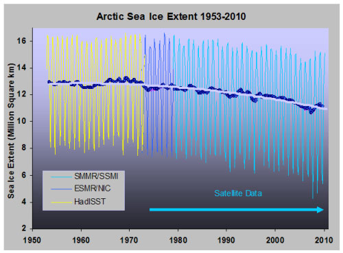
Figure 1: Sea ice extent with trend from 1953 onwards.

Sea ice extent gives us a reasonable indication of the amount of Arctic sea ice but does have its limitations. Extent tells us about the state of the sea ice at the ocean's surface, not what's happening below. A better metric for the total amount of sea ice is, well, the actual total amount of sea ice, measured by sea ice volume. Satellite radar altimetry (Giles 2008) and satellite laser altimetry (Kwok 2009) find that Arctic sea ice has been thinning, even in 2008 and 2009 when sea ice extent showed a slight recovery from the 2007 minimum. So while some claimed Arctic sea ice was recovering after 2007, the total volume of Arctic Sea ice through 2008 and 2009 were the lowest on record (Maslowski 2010, Tschudi 2010).

Arctic sea ice volume anomaly
Figure 2: Continuously updated Arctic Sea Ice Volume Anomaly Polar Ice Center.

Currently, websites such as Watts Up With That are using sea ice extent in 2010 to claim Arctic sea ice has returned back to normal. A few days ago, Watts claimed that we had "more ice than any time on this date for the past 8 years". On the contrary, in March 2010, the total Arctic sea ice volume was 20,300 km3 - the lowest March value for total sea ice volume over the 1979-2009 period. Those who claim Arctic sea ice has returned to normal are focussing at the thin shell at the top and neglecting the steadily thinning sea ice below.

UPDATE: This post is actually the intermediate version of the Arctic sea ice argument. I posted the wrong version! I've just published a new blog post featuring the Basic version. Sorry for the confusion, especially to Graham.

Note: This post is the Basic version (written by Graham Wayne) of the skeptic argument "Arctic sea ice has recovered". We're currently going through the process of writing plain English versions of all the rebuttals to skeptic arguments. It's a big task but many hands make light work. If you're interested in helping with this effort, please contact me

0 0

Printable Version  |  Link to this page

Comments

Comments 1 to 13:

  1. I'm thinking that this post should be revised to show the most recent data (you're missing a massive dip in ice volume) and WUWT is no longer arguing we are recovering but just that it won't be the least on record. An interesting link to see is here: http://arctic.atmos.uiuc.edu/cryosphere/NEWIMAGES/arctic.seaice.color.000.png The Northwest passage is officially open.
    0 0
  2. I'd agree with Robert's comment on using the latest data. At least you should swap the "A few days ago" to "In April 2010", so that the post remains relevant when people are reading in in weeks, months and years hence. Showing the latest PIOMAS volume anomaly data is also instructive. When the anomaly hits -13.4 in September of any year that means there's no ice left that September. This year the anomaly is currently (in August) just above -10, or off the bottom of your chart above. You can spread 6,000km^3 of ice to cover a remarkably large area of ocean, but you cannot spread 0km^3 to cover the same area...
    0 0
  3. I'd agree that date wording should be absolute rather than relative (e.g. 'August 2010' rather than 'this month'), but including the latest data and studies in the 'Basic' versions would seem to make them more precise than the 'detailed' copies in some cases. Thus, I'd suggest keeping the same charts and references until it is possible to update all copies.
    0 0
  4. Yes, keep the post in the context in which it was written by using absolute dates. Not only is the NW Passage open, but so is the Northern Passage (the other side of the Arctic Basin). The Russkies just passed a 100,000 ton tanker through it with icebreaker support, while there's a norwegian team trying to circumnavigate the arctic. They've already passed through the narrowest point (from the ice cap to land) and are working their way over to the NW Passage, and barring mishaps should get there in plenty of time to sail through it before it begins to refreeze. That would be a first ...
    0 0
  5. Anyone wanting to see the open passage can look here: http://arctic.atmos.uiuc.edu/cryosphere/NEWIMAGES/arctic.seaice.color.000.png
    0 0
  6. "The Northwest passage is officially open." Most depressing opening ceremony in a long time.
    0 0
  7. Count me in agreement that the volume anomaly chart should be adjusted to show the current minimum anomaly. WRT to the title of this post, skeptics think in 2 dimensions because they never saw the movie. The Yooper
    0 0
  8. #7: "skeptics think in 2 dimensions because they never saw the movie." That's a hoot! But we should be thankful: 2 dimensions is better than the usual one D thinking that you see all over denier sites about the IARC-JAXA graphs. "The decline in extent during July (i.e. the June 30th extent minus the July 31st extent) was uncommonly low." See, you can make a silk purse out of a sow's ear.
    0 0
  9. Surely both measurements are important for different though related reasons. Decline in volume causes average thickness of sea ice to diminish and the speed with which it melts, so it effects the duration of ice cover. Decline in the extent of ice cover reduces its effectiveness in reflecting solar energy back into space, limiting ability of the Arctic Ocean to absorb it. It is the latter aspect we should be concerned about since loss of the albedo effect means that solar energy absorbed by seawater is gradually increasing, warming that water, further reducing the thickness, extent and duration of sea ice cover.
    0 0
  10. To be fair it's not just skeptics that favour extent and area it's the scientists themselves. Every online website from polar groups seems to have it's own measure of extent. In fact PIOMAS ice volume graph you show is a fairly unique online metric from my trawling. While PIOMAS seemed accurate before 2007 there does seem to have been a deviation between their modelled results and reality since. In 2008 and 2009 this model underestimated the minimum extent and looks like it will again underestimate extent. Surely a model is always under scrutiny going forward, this is the best test for how well it is modelling the real world, at what point do we say that a model is no longer accurate. It seems that continually referring back to 3 years when it matched well with a short satellite data set can't be enough to keep it afloat. There are still issues with ice thickness measurements specifically the lack of good spatial and temporal coverage which leaves uncertainty in any estimate of volume or trends. Looking back to the 1990's here's two papers covering that period which came to very different conclusions (Windsor and Rothrock). More recently I just read this paper Thickness sensitivities in the CICE sea ice model Elizabeth C. Hunke Ocean Modelling Volume 34, Issues 3-4, 2010, Pages 137-149 which suggests that the probable number of factors which affect ice thickness out-numbers the data sets by which those factors can be constrained suggesting we still don't have the data by which we can directly or through models accurately estimate thickness and more importantly trends. It seems there are good reasons why some are cautious about ice thickness. Why not highlight the uncertainty associated with this particular metric? It seems like an important aspect of the work. (Just for correction the Giles 2008 and Kwok 2009 only seem to cover 2008 data not 2008/2009 as you seem to suggest in your article. You've also managed to leave out the word modelled with regard to the PIOMAS graph.)
    0 0
  11. I second the comments at #9. And also the concern for whether this post will date quickly (especially since it already refers to April and it is August). I thought basic level explanations were generally not going to include links to papers. Furthermore, I wonder about the register of "metric" and "satellite radar altimetry" in a basic level explanation. I think Graham does a great job, but a couple of improvements are possible in this one.
    0 0
  12. Agnostic #9: Actually, extent does not DIRECTLY relate to albedo. Ice extent is the area of OCEAN containing at least X% (usually 15%) sea ice. So, an extent of 100 sq km might only have 15 sq km of actual ICE area. That said, there are actual ice AREA estimates as well and those are obviously relevant for albedo purposes. However, I still think volume is the most important factor to keep an eye on. If it continues dropping at the rate it has the past few years (unlikely) then we're only three or four years from all the ice being gone. More plausibly volume declines will level off in the next year or so once all of the multi-year ice has melted down to basically the same thickness as 'first year' ice. It'll be interesting to see how quickly that leads to the breakup of the mass of multi-year ice along the northern Canadian archipelago (the western fifth is already gone) and what that will do to Arctic currents and ice export.
    0 0
  13. Ah, thanks for the clarification. That makes much more sense!
    0 0

You need to be logged in to post a comment. Login via the left margin or if you're new, register here.


The Consensus Project Website

THE ESCALATOR

(free to republish)


© Copyright 2024 John Cook
Home | Translations | About Us | Privacy | Contact Us