


 Arguments


What is the significance of the Great Lakes temperature as measured by satellites?
What the science says...
Satellite error inflated Great Lakes temperatures
"Global warming data apparently cooked by U.S. government-funded body shows astounding temperature fraud with increases averaging 10 to 15 degrees Fahrenheit. The tax-payer funded National Oceanic and Atmospheric Administration (NOAA) has become mired in fresh global warming data scandal involving numbers for the Great Lakes region that substantially ramp up averages." (John O'Sullivan)
There are a variety of rumors involving claimed problems with satellite temperature measurements. Unfortunately, there is a great deal of confusion on this point. Here are the main points:
- These stories were sparked by image maps of surface temperatures for the US/Canada Great Lakes posted by an automated processing system at the NOAA-funded Great Lakes Coastwatch program website. In areas with full or partial cloud cover, these maps sometimes show obviously erroneous temperature estimates over the lakes.
- There is a great deal of confusion about whether this represents a broader problem with satellite temperature measurements, and perhaps "invalidates" the satellite temperature record.
Are the Great Lakes Coastwatch data used in any of the global mean temperature records?
First off, the Great Lakes Coastwatch data products aren't part of any global climate data set. They are produced by a local team of investigators supported by the Michigan Sea Grant program and NOAA's Great Lakes Environmental Research Laboratory (GLERL), and are primarily used by fishing vessels, natural resource managers, and scientists with an interest in the Great Lakes.
The images posted at the Great Lakes Coastwatch site come from an automated algorithm that assimilates thermal infrared imagery from the Advanced Very High Resolution Radiometer (AVHRR) instrument on NOAA's Polar Orbiting Environmental Satellite (POES) constellation. Where clouds are present, the temperature measurements are not reliable, and the algorithm flags these areas with black or gray tints on the maps to indicate this uncertainty.
It's important to note immediately that these data have no connection whatsoever to the main global satellite temperature records, which are produced by researchers at Remote Sensing Systems (RSS) and at the University of Alabama at Huntsville (UAH). Those data sets come from measurements by different sensors entirely, operating in the microwave portion of the electromagnetic spectrum, rather than the thermal infrared range used by AVHRR.
The Great Lakes Coastwatch data are likewise not merged with any of the global mean temperature records produced by NASA, NOAA, the University of East Anglia, the Japanese Meteorological Agency, or others.
So, to allay people's fears, none of the Great Lakes Coastwatch data are used in any global temperature reconstruction, and the primary satellite temperature trends don't even come from the same sensor or the same portion of the electromagnetic spectrum. Conflating the two data sets isn't just like confusing apples and oranges, it's like comparing apples and salmon, or apples and lettuce (or pick any two completely unrelated food groups of your choice).
Implications for sea surface temperature measurements elsewhere
That said, data from AVHRR are used as one (among many) sources used to measure sea surface temperatures (SST). Do the errors in some of the Great Lakes Coastwatch images indicate potential problems for SST data sets elsewhere?
There is a particular concern about the status of the AVHRR instrument on the NOAA-16 spacecraft. The stories circulating in the skeptic blogosphere this week generally don't recognize that NOAA-16 is a "secondary" satellite in the POES constellation, that AVHRR is present on other satellites, and that there are additional sensors on other US and international spacecraft with similar wavelength ranges in the thermal infrared range that are used for sea (or lake) surface temperature measurement.
Satellite thermal infrared measurements of sea surface are one of the most important global weather and climate records, and are used for everything from tropical storm prediction to fishing vessel operations. These data are provided by different sensors on multiple spacecraft, and are continuously validated using in-situ temperature measurements from buoys and ships.
In summary
Stories in the "skeptic" blogosphere recently have given their readers a mistaken impression that there are reasons to question the validity of observed warming in the various satellite-derived global climate data sets. This is not the case.
The cited examples of temperature errors in the Great Lakes region are not incorporated in any of the global mean temperature records. In particular, there is no connection to the satellite microwave temperature analyses by RSS (Figure 1) and UAH, which use entirely different sensors operating in a quite different portion of the electromagnetic spectrum.
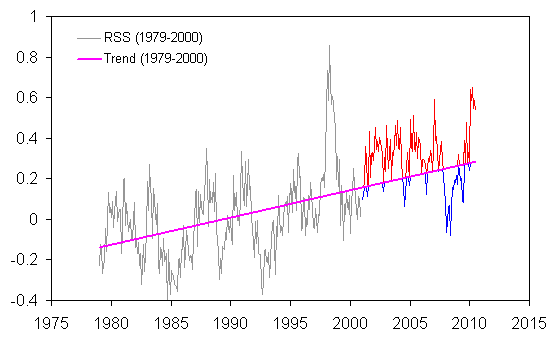
Figure 1. RSS (satellite-derived) monthly temperatures through 2000 (in gray) and 2001-2010 (red and blue). The pink trendline is the linear trend 1979-2000.
Last updated on 2 September 2010 by Ned.


Climate Myth...