RSS Posts   RSS Posts
RSS Comments   RSS Comments
Subscribe by Email   Subscribe by Email

Find out about our iPhone app...

Support Skeptical Science:


Username
Password
Keep me logged in
New? Register here
Forgot your password?


It's the sun
Climate's changed before
There is no consensus
It's cooling
Models are unreliable
Temp record is unreliable
It hasn't warmed since 1998
Ice age predicted in the 70s
We're heading into an ice age
Antarctica is gaining ice
View All Arguments...


Latest Posts

Archives


Sunday, 30 November, 2008

Latest satellite data on Greenland mass change

I've just updated the Greenland is losing ice page as a new paper analysing satellite data on Greenland mass change has been released (Wouters 2008). The Gravity Recovery and Climate Experiment (GRACE) measures changes in the Earth's gravity field and found that from February 2003 to January 2008, Greenland lost mass at a rate of 179 Gigatonnes per year. This is equivalent to a global sea level rise of 0.5mm per year. The rate is also increasing over time, suggesting an acceleration of mass loss.


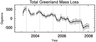
Figure 1. Time series of the monthly GRACE data between February 2003 and January 2008, for the entire Greenland ice sheet.

Figure 1 shows that mass builds up slowly between October and April, followed by rapid loss of mass between May and September. The vertical dashes indicate the middle of May, roughly coinciding with the start of the summer seasons. The paper also compares mass changes in regions below 2000m (eg - coastal regions) with the Greenland interior (above 2000m).


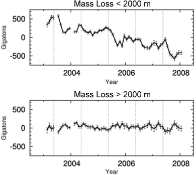
Figure 2. Time series of the monthly GRACE data for regions below 2000 m (top) and regions above 2000 m (bottom).

The interior of Greenland (>2000 m) shows a statistically insignificant positive trend of 7 ± 18 Gt/yr and appears to be in mass balance. It's worth noting that periods of mass loss above 2000 m are generally accompanied by accumulation below 2000 m.

So what we see is the Greenland interior is in mass balance but losing mass around the coastal regions. This equates to an overall mass loss. On average, Greenland contributed 0.5 ± 0.1 mm/yr to global mean sea level rise between 2003 and 2008. Trends are increasingly negative, partly due to the record mass loss during the summer of 2007, when mass loss occurred also at high elevations.

Posted by John Cook at 19:02 PM

Printable Version  |  Link to this page

Comments

Comments 1 to 18:

  1. It would be interesting to see the graph enlarged and extended back beyond the Gakkel ridge event in 1999, and a comparison with NA current flow and temps.
  2. Thanks for keeping this excellent resource up to date!
  3. Mizimi
    Actually I would love to see it extended back to 1975, just before the current bout of tectonic activity.
  4. At face value, the graph suggests that there was a mass gain going on until quite recently, perhaps 2005. If so, this past couple of years doesn't seem like much to worry about.
  5. Wondering Aloud at 05:36 AM on 17 December, 2008
    While it isn't a big deal this statement
    "The rate is also increasing over time, suggesting an acceleration of mass loss." does not appear to be correct. (See below link) In addition I have wonderful video of our NASA friends telling us that the Maldives etc. would vanish by the year 2000. None of these claims made over the last 20 years appear one bit closer to coming true. Indeed in every specific instance they used sea level is down or land area is up. (Bangladesh) Maybe we should lay off this kind of claim.

    http://wattsupwiththat.com/2008/12/05/satellite-derived-sea-level-updated-trend-has-been-shrinking-since-2005/

    I recently saw a paper using the original data as opposed to the "corrected" data on sea ice extent that claimed it had been increasing over the last 30 years. I didn't buy that as significant either but it was far more convincing than the minipulated pseudo data we see too often.
  6. WA
    Philippe was kind enough to give me these links in the Arctic Ice loss thread:

    http://nsidc.org/
    http://nsidc.org/data/seaice_index/

    They show a good map of the polar region and the anomalies. Also Philippes recent comments there are of interest.
  7. I am not sure what this claim actually shows. I know the intent is to suggest evidence of global warming, but it really is such an isolated instance and not free from the impact of contaminating variables. Furthermore, it is such a limitd data set (time wise) that no one should make any conclusion about the global climate based on this information.

    Why would anyone bring this up as support, it seams like a grasp at straw.
  8. TruthSeeker -- presuming "this claim" to mean the data described above, you've got it completely ass backwards. Click on the link that John Cook provides in the first sentence. There you'll see that what John is providing is a check of the claims put forward by those arguing that AGW isn't a real problem. This isolated instance and short time scale phenomenon that you feel is confounded with too many other variables is an example of an argument AGAINST AGW. But not only that, the information John provides shows how even the short, isolated, confounded example chosen by deniers actually shows the opposite of what they claim. Talk about grasping at straw!
  9. #5 - Quietman: post the NASA video!
  10. Steve L
    #5 is WA
    NASA video ?
  11. Taking the rate of ice loss at 179Gtonnes/annum equates to around 162Gtonnes water, which would give 0.45mm sea level rise, about the increase indicated.
    Iceland has an estimated 250 x 10E6 km3 of ice, and if you do the sums, it will take 1400yrs to melt if the melt rate does not vary, and mean sea level would rise 0.62m.
  12. D'oh! Thanks Quietman -- WA: please post your NASA video.
  13. For 11 Mizimi, from Wikipedia:
    "Some scientists believe that global warming may be about to push the ice sheet over a threshold where the entire ice sheet will melt in less than a few hundred years. If the entire 2.85 million km³ of ice were to melt, it would lead to a global sea level rise of 7.2 m (23.6 ft).[2] This would inundate most coastal cities in the World and remove several small island countries from the face of Earth, since island nations such as Tuvalu and Maldives have a maximum altitude below or just above this number."
    You can't both be right.
  14. Sorry..that .62m should have been 6.2 including differences in water/ice volumes.
    To melt that amount of ice would require an enormous amount of energy..around 950 x 10E21joules and I don't see where that excess energy is going to come from in a time frame of a few hundred years.
  15. Ian Forrester at 05:02 AM on 13 January, 2009
    Mizimi could you please tell me where you got your information that Iceland has an estimated 250 x 10E6 km3 of ice? That seems rather unusual since Greenland only has 2.85 million km³ of ice.

    Also can you explain where the missing 17 Gtonnes of H2O disappears to when 179 Gtonnes of ice melts? I would have thought that a ton of ice would melt to give a ton of water.
  16. Oh dear, I missed that Mizimi was writing about Iceland and not Greenland. Mizimi, please answer Ian's questions about where you're getting your info. Looks unreliable!
  17. Abject apologies to all....I plead
    a)temporary insanity
    b)Failing eyesight
  18. Maybe strike the 'temporary'

    #15 there is no mass loss but a change in volume as water is denser than ice.

Post a Comment

Political, off-topic or ad hominem comments will be deleted. Comments Policy...

You need to be logged in to post a comment. Login via the left margin or if you're new, register here.

© Copyright 2010 John Cook Links | Translations