Climate Science Glossary

Term Lookup

Enter a term in the search box to find its definition.

Settings

Use the controls in the far right panel to increase or decrease the number of terms automatically displayed (or to completely turn that feature off).

Term Lookup

Settings


All IPCC definitions taken from Climate Change 2007: The Physical Science Basis. Working Group I Contribution to the Fourth Assessment Report of the Intergovernmental Panel on Climate Change, Annex I, Glossary, pp. 941-954. Cambridge University Press.

Home Arguments Software Resources Comments The Consensus Project Translations About Support

Twitter Facebook YouTube Mastodon MeWe

RSS Posts RSS Comments Email Subscribe


Climate's changed before
It's the sun
It's not bad
There is no consensus
It's cooling
Models are unreliable
Temp record is unreliable
Animals and plants can adapt
It hasn't warmed since 1998
Antarctica is gaining ice
View All Arguments...


Username
Password
New? Register here
Forgot your password?

Latest Posts

Archives

September 2010 Arctic Ice Extent Handicapping Via ARCUS

Posted on 24 June 2010 by Doug Bostrom

Guest post by Doug Bostrom

Unusually low ice cover in 2007 galvanized public attention on Arctic sea ice extent and ever since, discussion at climate-related web sites has raged back and forth on what portends for future Arctic ice behavior. While the trend of sea ice extent seems clear and meanwhile attention has swerved increasingly to ice volume as a better diagnostic of Arctic ice status, all the same everybody's fascinated with weather and what's going to happen next and this year's ice behavior is no exception. The SEARCH division of the Arctic Research Consortium of the U.S. (ARCUS) has gathered and released an informal set of prognostications on the fast-approaching Arctic sea ice minimum for this year.

In all, SEARCH mustered 16 opinions and predictions about this upcoming September's results, spanning the gamut of authors from interested laypersons to the highly expert. SEARCH summarizes:

”The June Outlook for arctic sea ice in September 2010 shows reasonable arguments for either a modest increase or decrease in September 2010 sea ice extent compared to the last two years (5.4 million square kilometers in 2009 and 4.7 million square kilometers in 2008). However, it is important to note that the June 2010 Outlook indicates a continuation of the overall trend in long-term loss of summer arctic sea ice, with no indication that a return to historical levels of the 1980s/1990s will occur.

Reasoning for an increase in sea ice extent from recent years assumes that the current presence of extensive second- and third-year sea ice that we saw in winter 2009/2010 indicates a build-up of multi-year sea ice and a more stable ice pack. Reasoning for a decrease in sea ice extent from recent years, perhaps approaching new record-low minimum, focuses on the below-normal sea ice thickness overall, the thinning of sea ice in coastal seas, rotting of old multi-year sea ice, warm temperatures in April and May 2010, and the rapid loss of sea ice area seen during May.”

Presented graphically, the distribution of predictions:

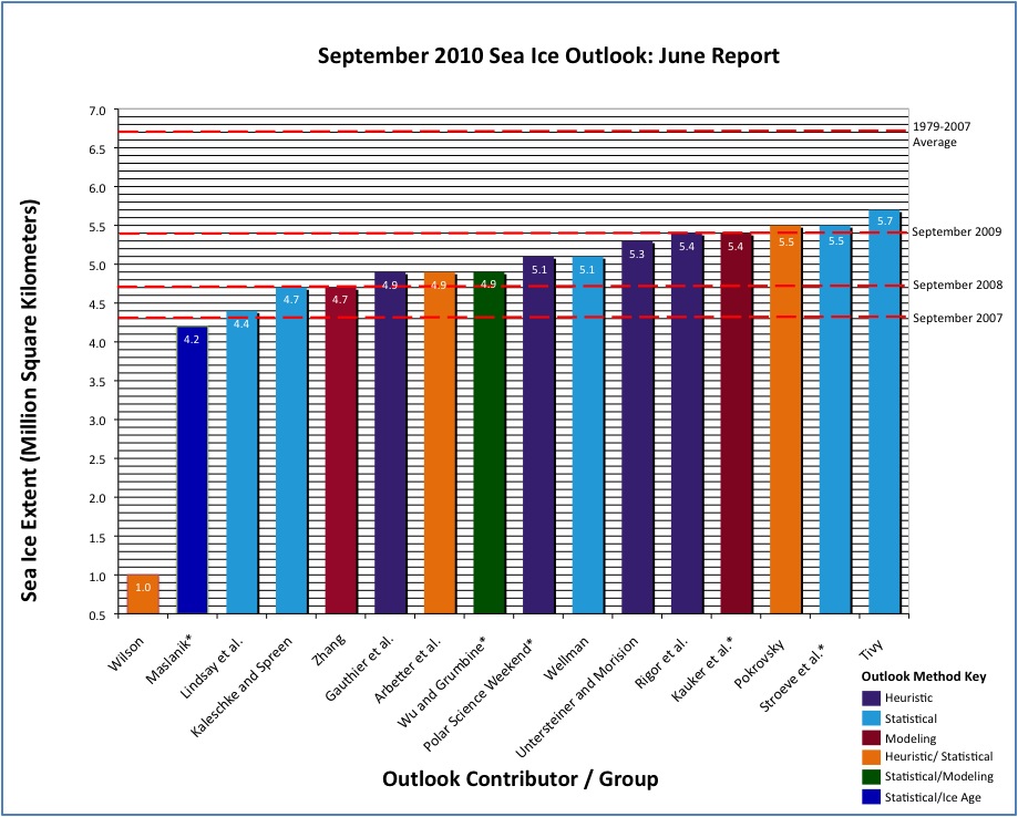
Quite a reasonable clustering on the whole, although on the left side you can see a lonely outlier. SEARCH welcomes unsolicited submissions to this report if they meet certain easily satisfied requirements, a nice gesture of inclusiveness. That dramatically low estimate is from such a participant, a prediction we hopefully and most likely won't see verified come September.

The other prediction of particular interest for us typically average folks is that of the “Polar Science Weekend “ sponsored by the University of Washington and Seattle's Pacific Science Center. Members of the lay public visiting an exhibit on the polar regions back in February were invited to make predictions after learning some basics of Arctic sea ice and participating in a discussion. PSW describes the results:

We had a total of N = 60 guesses from about six hours of discussions. The mean was 5.1 million square kilometers and the standard deviation was 2.15 million sq km. The mean is quite near that predicted by the trend line (5.15 +/- 0.57 million sq km), but the spread is greater.

Good job, Public!

Full details on the philosophies and methods behind all the predictions as well as affiliations of contributors may be found here (pdf).

0 0

Printable Version  |  Link to this page

Comments

1  2  Next

Comments 1 to 50 out of 80:

  1. All in all, I'm not a huge fan of prognostication. I'll wait until September to see the *real* results ;). Either way, it certainly looks like below average ice-cover is here to stay!
    0 0
  2. Marcus at 11:45 AM on 24 June, 2010 "Either way, it certainly looks like below average ice-cover is here to stay!" Hate to quibble about semantics Marcus, but below average ice-cover is not here to stay. It will simply disappear all together.
    0 0
  3. Have Goddard sign up.
    0 0
  4. Do we know when the more scientific prognostications were done. Right now an ice extent of 4 million square km looks about right, yet early May I might have guessed a higher figure. Exactly when the summer ice goes is now a matter of weather.
    0 0
    Moderator Response: The deadline for submissions was May 31 so it's fairly safe to say the work was done in May.
  5. Wilson prediction is hmm... strange :)
    0 0
  6. Wilson does go a bit off the tracks, especially the bit where we learn of Destruction of nearly ALL aboveground structures North of 10 Degrees Latitude = 99% Deaths in USA, Europe, etc. within 2 years. Fortunately he only assigns a 1 in 8 chance of that happening so we'll probably make it through this year, at least. Honestly, it's a remarkable thing for SEARCH to include lay opinions, a noble impulse but one I think might get out of hand. At the very minimum we might need much wider browser windows if predictions end up numbering in the hundreds. The methods part of the collection is in fact quite interesting, a smorgasbord for sea ice mavens.
    0 0
  7. Also note that these predictions will be updated monthly through the Summer. Thus, they're likely working on new results for the June 30 deadline now. I expect that means most of them will be adjusted downwards... given that we're now roughly twice as far below the long term average as we were at the end of May.
    0 0
  8. "Have Goddard sign up." Earlier Goddard had said it would "recover" to the 2006 level, 5.8+. Now he's saying 5.5 and is claiming he never predicted 5.8, because as he puts it, "5.5 is the first numerical estimate I've made" (i.e. saying "same as 2006" doesn't count because he didn't append " which was 5.8" to the sentence). But posters there are holding him to the 5.8 number. We shall see.
    0 0
  9. I'm thinking between 5.0 and 4.5, maybe 4.25, bracketing 2008. Not that I can base that on anything more sophisticated than looking at the IARC-JAXA multi-year plot and the PIOMAS volume model, mind.
    0 0
  10. Considering how low the ice concentration looks as compared to prior years I'm gonna be bold and guess a new record low at 3.9. Frankly, from that map, it looks like everything could melt out except a roughly triangular blob anchored across the northern edge of Greenland and Ellsmere Island and stretching northwards towards Severnaya Zemlya.
    0 0
  11. @dhogaza "Earlier Goddard had said it would "recover" to the 2006 level, 5.8+." Source?
    0 0
  12. Steven Goddard writes below that he agrees with the prediction I made in late 2009 that we’d see another 500,000 km2 of Arctic sea ice recovery in 2010. My analysis indicates the highest late summer extent since 2006. And then finally 2 days ago: I’m forecasting a summer minimum of 5.5 million km², based on JAXA. i.e. higher than 2009, lower than 2006. For a timeline of WUWT antics, read my blog post over at the Arctic Sea Ice blog.
    0 0
  13. Goddard-trackers ought to check out Neven's piece, if nothing else for the writing which is simultaneously entertaining, concise and dense with information, thereby assisting the reader through a thicket of arcana. No mean feat. Is it any wonder newspapers are dying? How can any general-circulation print organ keep up with the likes of folks such as Neven?
    0 0
  14. Compare the two animations carefully. What can you see inside the arctic basin?
    0 0
  15. Too bad it's too late for "official" predictions. However, it seems clear enough now from the mobility of the ice flows, that this will be record low year. So, I'll say it be as much as 1 million km^2 less than 2007. That will put it in a range between 3.3 to 4.3 million km^2; 3.8 for an average.
    0 0
  16. Thanks, Doug. I figured a summary of WUWT Arctic sea ice chest-thumping could prove to be helpful in case we get a new record. It's a dirty job, but someone's got to do it. ;-)
    0 0
  17. Squint hard enough and you can see whatever you want. Frolicking polar bears, submariners with Mai Tais, whatever. That GIF is using 2% of my CPU. BP, you're increasing my carbon footprint.
    0 0
  18. That GIF is using 2% of my CPU. BP, you're increasing my carbon footprint. Go to the PIPS webpage and hear your CPU fan spin up (because of the snow effect in the background). :-) Peter, maybe you can add a ice thickness colour index.
    0 0
  19. It appears that SEARCH have been gathering Sept minima for 3 years. Fortunately they archive the 2008 AND 2009 predictions. A similar clustering occurred in both those years unfortunately all predictions underestimated the actual ice extents. So the clustering this year does not necessarily indicate were the final extent will be. I can't help thinking that the extraordinary ice extent in 2007 is in some way playing through these prediction methods to give a low bias. If it's not this I'd love to know what's causing this bias? On a side note. The recent WUWT ice discussions have largely centred around the skill of PIPS v2 and PIOMAS to predict ice volume. PIPS don't seem to have submitted predictions to SEARCH but PIOMAS have (in the shape of Zhang et al). The PIOMAS predictions for 2009 seem particularly poor giving the 2nd worst prediction in May and 4th worst in June. I see from Doug's article Zhang is on the low side for 2010 again.
    0 0
  20. HR, thanks for calling those past predictions to our attention. I should have included those but confess I did not dig back to find 'em. What we know of human nature suggests that it would indeed be difficult to entirely isolate our psychology from the 2007 surprise. For my part I remain impressed by the "Joe Public" prediction, particularly as it was made in February. I'd love to see a breakout of the distribution but it's not in the supporting materials.
    0 0
  21. I should just point out 2008 predictions weren't as bad as 2009. 11/14 underpredicted the ice extent (3/14 overpredicted) but there still seems a bias towards low predictions.
    0 0
  22. It's not so surprising, considering the fact that 2007 took everyone completely off guard. Had the weather conditions of 2008 and 2009 come anywhere near those of 2007 the record would have been broken again. The same goes for this year. The ice in the Arctic Basin has perhaps recovered somewhat, but it is irrelevant if we get 2007 weather conditions.
    0 0
  23. Given were all in baseless prediction mode I'll give it a go. I'm going to agree with 14 Berényi Péter and disagree with 10 CBDunkerson that the central Arctic Ocean ice is looking better through this winter than the past few years. I think the archive data from Cryosphere Today also suggests this. I think people here were right in previous discussions that the greater ice accumulation at some parts of the periphery this winter was destined to quickly melt as witnessed by the steep decline over the past few months. So I predict through the summer the melt will slow more quickly than previous years due to the better central Arctic ice and we'll end up somewhere near the 30year trend average plus a few tenth of a million sq km because I'm an optimist. So I'll go with 5.4 I also predict that PIOMAS will underestimate again this year.
    0 0
  24. 22 Neven So what you're suggesting is it's all down to the weather?
    0 0
  25. Of course it's all down to weather, but it's the preconditioning (or thinning if you will) of the ice that makes the influence of different weather patterns relevant. In the 80's there were also freak years like 2007, but because the multiyear ice was so thick, the minimum sea ice extent easily stayed above, what was it, 8 million square km. I've also written a piece on the Cryosphere Today archive data and the discrepancy with the daily ice concentration map on the front page. No conclusions, unfortunately, but the archive maps look fishy to me. BTW, one of the NOAA webcams stationed at the North Pole seems to be showing a first melt pond.
    0 0
  26. Given that the ice sheet extent is on track to dip below the record low Sept/Oct 2007 levels that caused panic at the IPCC, you folks are showing admirable restraint. Nobody is going ape s**t. As usual BP is way above my pay grade but I will keep coming back in the hope that my grey cells will improve.
    0 0
  27. Panic at the IPCC? The IPCC is like 50 years behind the current trend. No, the IPCC is much too skeptic on this point (and on sea level rise). I have passed the phase of apeshit. I don't the envy all the people who still have it in front them. I had several years to digest it. ;-)
    0 0
  28. "Sept/Oct 2007 levels that caused panic at the IPCC". Reference please for this "IPCC panic". However the rate of decline in ice is getting well beyond IPCC predictions so it is a cause for concern if it persists.
    0 0
  29. Further to HR's thoughts about psychological influences on predictions, I took a closer look at the rationales and methods described in the supporting material for the SEARCH collection. With the exception of Wilson and Wellman it's hard to see where the psych angle fits in. I suspect the undershoots have a lot to do w/the statistical input to the various models in play but I don't have the chops to prove that, rather I'll just surmise that if the trajectory of past statistics is overwhelmed by variability expressing itself as an upswing the upshot would tend to be an undershoot. Doubtless the expert cohort in the SEARCH participants could help to clarify that.
    0 0
  30. #18 Neven at 11:37 AM on 25 June, 2010 Peter, maybe you can add a ice thickness colour index. Here you go. Current extent of ice thicker than 2 m in arctic basin is almost twice as much as it used to be last year, same date. Beaufort Gyre is working hard this year, ice thickness at its center is getting close to 4 m (due to ridging).
    0 0
  31. BP #14/30, why would the yellow spot forming in the Beaufort be indicative of HIGH extent this year? Essentially what is happening is that a large area of thinner ice is being compressed into a smaller area of thicker ice by the gyre. Given that extent is 'ice area / concentration' wouldn't decreasing area and increasing concentration serve to yield a LOWER extent? That said, I expect the yellow swathe will break up as the season continues. That's the kind of pressed together 'rotten ice' they've been finding which doesn't really have much solidity to it. As to the general premise of the arctic basin ice being thicker this year than last - there has been alot of dispute about that with different methodologies coming up with different thickness measurements. However, I don't think it is as significant as you suggest... from the rate of decrease on the map it seems very likely that all the ice now at 2.5 meters in thickness or less is going to melt (indeed by the end of the animation the only such ice left is a small band that previously was 3+ meters thick). If you then look at the 3+ meter ice on the last frame of that 2010 map you'll see that it covers roughly a triangular shape "anchored across the northern edge of Greenland and Ellsmere Island and stretching northwards towards Severnaya Zemlya"... in other words, precisely the section I predicted would NOT melt this year. So yes, there is a core of potentially thicker / more solid ice (though some studies seem to indicate it is thinner/weaker than aerial observations suggest) in the Arctic basin this year. But if that is all which survives the melt, as seems very likely, then we're still looking at a very low extent this year.
    0 0
  32. "Given that the ice sheet extent is on track to dip below the record low Sept/Oct 2007 levels that caused panic at the IPCC, you folks are showing admirable restraint. Nobody is going ape s**t." IPCC suggests that the arctic will become ice free in summers in the 2050-2100 time frame, hardly panic. If you want panic, note that those noted warmists Watts and Goddard recently predicted an ice free arctic by 2060. Much more pessimistic than the IPCC! Of course there's been a flurry of posts afterwards trying to live that down, since they were apparently under the misapprehension that the consensus date for an ice free arctic is 2013...
    0 0
  33. Some of those denialists spin more than a baby seal being tossed by an orca! http://legendofpineridge.blogspot.com/2010/06/george-monbiot-attacks-delingpole-spins.html
    0 0
  34. I wouldn't venture to any prognostic myself. Arctic sea ice is very weather dependent from year to year. Right now it is rather low and the decline since the max extent has been quite steep. But the summer decline is dependent on wind patterns perhaps more than anything else. If winds do not disperse the ice, it won't be carried away and melt. Prognostic is much of a gamble. All we can do is wait and see
    0 0
  35. HR: "I also predict that PIOMAS will underestimate again this year." Note that the Zhang prediction isn't entirely based on PIOMAS. Here is a link to the prediction page: http://psc.apl.washington.edu/zhang/IDAO/seasonal_outlook.html Also, Ron Lindsay (also at PSC) has his own prediction method: http://psc.apl.washington.edu/lindsay/September_ice_extent.html I find all of these predictions interesting, but not particularly helpful to the discussion of AGW because they distract from the data. The long-term trend is what is important. The predictions, while they serve a useful purpose for regional economic and environmental activities, give critics ammunition when they are wrong, as they often will be in an area with weather systems that are as variable as those of the arctic. The data alone make the case well enough. The long-term trends of arctic sea ice extent, area, and volume are downward, and that is very strong evidence of a warming arctic climate.
    0 0
  36. There will always be more multi-year ice when last summer did not melt as much as the second last. This is trivial. To have volume you have to combine thickness and ice extent or area. Trivial, again. Currently the arctic is (and has been for a month) at its record low in extent. If going toward the pole the ice is thicker than that found last summer it may slow down a bit. But if the increased thickness is due to ridging it may not happen, it cracks and melts more easily. I will not bet on next september minimum, too complicated to put a reasoned one. Considering the standard deviation of 0.5 MKm2 calculated from NSIDC data, I don't see much of a difference between the various estimates. But one thing seems likely, the lack of recovery after 2007 (as a trend, not a few years) will be confirmed.
    0 0
  37. "Currently the arctic is (and has been for a month) at its record low in extent. If going toward the pole the ice is thicker than that found last summer it may slow down a bit. But if the increased thickness is due to ridging it may not happen, it cracks and melts more easily." The thing I find interesting is that the cryosphere ice area calculation is dropping like a rock. It took a real step turn downwards a couple of weeks ago, while the extent estimates continue on roughly a linear pace. There are problems with melt ponds on top of the ice fooling the various ice measurement algorithms, but year-to-year comparisons should still be apple-to-apple. So it appears that not only is extent dropping rapidly, but there's more open water within the extent area compared to the last couple of years, due to recent acceleration of the decrease in area mentioned above. I still think 2008 < 2010 < 2009 but am prepared to be surprised on the low end. It's going to be a good summer to watch ice.
    0 0
  38. The daily images at Cryosphere Today come from the University of Bremen and are AMSR-E images. The comparison images look like the daily images at NSIDC, which are DSMP SSSM/I images. The AMSR-E images are supposed to be more accurate, but they often show melt ponds as open water. The cutoff for ice free is also different in the two images. If you compare the two they do not look the same on a single day. On the other hand, the comparison ap on Cryosphere Today shows two images from the same sensor so they are useful for comparing two different dates. It often does not work to compare two ice images from different sources. BP: I copied this letter from Goddard's blog at WUWT. Someone wrote the NSIDC and asked about PIPS data. As you can see, Dr. Meier thinks that you cannot use the PIPS data to determine ice volume as you have done. He says both the thickness and concentration are known to be inaccurate. PIPS data is not intended to be used to determine volume-- the scientists at PIPS do not make a claim of ice volume. WUWT likes to use this data because it seems to conform to their agenda, even though it is known to be inaccurate. On the other hand, PIOMAS data is intended to measure ice volume, and PIOMAS is at a record low. “Thank you for contacting NSIDC. Walt Meier, one of our sea ice scientists provided some thoughts which I will sum up along with a few other points from talking with other scientists here at NSIDC: Unfortunately, there are no continuous, Arctic-wide measurements of sea ice volume/thickness which is why models are used to estimate volume/thickness. Sea ice extent on the other hand is derived from remotely sensed data from satellites. The PIPS model is an operational model, and is designed to forecast the ice a few days into the future (for navy submarine use, etc). It is not proper to use it to study year to year changes. PIPS, is known to be not terribly useful for sea ice other than perhaps motion; definitely not thickness. Our assessment at ( http://nsidc.org/arcticseaicenews/) is based on (1) the ice age fields we get from data from our colleagues, Charles Fowler and James Maslanik, Colorado Center for Astrodynamics Research, University of Colorado Boulder, (2) models better suited to tracking thickness year to year, such as the University of Washington, PIOMAS model we’ve discussed in the past couple articles, and (3) consultation with operational ice centers that have very high quality data and human expertise at assessing the state of the sea ice. The PIOMAS model is looking back in time and estimating what the volume was in order to monitor trends. It has the benefit of “hindsight” and can incorporate actual recorded measurements (weather, satellite data etc.) that by nature are not available to make a forecasts. The most recent update of the PIOMAS model looks to be May 30th. Let me know if you have any more questions or need more information. Regards, Kara Gergely NSIDC User Services” here is the original blog post http://www.climat-evolution.com/article-banquise-arctique-pips-piomas-52419993.html
    0 0
  39. I predict a record low. Note how the ice is declining while the temperature is "inclining". Why should either of these things change much by September? Of course the current fast melt will run into some thicker ice. The winds associated with the very negative Arctic Oscillation reduced ice export through the Fram Strait last winter and caused a relative buildup of thicker ice. The same winds and surface driven currents kept the Arctic warmer than usual last winter. Watch the ice melt. dhogaza: "It's going to be a good summer to watch ice." I totally agree.
    0 0
  40. Quite a fracture developing upstream from Nares Strait, between apparently shorefast ice attached to N Greenland, and a soup of floes that looks like it all wants to float south. Looking at past years' NSIDC minimum maps, I didn't see open water in this area. Have features like this long fracture been common, or is it something new?
    0 0
  41. I've put 21 June 2002-2009 PIPS2 images along with smallest extent for each year. Plus 21 June, this year. It does not look worse than any one of them, except the stripe of old extremely thick ice on the western side is gone.
    0 0
  42. BP #41, how are you defining 'worse'? The 2010 June extent is the lowest of the bunch... and in that sense it is "worse" than ALL of them. Presumably you're still concentrating on the green/yellow/red mass in the Arctic basin... but that doesn't look any larger than it was at this point in 2007 (though the shape is different). It is also CLEARLY much smaller than it was in 2002-2005, especially 2004. All these predictions are, of course, contingent upon the weather. In truth anything between 3 and 6 could happen depending on what the weather does. However, we are currently at both the lowest extent and fastest rate of decline on record for this time of year. That perforce means that unless conditions change significantly we're looking at a low extent this year.
    0 0
  43. BP:
    It is not proper to use it to study year to year changes. PIPS, is known to be not terribly useful for sea ice other than perhaps motion; definitely not thickness.
    I'm curious as to what about this statement is so difficult to understand.
    0 0
  44. The "tape" graphic from Cryosphere is significant, IMO. This year is the first year there has been such a precipitious drop this time of year. As Neven pointed out, the June daily melt rate has been the highest on record and the melt season is only beginning. The chart is the NH Sea Ice Anomaly, the sentre line is the 179-2008 mean.
    0 0
  45. As an (ex) biologist who's followed the arctic ice situation with interest for a couple of years I'm somewhat perplexed that while a number of comments have emphasised the crucial importance of weather patterns in determining the eventual ice melt this year (eg #25 Neven "Of course it's all down to weather...."), no-one has mentioned that globally the first months of this year have been the warmest on record, or that record high temperatures have been recorded in country after country recently. It would surely be paradoxical if the increased heat energy in the earth's system does not have at least a modicum of influence on arctic weather over the next couple of months, and thus on the eventual ice minimum. For example, Weather Canada is predicting that Resolute, Cormwallis Island, will experience *night* temperatures in excess of the average daytime values for an extended period this week as a result of hot air being dragged up from far down in the US Great Plains. Is this common (I don't recall this happening last year) or are arctic weather patterns immune to what's happening in the rest of the world?
    0 0
  46. a_yeeles #45: "...or are arctic weather patterns immune to what's happening in the rest of the world?" Actually, temperatures in the Arctic have been further above normal than any other part of the world. The map below shows anomalies for May, with red being warmer than normal and blue being cooler;
    0 0
  47. Several of the SEARCH predictions mentioned the amount of second and third year ice present north of Alaska. The first year ice there has mostly melted out now. In the next few weeks we will see if the older ice holds out against melt, or if the reports of rotten older ice last year turn out to be important. The sea ice melt is such a fast event for global climate that is is easy to watch closely.
    0 0
  48. "... or if the reports of rotten older ice last year turn out to be important." As a_yeeles says, the heat is important. BTW, watch for new information Tuesday.
    0 0
  49. CBDunkerson #46 "Actually, temperatures in the Arctic have been further above normal than any other part of the world." Precisely. Which is why, as AMSU-A shows global temperatures continuing to track well above average, an exceptional arctic ice season may well be in prospect. ( http://discover.itsc.uah.edu/amsutemps/execute.csh?amsutemps )
    0 0
  50. Oops, sorry Link should be http://discover.itsc.uah.edu/amsutemps/ Apologies
    0 0

1  2  Next

You need to be logged in to post a comment. Login via the left margin or if you're new, register here.


The Consensus Project Website

THE ESCALATOR

(free to republish)


© Copyright 2024 John Cook
Home | Translations | About Us | Privacy | Contact Us