The Pacific Decadal Oscillation and global warming
Posted on 15 September 2010 by Nicholas Berini
The skeptic argument “it’s Pacific Decadal Oscillation (PDO)” suggests that maybe the true cause of recent warming is the PDO. The PDO is a climate phenomenon that occurs primarily in the North Pacific Ocean. The “oscillation” happens between warm phases (positive values) and cool phases (negative values) that last anywhere from 10 to 40 years. The phases are associated with changes in sea surface temperatures (SST). While the causes of the PDO are still unknown, the primary effects seem to be changes in northeast Pacific marine ecosystems and a changing jet stream path.
Important to note, however, is that the phases are not set in stone; there are frequently short sets of 1-5 warm years during a cool phase and vice-versa. Secondly, the “warm” and “cool” phases are less descriptive than they would appear. The cool period, for instance, is actually associated with extremely high sea surface temperatures in the Northern Pacific (see image below).
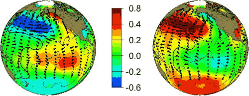
Figure 1: PDO warm phase (left) and cool phase (right). Image courtesy of JISAO.
One way to test this skeptic theory is to plot the Global Temperature Anomaly alongside the PDO Index (shown below). What we find is that although the PDO index appears to influence short-term temperature changes, global temperatures have a distinct upward trend, while the PDO Index does not.

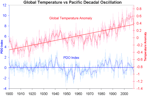
Figure 2: Pacific Decadal Oscillation index (blue, University of Washington) versus Global Temperature Anomaly (Red - GISS Temp). Smoothed data (thicker blue and red lines) and trend lines (thick straight line) are added.
Natural oscillations like PDO simply move heat around from oceans to air and vice-versa. They don't have the ability to either create or retain heat, therefore they're not capable of causing a long-term warming trend, just short-term temperature variations. Basically they're an example of internal variability, not an external radiative forcing. If PDO were responsible for warming the surface, the oceans would be cooling, which is not the case.
These results are expected. The long term warming trend is a result of an energy imbalance caused primarily by an increase of greenhouse gases in the atmosphere. In contrast, the PDO is an internal process and does not increase or decrease the total energy in the climate system.
This post is the Basic version (written by Nicholas Berini) of the skeptic argument "It's Pacific Decadal Oscillation".

Arguments


Not surprisingly, he also claims on occasion that it's the Sun, it's a natural cycle related to deglaciation, and on top of that we're not warming at all. It's just urban heat island effect.
If anyone can tell me what, if anything, Miami plans to do to deal with 1 m. of sea level rise by 2100, please contact me off-list at huntjanin@aol.com.
Back on topic...
McDonald & Case 2005
Variations in the PDO over the pas millenium
Can anyone speak to that?
From the header to the PDO data, "The monthly mean global average SST anomalies are removed to separate this pattern of variability from any 'global warming' signal that may be present in the data."
This one tripped me up so bad a while back that I emailed Nathan Mantua about it a year or so ago. It's unfortunately a common error, but it's still an error that should be corrected here.
If we compare with ENSO, for example, the Southern Oscillation Index is based on a comparison of sea surface temperatures in the eastern and western waters of the south pacific - by it's very nature, it removes any long-term warming or cooling trends, as presumably both areas are subject to the same long-term shift.
The PDO index, on the other hand, is defined as "average Pacific Ocean SST anomalies north of 20ºN". As there is no direct comparison with SST anomalies anywhere else, they define the "anywhere else" as the entirety of the world's oceans, so the PDO index is, in fact, a comparison of the north Pacific SST with the rest of the world's oceans.
On that basis, it's not so much "removing the trend", as providing an index that gives an idea of how the north Pacific is behaving compared to the rest of the world's oceans.
Otherwise, you'd have people arguing "See, the PDO is causing SST rise!", when the PDO would in fact be a measure of SST... or, in other words, "Global warming is caused by the oceans warming", which is an absurdly circular argument.
Confusion arises because of the difference between: 1) "Pacific Decadal Oscillation" (PDO), which is a generic term describing any multi-decadal cyclicity in temperature anywhere in the Pacific Ocean, and 2) "PDO Index", ("PDOI") which indicates the regionally averaged temperature of the Northern Pacific Ocean. The PDOI provides an indicator of the timing and cyclicity of the PDO.
Within the Pacific, however, are smaller-scale temperature zones that show temperature cycles occurring on the same cyclicity as the PDO, but having opposite trends!!!
PDO Index is defined as:
(Source: http://jisao.washington.edu/pdo/PDO.latest)
Thus, the PDO Index indicates the average temperature of the entire northern Pacific Ocean, normalized for the global increase in temperature. This trend (squiggly blue line) shows two broad cycles:
It is important to note that these trends describe the average temperature across the entire northern Pacific. When the data are gridded into individual cells, then contoured, this produces the colored patterns shown in the map above. Two "snapshots" are depicted... one representing a "Warm" phase, the other reprenting a "Cool" phase. (It's hard to say exactly what time period each snapshot represents.) In any case, this is where it gets a bit more confusing. In the "Warm" phase, the predominant trend is that of cool water across most of the northern Pacific. And the "Cool" phase is dominated by an extensive tract of warm water in the northern Pacific.
To understand the origin of the terms, you need to look at the water along the coasts of Alaska, extending downward into the Pacific Northwest (of the USA). You'll see that the water there is the opposite color of the predominant trend. Keep in mind that the point of the paper by Hare (1996) was to interpret the impact of the PDO on salmon fishery, so they were mostly considering the temperatures of the near-shore waters.
The important aspect of the maps, noted by John Cook, is that the water sloshes this way and that. Areas that are warm in one cycle tend to be cool in the next, and vice versa. There's no net impact on global warming. Or is there?!
The cool PDOI interval (My #3) corresponds to the broad decline in the rate of global warming seen in the red "Global Temperature Anomaly" trend, and the warm PDOI (My #4) coincides with the more rapid increase in the Global Temperature Anomaly... so while I don't believe that the PDO can account for the overall warming trend in the Global Anomaly, it's not inappropriate for skeptics to point out the correlation!
Given what else we know about the forcings during the 20th century, particularly the variations in solar irradiance, aerosols (see the next blog post), and CO2 concentrations, I think we can say it's most likely the latter - the PDO is affected by global temperature changes, even though it's generally neutral overall.
When you think about it, if the bulk of the extra heat is soaked up by the oceans, then it makes a lot of sense that this might result in significant changes in circulation patterns.
The relationship between Pacific Decadal and Southern Oscillations: Implications for the climate of northwestern Baja California., Pavia, 2009.:
“These results confirm that El Niño-Southern Oscillation (ENSO) forces the PDO.”
Professor Horst Malberg, analyzed ENSO and SOI in paper: La Niña - El Niño und der solare Einfluss, (Editor: Institut für Meteorologie - Berlin, 2009 - work is only available in German), write:
“Any temperature variation demonstrates the weakness of the working hypothesis of a dominant influence of anthropogenic CO2 effect on climate change. For the voiced suspicion that the anthropogenic greenhouse effect would be, if not before 1950, significantly influence at least after 1950, climate change, there is no real climatological evidence. Everything indicates that it is also in the last six decades by the IPCC in the postulated dominant CO2 greenhouse effect on global temperature change (warming) just a sham causality.”
The red and brown lines are temperature (from satellites & met stations, respectively).
The green lines are CO2 (ice core & atmospheric measurements).
The blue line is PDO.
The yellow line is solar irradiance.
Presumably, the observed temperature trend is the result of the interactions of all forcings, including those shown here and others as well. But this graph makes it clear that neither ocean oscillations nor solar irradiance is the dominant cause of the observed temperature trend since the 1970s. CO2 provides a much better fit. Adding in the effects of other greenhouse gases, and subtracting the effects of volcanic and anthropogenic aerosols, would make this match even closer.
--------------
The fine print:
PDO data from University of Washington. Surface temperatures from GISS land+ocean. Satellite temperatures from RSS. Law Dome CO2 from NOAA NCDC. Mauna Loa CO2 from NOAA ESRL. PDO and temperature data shown in monthly and 120-month LOESS smoothed versions. Law Dome CO2 dating based on "air age" with 20-year smoothing. Mauna Loa CO2 (monthly) are seasonally adjusted. Both CO2 data sets were log-transformed (base 2). Data sets with differing units (PDO, temperature, log[CO2]) have been scaled to fit on the same graph. Solar irradiance data from University of Colorado, shown annually and with a 22-year LOESS smoothing function.
Wow, that's quite the graph. The conclusions seem inescapable: when CO2 takes over as the dominant 'forcing', temps rise in a corresponding fashion. This took place in the late 70's-early 80's, matching the predictions made by Hansen et al., not in 1988, but in 1981.
If there isn't a Ned fan club, there should be!
As to Dr. Spencer's graph - that's another horror of bad data manipulation. He shows no evidence of removed CO2 (and other factor) forcings from his data; the warming is built in. He's also working with rate of change (the derivative) rather than total change; in any modeling system I know of that increases your noise considerably. Ned's graph is far more interesting, and I believe, more relevant to this discussion.
Nice chart Ned. Lots of work in that compilation.
Would it be possible to show us a similar chart of the areas under the TSI curve and the logCO2 curve with the correct vertical scale in Joules?