Climate Science Glossary

Term Lookup

Enter a term in the search box to find its definition.

Settings

Use the controls in the far right panel to increase or decrease the number of terms automatically displayed (or to completely turn that feature off).

Term Lookup

Settings


All IPCC definitions taken from Climate Change 2007: The Physical Science Basis. Working Group I Contribution to the Fourth Assessment Report of the Intergovernmental Panel on Climate Change, Annex I, Glossary, pp. 941-954. Cambridge University Press.

Home Arguments Software Resources Comments The Consensus Project Translations About Support

Twitter Facebook YouTube Mastodon MeWe

RSS Posts RSS Comments Email Subscribe


Climate's changed before
It's the sun
It's not bad
There is no consensus
It's cooling
Models are unreliable
Temp record is unreliable
Animals and plants can adapt
It hasn't warmed since 1998
Antarctica is gaining ice
View All Arguments...


Username
Password
New? Register here
Forgot your password?

Latest Posts

Archives

What's Happening To Tuvalu Sea Level?

Posted on 26 November 2011 by Rob Painting

Because the coral atoll of Funafati, Tuvalu is densely populated and generally less than 3 metres above sea level, this small island nation in the Pacific is often the subject of intense media speculation about the impact of rising seas. The atoll is likely to begin to be overtopped by the sea sometime between mid to late 21st century, however Tuvaluans have often featured in the mainstream media claiming to be already experiencing the detrimental effects of sea level rise. Scientific studies to support these claims has been have been hard to find, but now a recently published study vindicates what many Tuvaluans have insisted all along - sea level has risen rapidly around Tuvalu.

Becker (2011) has examined sea level rise in the western tropical Pacific Ocean using a combination of tide gauges, satellite-based measurements, ocean modelling and GPS, and found that the region is experiencing sea level rise much larger than the global average. At Funafati Island, the study authors found that between 1950-2009 'total' sea level, which also accounts for the rate of island subsidence or sinking, rose at 5.1 (±0.7) mm per year, almost 3 times larger than the global average over the same period.  

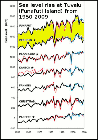
Figure 1- Sea level curves at tide gauge sites since 1950. Time series of reconstructed sea level (black), tide-gauge (red) and altimetry satellite in blue continue and in dash line (when tide gauge records were supplemented using altimetry data). From Becker (2011). Image cropped from original.

Sea level rise is not level

Of the many things about global warming misunderstood by the public at large, the irregular or lumpy distribution of sea level rise must surely be near the top of the list. When sea level rise is mentioned, this typically refers to the global average or mean, but this obscures the fact that not all areas of the ocean  are rising. In a few regions sea level is actually falling, while at others it is rising at a rate much larger than the global average. So even though the total volume of seawater from melting land ice, and thermal expansion from ocean warming are increasing, this isn't being evenly spread around the oceans. See figure 2 below.

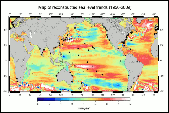
Figure 2 -Location map of the 91 tide gauges (stars) used in the global sea level reconstruction. The background map shows the sea level trends over 1950–2009 from DRAKKAR-based (an ocean model) reconstruction of sea level (uniform trend of 1.8 mm/yr included). From Becker (2011).

It just so happens that the western Pacific and Tuvalu in particular, are one such region where there is a large rise in sea level, much greater than the global average. See figure 3.


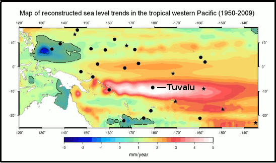
Figure 3 - Map of the Pacific Island region interannual sea level trend (linear variation with time) from the reconstruction 1950-2009. Locations of the 27 tide gauges (black circles and stars) used in the study are superimposed. Stars relate to the 7 tide gauges used in the global reconstruction. Dark areas relate to non-significant trends. From Becker (2011).

Mapping sea level rise in the western Pacific

Measuring ongoing sea global level rise, which results from the global warming-induced melting of land ice and thermal expansion, is a complicated business. This comparitively small long-term rise is often obscured because sea level can undergo large up-and-down fluctuations over seasonal, annual, and even decade-long time scales. This is especially true in the case of the islands of the western Pacific where the ENSO cycles El Niño and La Niña result in sea level fluctuations up to 20-30 cms, which is around 40-60 times larger than the long-term annual increase (5.1mm) found at Tuvalu. Quite obviously these fluctuations have to accounted for in order to see the underlying long-term trend.

Overcoming problematic data

The tide gauge and satellite altimetry data both have their own shortcomings, for example the tide gauges have long records, but some are plagued by data gaps, and monitoring equipment that has been updated over time. Also, tide gauges are fixed to the seafloor, which can either be sinking or rising dependant on the location (hence the use of co-located GPS equipment at some sites), so that has to be factored in to observations too. 

Satellite altimetry is a vast improvement over the tide gauge network in that it covers the entire oceans, and not just the coastal regions. It can therefore provide a more detailed picture of sea level variations from region to region. See figure 4.

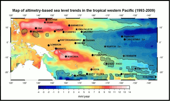
Figure 4 - Satellite altimtery-based sea level trend patterns in the tropical western Pacific over 1993-2009, on which are superimposed the 27 tide gauges used in the study. Stars correspond to the 7 tide gauges used in the global reconstruction. From Becker (2011)

But the downside of satellite observations is they have only been in operation for a short time. They do show a dramatic rise in sea level, in some areas in excess of 10mm per year (Honiara & Yap in figure 4), but the record only began in 1993, and 17 years (to 2009) is hardly long enough to tease out any decades-long natural variability that might exist. In other words, the rapid rate shown in the satellite data may not be indicative of the long-term rate of sea level rise in the region.

Global and regional sea level reconstruction

Becker (2011) set about reconstructing sea level over the period (1950-2009) by analysing the tide gauge, satellite altimetry, GPS data and use of an Ocean General Circulation Model. Combining a selection of 91 good quality tide gauge records (from 1950-2009) with gridded fields in the ocean circulation model they were able to unravel how sea level evolved in both time and space. To test how well their reconstruction matched observed sea level at a global scale, the authors removed a single tide gauge record from the reconstruction and compared the remaining reconstruction with that at the tide gauge site they removed. This exercise was repeated for each individual tide gauge. Finding good agreement, the authors then compared their reconstruction with the satellite altimetry over the period 1993-2009 in the western Pacific. See figure 5.

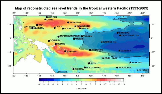
Figure 5 - Reconstructed sea level trend patterns in the tropical western Pacific from 1993-2009, on which are superimposed the 27 tide gauges used in the study. Stars correspond to the 7 tide gauges used in the global reconstruction. From Becker (2011).

As seen in figures 4 & 5, the reconstruction method does a good job of describing the actual change of sea level in the western Pacific, although the total amount of sea level rise in the reconstruction is smaller (at maximum & minimum) due to the statistical filtering method employed. See figure 1 for a comparison of the global reconstruction against the tide gauges for the western Pacific not used in the global reconstruction, and against the satellite altimetry.   

Tuvalu sea level rises with La Niña and falls with El Niño

As seen in the "Sea level fell in 2010" rebuttal, short-term global sea level can fluctuate due to the temporary exchange of water and snow between the land and sea, rising during El Niño when the land surface dries out, and falling with La Niña when the land surface recieves extra doses of rain and snow. In the western tropical Pacific, especially around Tuvalu, this trend is exactly the opposite, sea level there falls during El Niño and rises during La Niña. So what's going on?

This is largely due to the tilting of the thermocline in the tropical Pacific. See this animation for a great illustration of what this means. During La Niña strengthening of the easterly trade winds straddling the equator pushes warm water toward the western tropical Pacific. This warm water piles up in the western Pacific, which drives warmth down deep (the tilt of the thermocline), but it also causes the ocean to bulge upwards there due to the extra wind-driven water mass (see Timmerman [2010]Merrifield [2011] & Qiu & Chen [2011]). Both have the effect of raising sea levels, with the 'twin peaks' of sea level rise very obvious just north and south of the equator in figures 4 & 5 (the equator would be a horizontal line through Nauru).

During El Niño the trade winds weaken and the warm wind-driven water mass is no longer pushed toward Tuvalu and neighbouring islands. Instead the thermocline tilts back onto a more level plane, warm water begins to accumulate in the central Pacific, and accordingly sea level drops around Tuvalu.

The huge drop in sea level around Tuvalu, and nearby islands, shown in figure 1 around 1982-1983 is due to the strong El Niño during that time. Which goes to show not only how variable and sensitive to ENSO sea level in the western tropical Pacific is, but also how much variation there is even within the western Pacific itself. This ENSO/sea level relationship is shown in figure 6 below, however note that this graph accounts for the tropical western Pacific, not just Tuvalu.

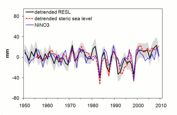
Figure 6 - Reconstructed sea level (RESL=black line) over the tropical western Pacific between 1950-2009 after the 1.8 mm per year trend has been removed (detrended). Gray areas represent RESL uncertainty. Red line=detrended steric (thermal expansion + salinity change) over the same period from ocean heat content data. Blue line= the NINO3 index, which is a measure of the sign (El Niño or La Niña) and strength of ENSO. See global map here for NINO3 region. From Becker (2011) 

Steric sea level is variation which results from changes in ocean heat content (thermal expansion), and changes in salinity (saltiness) which affects the density of seawater. Once the long-term trend has been removed (de-trended) from the reconstructed sea level and steric sea level, the relationship between sea level, the steric component and ENSO is plain to see in figure 6.     

GPS - accounting for vertical land movement

In many parts of the world the land surface is either very slowly rising or sinking, and this needs to be factored into reconstructions because, unlike the satellites measuring sea level, the tide gauges are firmly anchored to the sea floor. Becker (2011) sift through the GPS equipped western tropical Pacific tide gauge sites, ending up with 7 sites that are of sufficient quality for analysis. They make the assumption that the rate of subsidence (sinking) observed over the short time of GPS use, holds true back to 1950, and find that subsidence adds an additional 10% to the total sea level rise experienced at Tuvalu.

So to sum up:

  • In the tropical western Pacific the dominant short-term influence on sea level is the extremely large fluctuation due to the ENSO events El Niño (falling sea level at Tuvalu) and La Niña (rising sea level at Tuvalu).
  • Sea level at Tuvalu can vary by 20-30cms from the influence of ENSO. This is 40-60 times larger than the annual rate of sea level rise at Tuvalu.
  • This regional susceptibility to ENSO is because of the weakening (El Niño) or strengthening (La Niña) trade winds near the equator, which push warm water mass toward the tropical western Pacific.  
  • Becker (2011) uses a combination of tide gauge data, satellite observations, ocean modelling and GPS to assess sea level change around Tuvalu.
  • Removing all the factors which affect short-term sea level fluctuation, the study authors found long-term sea level at Tuvalu from 1950-2009 rose at the rate of 5.1 (±0.7) mm per year. This almost 3 times greater than the global average sea level over that time of 1.8 mm per year.
  • 10% of this 'total' sea level rise at Tuvalu is due to land subsidence

This is the advanced version of: Tuvalu sea level isn't rising

0 0

Printable Version  |  Link to this page

Comments

1  2  Next

Comments 1 to 50 out of 80:

  1. Perhaps the people of Tuvalu will follow suit.. The battle between some of the world's most powerful energy companies and an Alaska village that's losing ground to climate change heads to federal appeals court on Monday. Nine Kivalina residents, having survived the recent mega-storm that walloped western Alaska, will be at the Ninth U.S. Circuit Court of Appeals in San Francisco to watch their lawyers argue that ExxonMobil Corp., BP, ConocoPhillips and other corporate Goliaths owe the village at least $95 million in damages. A key Kivalina argument charges that the energy companies are engaged in a conspiracy to cover up the link between their emissions and the earth's warming temperatures. A similar argument proved pivotal decades ago in helping smokers prevail in court against tobacco giants. “Alaska village alleges climate change cover-up by Exxon, other energy companies” Alaska Dispatch, Nov 25, 2011 To access this article, click here.
    0 0
  2. Very clear and interesting. The abstract says : "Besides this sub-decadal ENSO signature, sea level of the studied region also shows low-frequency (multi decadal) variability which superimposes to, thus in some areas amplifies current global mean sea level rise due to ocean warming and land ice loss." Do we know the cause of this regional low-frequency variability? Have climate models any predictive skill about that in the Tuvalu area, for the coming decades?
    0 0
  3. When I started reading this article, I thought the "Tuvualuans have claimed detrimental sea level rise already" aspect would centre on salt infiltration of their ground water. The article was excellent, and Rob has done a good job describing the basics of sea level estimation. (I'm learning here, thanks.) But I wonder, what about measuring salinity in coastal aquifers. Obviously the modeling for the purposes of estimating sea level rise would be quite difficult. But in terms of detecting important impacts, wouldn't that be a helpful thing to monitor?
    0 0
  4. Steve, Indeed, Tuvalu has severe problems with salt water contamination of their groundwater. While there are some areas of Tuvalu that are three meters above sea level, the majority of the islands are less than 2 meters. When I visited Funafuti in 1989, there were large areas of some villages that flooded at king tides. I can only imagine how they are dealing with 10 cm more water (5.0 mm/yr times 20 years). Recent increases in wave heights cause substantial salt contamination of the aquafer by washing over the seaward sides of the island. If their stocks of ground water are contaminated they will have no water for their pigs and the coconut trees will stop producing. The recent La Nina related drought has caused stocks of rainwater (the primary drinking supply) to run low. Desalination is too expensive for the long run. How long will they be able to hold out? It is terrible. The Tuvaluans live a traditional lifestyle that they will not be able to replicate if they are forced to emigrate in masse. Tuvalu is a warning to the rest of us living in low lying areas. They do not have to be completely inundated to become uninhabitable. Miami will also run out of water (and storm drainage capacity) long before it is inundated.
    0 0
  5. I don't quite follow the point of this article. The 2000-2010 sea levels from Fig 1 look pretty flat for all the islands. There is certainly a rise from 1950-2000, so what is happening over the last 10 years?
    0 0
  6. @5 You can take any 10 year interval and see a leveling off a decline or even pink elephants. What in the "long-term rise" don't you get?? The same is true for temperatures droughts sea ice extent etc. False arguments and strawmen...
    0 0
  7. Another thing to consider is that the human mind generally thinks in linear fashion on human timescales, which tend to be day-to-day. That makes it exceedingly difficult to grasp non-linear, or exponential changes. Like projected SLR vs that which already has occurred.
    0 0
  8. No argument whether sea level is rising or not or where it is rising. You have the hard data which says it is and any reasonable person would have to admit that the rise will most likely accelerate over the coming years. However, we may be focusing on the wrong factor. It could be that sea level rise is the least of the worries of the coral atoll nations. http://mtkass.blogspot.com/2011/09/by-by-coral-atolls.html William
    0 0
  9. Hi Michael (@4) for all that interesting information. I was thinking in terms of detecting rising sea levels and understanding direct impacts in general. Sea level rises and falls with perhaps a decadal periodicity and AGW is adding an increasing trend on top of that. At the same time rain patterns change, there's irrigation, etc. That trend in aquifer salinity might not be easily detectable over short time scales. If saltwater contamination is an important prediction and outcome of AGW, then perhaps there should be a good baseline developed of the world's vulnerably coastal areas. I just briefly googled to see if there was a sort of global monitoring. I found this webpage for Tasmanian aquifer salinity. Looks to me as though good baselines probably aren't widespread.
    0 0
  10. skept.fr @ 2 - See Timmerman (2010), the full paper is linked to in the post. The projections indicate an El Nino-like trend (a weakening of the wind-driven water mass) in the 21st century, which will oppose sea level rise (SLR) in the Pacific Islands. Sadly it's nowhere near enough to counter the contributions to SLR by thermal expansion and melting land ice. Victull @ 5 - see SkS post: Hiding the incline in sea level William @ 8 - Thanks. See the SkS rebuttals on coral atolls. I hyper-linked to it in the post, but it's not conspicuous. Further reading on this related topic is in the SkS rebuttal on coral bleaching. It is incredibly simplistic to think that sand accumulation (indicated in your link) will alleviate problems. I'm sure you can see the flaws of such "skeptic logic." I don't even broach the issue of ENSO (La Nina/El Nino) effects on rainfall in the tropical western Pacific, nor the threat of storm surge intensification. Add ocean acidification into the mix, and I expect most rational people can connect the dots. Tuvalu is living on borrowed time.
    0 0
  11. DrTsk @6 Well DrTsk, I don't see any of the respondents disagreeing with my point about the last 10 years. You are talking to a lukewarnmer here - not a skeptic. That does not mesn that any query about a confusing picture need be dismissed as 'pink elephantry'. Rob Painting - I noted the 'hide the incline' post, however La Ninas don't run for 10 years. The 2010 La Nina was a big one but would not account for a 10 year trend.
    0 0
  12. Victull @ 5 and 11 Skeptical Science has addressed this type of thing over and over. If we choose the right short run of data, we can end up with some very odd trends indeed. The problem with this, in other words, is that all of us can identify ten year downward or level trends in the data even though the overall trend is upward: that is the nature of the kind of data we are considering. For example, just eyeballing the graph for Funafuti in Figure 1, I think I can see similar flat stretches or declines in the 1960 to 1970 and then 1980 to 1990 periods. On the other hand, the overall trend for Funafuti/Tuvalu and all the other locations in Figure 1 shows sea levels are rising for the 1950 to 2009 or 2010 period. Indeed, within that period, there are also decades where eyeballing the Funafuti graph can identify rapid rises (1950 to 1960, 1971 to 1981, and my favorite, since it overlaps the trend you've pointed out, 1993 to 2003). While La Nina events don't last for ten years, as you point out, it is readily apparent from the graph in Figure 1 and the associated graph in Figure 6 that La Nina and El Nino events correlate to upward and downward spikes in the data, and it is not fair to imply that there has only been one year of La Nina conditions in the last decade. NOAA identifies two significant La Nina events that predate the 2010-2011 La Nina event, which began in July of 2010. Both of these La Nina events took place after the impressive El Nino of 1997/98, which created spikes in many data sets around the world. One La Nina lasted from 1998 into 2001, and the other from 2007 through 2009. And now we have a third ongoing La Nina event. Here is the NOAA link: Multivariate ENSO Index with El Nino and La Nina events since 1950 Thus, the trend at Funafuti/Tuvalu from 2000 to 2010 is strongly influenced by the fact that it begins with a La Nina event which raises the local sea level, and ends with an El Nino which decreases it. [This paragraph inserted per request] Ultimately, it is important to note that because Funafuti/Tuvalu is in a relatively small area of the Pacific that has been exhibiting very large sea level increases, relative to the global average, over the 1950 to 2009 period, it makes sense (to me at least) that its graph contains these kinds of seemingly contradictory trends. An analogy that works for me is this: If I submerge my foot into a bucket of water or take it out, the water level in the bucket rises and falls quite appreciably, but if I insert my foot into a lake or take it out, the effects are much less dramatic. Tuvalu Island just happens to find itself in a part of the Pacific that for various reasons is behaving more like the bucket than the lake.
    0 0
    Moderator Response: [DB] Inserted missing text per request.
  13. Victul - "Rob Painting - I noted the 'hide the incline' post, however La Ninas don't run for 10 years. The 2010 La Nina was a big one but would not account for a 10 year trend." Perhaps large portions of the post were completely lost on you. Just to be clear: The long-term sea level trend at Tuvalu (over 1950-2009) is due to thermal expansion of the oceans, the addition of water volume to the global oceans by melting land ice, and the strengthening of easterly winds near the equator which pushes water mass into the tropical western Pacific. It is not related to ENSO - a large interannual fluctuation which hides the incline in sea level.
    0 0
  14. Rob Painting "The long-term sea level trend at Tuvalu (over 1950-2009) is due to thermal expansion of the oceans, the addition of water volume to the global oceans by melting land ice....." That could be said of any averaged point on planet Earth's oceans, and is an essential piece of evidence for global warming. Forgive me if I am a bit obtuse, but I don't see the point in focussing on Tuvalu as an example. Local variations on tiny dots in the Pacific would be irrelevant I would think. There is a danger that skeptics will take such emphasis on places like Tuvalu as alarmism by the global warming fraternity, which diminishes the general point about evidence of global sea level rise.
    0 0
  15. victull, presumably Tuvalu is focused on because it has one of the lowest elevations above sea level on the planet and thus would be amongst the first locations to be impacted by rising sea levels. Would it somehow make sense to study the impact of sea level rise on Mount Everest instead?
    0 0
  16. victull - "That could be said of any averaged point on planet Earth's oceans, and is an essential piece of evidence for global warming." No, again you haven't been paying attention. See figure 2 - note the west coast of Madagascar and the Northern Territory & western coast of far north Queensland in Australia - sea level has fallen there. "Forgive me if I am a bit obtuse, but I don't see the point in focussing on Tuvalu as an example." No worries, let me explain. Tuvalu is a low-lying coral atoll that will be one of the first nations in the world to be submerged by rising sea level. It therefore is a poster-child of sea level rise, and consequently is attacked by "skeptics" who claim Tuvalu is not being affected. See this nasty little article from Pat Michaels for instance. "Local variations on tiny dots in the Pacific would be irrelevant I would think" How very Pat Michaels of you. That you care little for the suffering of others is simply an indictment of skewed moral values. When do we start caring? When Florida starts to be submerged? Just to be clear, I live in New Zealand, the Pacific Island capital of the world. Many of my friends and former work colleagues are Pacific Islanders. They are important, and what happens to them matters. "There is a danger that skeptics will take such emphasis on places like Tuvalu as alarmism by the global warming fraternity" It is alarming. That is simply a fact. The fantasists and wishful thinkers will no doubt resort to blimp-pointing in an attempt to distract readers. It will be a futile exercise on their part.
    0 0
  17. Not too many countries have been wiped off the map before. I mean, there are a bunch that have been absorbed into others, but the land still exists and in many cases descendants of the original inhabitants are still there. Tuvalu will not persist, and the people/culture of Tuvalu will be extirpated. Countries that disrupt progress on treaties to limit carbon emissions are, in my naive opinion, waging undeclared war on Tuvalu and other low lying countries. Not only is it alarming -- it's disgusting.
    0 0
  18. "That you care little for the suffering of others is simply an indictment of skewed moral values" Rob, that is a pretty big leap up to the moral high ground which can be dangerously exposed. I have worked in the Pacific as well - Fiji, Tonga and Samoa so I have some familiarity with their culture and history. History might speak to you of many fairly recent migrations in the Pacific - one of the most significant being the Maori to your island home - New Zealand less than 1000 years ago. Why the Maori left their island homes to make the huge journey to New Zealand I could research for you - but I recall that overpopulation and depletion of resources (and perhaps even a bit of sea level rise in the medieval period) were likely drivers. Whatever - the Maori invasion of New Zealand was not good for the slow moving fauna, some of which rapidly became extinct. "Many of my friends and former work colleagues are Pacific Islanders. They are important, and what happens to them matters." And to me too. I am sure Australia and New Zealand will contribute mightily to resettling the Tuvuluans should they have to abandon their Islands. Perhaps Northern Territory & western coast of far north Queensland where sea level is dropping would be good places to recreate their tropical paradise. And by the way I have been paying attention: "That could be said of any ""averaged"" point on planet Earth's oceans, and is an essential piece of evidence for global warming." ""Averaged"" means that some points are up and some are down but on average the trend is up.
    0 0
  19. Perhaps Northern Territory & western coast of far north Queensland where sea level is dropping would be good places to recreate their tropical paradise.
    Given all the other current & forecast impacts of global warming, this strikes me as unlikely.
    0 0
  20. victull -- Would they be given sovereignty over 'far North Queensland'? Not sure what you're getting at with respect to Maori being bad for big slow animals, but surely that's not relevant to how we treat Pacific Islanders today? I mean, we're all descendents of self-interested migrants, but displacing people still isn't okay.
    0 0
  21. I have a few questions about this post: 1. I don't see any mention of what I understood about Tuvalu, namely, that it is a coral atoll and the coral is growing. I understood one of the main reasons Tuvalu was under threat was actually due to the fact the islands are "full of holes" to quote a Tuvaluan environmental official, due to sand being extracted for building. 2. Leading on from point 1, the population of the island has risen by a third since 1985. If the population had not exploded would the island be in trouble? Would it still be "full of holes", would its people be crammed onto lower lying area's previously uninhabited? Is this not a case of over-population rather than inundation?
    0 0
  22. Kellybrook @21: 1) Tuvalu consists of several coral atolls. However, people do not live on the coral, but on the islands that form when sand and reef debris form a layer over the top of the coral, killing it. The islands are more or less stable over time, with new reef debris replacing older sediment washed away by waves. However, with rising sea levels, more sediment is washed away with each storm, and the sediment that forms the island starts to be eroded. So, although the environment minister did lament that the Island was "full of holes", that was a consequence of rising sea levels, not a cause of land subsidence. 2) Below is a photo of the main island of Funafuti atoll (Tuvalu's capital): As you can see, the entire idea that the population has been pushed into low lying areas by over population is rather specious. True, areas 1 meter above sea level which were not previously occupied are not occupied, because the other areas 1 meter above sea level which where previously occupied are now full. Can you really think that is the main problem. More importantly, it is not the policy of the Tuvalu government to lower its tide level gauges by 1 mm per 1,000 head of population increase, nor is there a Tuvalu population adjustment in satellite altimetry. Both tide gauges and satellites show rising sea levels at Tuvalu, so without question this is an example of inundation.
    0 0
  23. kellybrook - Have you read the topic post? Tuvalu has been experiencing (Becker 2011) 5.1 (±0.7) mm sea level rise per year for the last 60 years, only 10% of which is due to subsidence (from, for example, being "full of holes"). Coral growth cannot keep up with that, and since the 'island' it self (as Tom Curtis points out) is sand on top of dead coral, it won't. That's over 1/4 meter rise in 60 years, on an island that is mostly less than 3 meters above sea level. Of course, if Tuvalu was uninhabited, this particular example would be less interesting. But it is inhabited, and does seem to be suffering some effects from sea level rise. The current and predicted sea level rise will wipe out most of the Pacific atoll islands over the next 100-150 years or so - and Tuvalu has (for better or worse) become an example of that.
    0 0
  24. @kellybrook #21 The post is about sea level rise around Tuvalu. It is probably the case that the things you mention tend to make the outcome of sea level rise worse, but they won't affect the rate of the rise. As you rightly say, Coral islands depend on living coral to grow; however both ocean acidification and bleaching mean that in the long term the ability of coral to grow will cease. From then onwards the islands will be vulnerable to erosion from the action of wind and waves until a point when it becomes uninhabitable. Clearly the rate of sea rise will influence the timing of this event.
    0 0
  25. KR- A point you need to consider is that the large sea level rise around Tuvalu is mainly due to the increased strength of the trade winds. The trade winds bank the water up in the western Pacific. The sea level rise is localised to that part of the pacific. Water finds it's own level without the trade wind that causes a gradient of level across the pacific. To extrapolate that the rate of sea level rise over the last 60 years will continue at that rate for the next 100 to 150 years means that the trade winds would also need to dramatically increase over the next 100 to 150 years. It's simple cause and effect. It's not difficult to see that there will be a limit to the strength of the trade winds. There will be some limit as to how much the trade winds can increase by.We won't have a 24 hr/day 365 days a year hurricane for a trade wind. You need to analyse the causes before extrapolating the effect.
    0 0
  26. Tealy "A point you need to consider is that the large sea level rise around Tuvalu is mainly due to the increased strength of the trade winds." But, what is your evidence that trade winds have increased on average in such a way to cause a long term change in sea-level? You need to cite some source before making statements like that.
    0 0
  27. Stephen - I came across one recent paper which suggests a strengthening of the easterly trade winds - which directly contradicts the Timmerman (2010) study which I cited. So future trends could see a further above-average sea level rise, or not.
    0 0
  28. Stephen, Firstly the article says:- "It just so happens that the western Pacific and Tuvalu in particular, are one such region where there is a large rise in sea level, much greater than the global average. See figure 3." Now you can't have one part of an ocean higher than anther part of that ocean without a continuous force to hold it there. Otherwise it just flows out until it is level. It is well known that winds cause the rise during la nina when the winds increase. Wind is the only effect that can be a long term cause of a localized sea level rise. Temperature or salinity differentials across an ocean are not sustainable due to eventual mixing. Referring to the diagrams above you can sea the sea level rise is localized and is also in the area that trade winds operate and effect. Just go back to basics and contemplate what could make the sea level locally higher, and also contemplate how high it can increase in relation to the ocean average before the force to outflow is just too great.
    0 0
  29. Anyone have further references as to the cause of the ocean near Tuvalu being higher than the ocean average?
    0 0
  30. Stephen Bains @26 Regarding you question as to trade winds causing the higher sea level at Tuvalu, I found the confirmation below in Wikipedia section on Tuvalu climate change:- "The 2011 report of the Pacific Climate Change Science Program published by the Australian Government,[3] describes a strong zonal (east‑to-west) sea-level slope along the equator, with sea level west of the International Date Line (180° longitude) being about a half metre higher than found in the eastern equatorial Pacific and South American coastal regions. The trade winds that push surface water westward create this zonal tilting of sea level on the equator." Therefore to have an even higher sea level at Tuvalu than the Pacific average means to have greater zonal tilting across the Pacific, which means to have stronger trade winds. ie you can't have an increased effect without having an increased cause. QED
    0 0
  31. Tealy, My question was, "What is your evidence that trade winds have increased on average in such a way to cause a long term change in sea-level? " You have simply provided evidence that local sea level near Tuvalu is higher relative to the rest of the Pacific basin because trade winds move surface water from east to west. No one questions that - it's established science. That does not explain the trend in sea-level near Tuvalu. Stating that trade-winds must be responsible for the trend because they are responsible for local elevation of sealevel in the tropical west Pacific is not good enough. The local elevation in sea-level has nothing to do, per se, with changes in sea-level over time. That would be confusing a temporal pattern with a spatial pattern. They need not have the same cause. You have posed a hypothesis - namely that increasing trade-are the sole cause of the increase in sea-level. The scientific approach would then be to test this hypothesis with data. A first step would be to show a corresponding increase in tradewinds with time. It would not be sufficient to make your case, because there is no reason to discount the role of observed changes in ocean water volume and you would not have established that the change in trade-winds was sufficient to cause the observed increase in sea-level. But it would be a necessary first step for you to be taken seriously.
    0 0
    Moderator Response: [Albatross] Bold tag fixed.
  32. For the record, there is evidence that global warming has caused a Hadley cell expansion and thus increased trade winds. However, as Stephen notes, that doesn't mean the sea level trend near Tuvalu is entirely, or even largely, due to the trade winds. That said, the root cause of any sea level rise due to thermal expansion, ice loss, or trade winds is the same... global warming.
    0 0
  33. CBD. I wouldn't be surprised if trade winds have increased, although I haven't seen the actual data saying so yet. I'm just trying to get Tealy to take a more scientific approach here in evaluating the influence of ocean volume on a local sea-level record, so there is something tangible to discuss.
    0 0
  34. CBD and Stephen Bains @32 & 33. Thermal expansion and ice loss affect all the ocean evenly, in other words these only increase the average sea level not the zonal tilting. For one part of an ocean to have a difference in level there must be a driving force. The difference in level is the effect, I am questioning, delving into, and asking what is the cause. Because to say the effect will continue to increase (ie that sea level rise around Tuvali will continue to rise at a greater rate than the ocean average), requires you to take a view that the cause will increase. I don't think you can take a view that a cause will continue to increase if you don't have a position on what you believe that cause to be. I would like to understand the cause. Reading through this article the basis for the extrapolation seems to be that the sea level around Tuvalu has been observed to increased at a greater rate than the ocean average for 50 years, and that trend somehow must continue for 100 more years. I don't see any evidence or basis put forward to support the extrapolation of zonal tilting, and there should be. What is the nexus? What causes zonal tilting? Why will the cause continue to increase for 100 years? To quote:- "The onus is on he who says it is so". There is evidence and basis that global warming will increase average sea levels, ie a warmer ocean will thermally expand (as long as it is above 6C otherwise it contracts with warming) etc. To say zonal tilting will increase due to global warming is insufficient. The nexus between more co2 and more zonal tilting is not my hypothesis to prove, and just because the two have increased does not prove a relationship. But I do want to understand so I can take a view as to whether the cause and therefore the effect will continue for 100 years.
    0 0
  35. Tealy - As I noted here, Tuvalu has gained attention because the islands are indeed suffering from sea level rises, and because they are populated. Hence that set of islands have become a "poster child" example of climate change affecting us. But regardless of trade winds, all atoll islands are going to suffer consequences from sea level rise - Tuvalu is just one of the first. It's simply a matter of time - as Becker 2011 notes, we're going to lose many of the western Pacific islands in the next 150 years, and other islands in other regions will follow depending on local sea level rise rates. And that's because the seas are rising, at rates that are only going to increase with further warming. If you disagree, I would suggest moving to the more relevant threads here or here.
    0 0
  36. @ Tealy I believe that part of the stumbling block impeding your understanding of SLR is implicit in the perception that the Earth is a sphere and that its mass is equally distributed. It is not a sphere precisely (equatorially bulging) nor is its mass equally distributed. It is thus more precisely described as a geoid. The reason this matters is that as ice sheets such as the Greenland Ice Sheet and those at the South Pole (the West Antarctic Ice Sheet plus the East Antarctic Ice Sheet) lose/offload mass (such as they are currently doing), the redistribution of mass that occurs will alter sea levels in a dynamic fashion: some localized areas may actually experience sea level lowering while yet other areas, such as Tuvalu, may experience a disproportionate amount of sea level rise.
    0 0
  37. Tealy - "Thermal expansion and ice loss affect all the ocean evenly" It would help to correct your lack of knowledge if you were to actually read the post you are commenting on. You missed the heading entitled "Sea level rise is not level", and all the accompanying text. Does figure 2 (reproduced below) look like an even sea level rise? No? Yes, we may see further anomalous sea level rise at Tuvalu and nearby western Pacific Islands, but we may not. Two contradictory scientific papers about the future trend there doesn't provide any illumination.
    0 0
  38. Tealy - it's not a personal attack it is a factual statement. You wrote that sea level rise was even, it isn't. And this was clearly spelled out in the article. Doesn't get much easier to comprehend than that. Sea level rise (SLR) is complex, it will be complicated by wind and ocean circulation changes, the distribution of icesheet melt (greater Greenland icesheet melt will give a different pattern of SLR than greater West Antarctic icesheet melt), land mass uplift in some regions. And that's just for starters. But this thread is about Tuvalu, the bigger picture will have to wait for another post. Also, I've mentioned numerous times on this thread that sea level projections for the western tropical Pacific are contradictory. That's just a reflection of how split the climate models are on future warming trends in the Pacific, i.e will the Pacific Ocean background state of the future resemble a La Nina, El Nino pattern, or stay much the same?
    0 0
  39. Rob @39 Ok Rob, please read my questions again. I will help you with you lack of comprehension. I am not asking about average sea level rise which is caused be ice melt etc, I am asking about zonal tilting.
    0 0
  40. Does anyone have references to articles as to the causes of zonal tilting? Anyone studies up on such articles? As zonal tilting is the crux of this main article, I would like a better understanding of it's causes, noting the above article is observational rather than analytical.
    0 0
  41. 'Anyone studies up on such articles?' Yes, no less than 3 such peer-reviewed scientific papers are hyper-linked in the article above. Timmerman (2010), Merrifield (2011) and Qiu & Chen (2011). As for zonal tilting, I think you may be confused with the tilting of the thermocline that occurs during El Nino/La Nina, a periodic event. Long-lived changing wind and ocean circulations are responsible for the anomalous sea level rise at Tuvalu. And your comment about observational versus analytical is nonsensical. It appears as if you are scrambling around to find something to nitpick at so that you can dismiss the findings of Becker (2011). What you choose to believe is up to you, but the facts are the facts, and as is often the case with global warming, they are extremely inconvenient. As I will point out in future posts, the coral atolls of the Pacific Islands have other threats looming fast on the horizon - mass coral bleaching and ocean acidification. Sadly, atoll islanders are living on borrowed time.
    0 0
  42. RP @41 No I am not confusing zonal tilting with a thermocline, and you could work on your tone and choice of words. A thermocline is a temperature change in a body of water that changes with depth. Ref Wikipedia http://en.wikipedia.org/wiki/Thermocline. Zonal Tilting is the difference in height across an ocean. Again I will quote a lay resource, Wikipedia:- "... by the Australian Government,describes a strong zonal (east‑to-west) sea-level slope along the equator...The trade winds that push surface water westward create this ZONAL TILTING of sea level on the equator" While a thermocline can contribute to zonal tilting, these are not the same thing. My reference to an "observational report" vs an "analytical report" was on purpose. Such parlance is common among analytical science backgrounds. It is a strange term, say look at this meteorological website where the reporting of such things as humidity and barometric pressure are called observations, when in reality how can you observe barometric pressure? http://www.bom.gov.au/products/IDN60901/IDN60901.94767.shtml An analytical report seeks to analyse and explain observations. Referring to Timmerman (2010) there are some answers thank you. As I suspected there is major uncertainty as to predicting the anomolous rises in sea level above the mean sea level rises as recorded at places like Tuvalu. "Recent assessments of future sea-level rise have focused on global mean sea level rise and the contributions due to thermal expansion, glacier melting and the disintegration of ice-sheets (e.g. Church and White (2006); Rahmstorf (2007); Bindoff and et al. (2007)). However, there is still a major uncertainty with respect to the regional characteristics of projected future sea-level rise, as stated both in the third and 4th assessment reports of Working Group I of the Intergovernmental Panel on Climate Change (e.g. Hesselbjerg Christensen and et al. (2007)). Identifying the causes of this uncertainty and developing a better understanding of the drivers of future regional sea-level change, in comparison to the global mean estimates, would be very beneficial for policy-makers in many different countries and Island Nations." The report does discuss trade winds and deepening thermoclines as increasing these "regional sea level rises", which brings me back to my original point and that the regional increase does have limits. For example a thermocline can only deepen until it hits the seabed. And trade winds can only increase so far. Therefore it is not valid to extrapolate the zonal tilting component from sea level rise ad infinitum, as Timmerman has refrained from doing. Would appear there is no validation to use a figure as high as 5.1mm/yr for the next 100 years. Does anyone know a source for a P50 of the sea level rise around Tuvalu ove the next 100 years.
    0 0
    Response:

    [DB] "you could work on your tone and choice of words"

    Please refrain from picking at nits when from your first comment you have continually downplayed the unknown (by you) continuum of experience held by the various participants here relative to your own when it is patently obvious that you have not fully comprehended the OP of the post you are commenting so authoritatively on. Or, when others have tried to help you achieve the understanding you are looking for, you incorrectly perceive their helpful comments as a personal attack.

    Phrases like "glass houses" and "pots calling kettles" or worse come to mind.  If you want objective, science-based dialogue free from invective and snark, model it for others to emulate.

  43. "Therefore it is not valid to extrapolate the zonal tilting component from sea level rise ad infinitum" True, but that is a strawman argument of your own making. As I have stated repeatedly on this thread, projected future trends are contradictory. You don't appear to be comprehending this rather obvious fact. "Would appear there is no validation to use a figure as high as 5.1mm/yr for the next 100 years. Does anyone know a source for a P50 of the sea level rise around Tuvalu ove the next 100 years." Well no one here, apart from you it seems, expects sea level rise at Tuvalu to only be influenced by the change in wind and ocean circulations. It's sinking too remember? And I don't know what you expect to keep all that ice in the West Antarctic ice sheet from melting, and to a lesser degree, the Greenland ice sheet. That melted ice will contribute significantly to sea level rise, including at Tuvalu. They'll be extraordinarily lucky to just see 5.1mm of sea level rise over the next 100 years. The height of the Eemian interglacial (around 125,000 years ago) saw ice sheets on Greenland and Antarctica not too dissimilar in size than today. Yet under the gradual orbital forcing of that period the ice sheets collapsed. This was principally the West Antarctic, even though the solar insolation forcing was focused on the northern hemisphere. Multi-meter sea level rises occurred over century-long timescales, i.e at least four times the current rate of sea level rise at Tuvalu. If that happened from the slight orbital forcing nudge back in the Eemian what prospects from the almighty shove we humans have given the climate? We already have roughly 25 metres of sea level rise to come over the next thousand years or more, just from the CO2 we have already put into the atmosphere. And, of course, given current rates of fossil fuel burning all the coral at Tuvalu will be dead in a 100 years time, from a combination of mass bleaching and ocean acidification. There's clearly no point trying to minimize this, the science is very clear - it's bad, very bad.
    0 0
  44. Tealy, Where are you coming up with your sea level rise estimates? The current science based estimates range from 75 cm to 2 meters by 2100. That is a minimum of 80 mm per year over that time frame. A central estimate would be 160 mm/yr, more than three times the current rate. It is absurd for you to claim that sea level rise will decrease when it is expected to dramatically increase. Please provide a reference for your extraordinary claims of a change in sea level projections. Perhaps if you read some of the posts on SkS you will learn about expected sea level rise. I found about 20 posts using the search function in the upper left corner.
    0 0
  45. In my post above I misplaced the decimal. It should read minimum of 8.0 mm/yr and central estimate of 16.0 mm/yr for the entire globe. 16.0 mm/yr is three times the current rate (at Tuvalu). The expected rate of sea level increase is not linear so averaging the rate as mm/yr over the entire time period is not very meaningful. It does indicate that Tuvalu is in for a world of hurt when the sea really starts to rise.
    0 0
  46. Ice melt is the lesser component of sea level rise and sea based ice contributes zero to sea level rise (Archmedes) only land based ice does. Thermal expansion is the main component of sea level rise but only if the water is above 4c and for practical purposes above about 6C. The focus on ice melting is merely something the general population can understand.
    0 0
  47. Tealy -"Ice melt is the lesser component of sea level rise And the recent paper supporting this would be?
    0 0
  48. RP @47 Not much of the world has land based ice, and that ice melt has to spread out and rise all of the oceans. Its a big ass ocean, so its logical to question the impact of ice melting. The average ocean depth is 4 km, and its the thermal expansion of this 4 km high column that causes the top of the column, sea level, to rise upwards. Eg 1% expansion of 4 km equals 40 metres, but some does flow outwards onto land. Many years since I've seen papers on impact of ice melt vs thermal x, so ill have to google one. Try this from Science Org http://www.science.org.au/nova/082/082key.htm Quote:- "Thermal expansion While thermal expansion is a less obvious process than melting ice (mainly because you can't see it happening) the IPCC projects that thermal expansion will be the main component of expected sea-level rises over the 21st century.".. People say it's ice melting rise because as it's something they can see and touch, but it's a misnomer that should not be propagated. It's wrong, its patronising, and it destroys credibility to change the facts in the belief people wouldn't have understood.
    0 0
  49. Tealy, When you make statements that are completely wrong no-one will listen to what you say. Please read some of the extensive background at Skeptical Science about sea level rise before you spout more nonsense. I used the search function with "sea level rise" and got about 30 hits. Please read some of them like how much will sea level rise. Until you have some background knowledge it is difficult to discuss the subject with you. Possible sea level rise from thermal expansion starts immediately (not at 4C, the sea is salt water, not fresh). Thermal rise is estimated at about 1 meter total and immediately flows over the land. Sea level rise from melting ice can be as much as 70 meters. If you do not know the basics you cannot inform anyone else.
    0 0
  50. Michael @44 Its good to discuss and learn, thats the point of forums. There are two types of people; those capable of independent thought, and those that follow what they are told to think and do not question and analyze. We should all strive to be the former through avenues such as forums. I am not claiming sea level will decrease, I believe it will increase. To be clear:- I agree average sea level rise has been about 1.8mm/yr over the last 100 years. I believe Tuvalu has been sinking about 0.5mm/ yr for the last about 50 years. I believe there has been a zonal tilting increase (regional increase if you want) of about 2.6mm/yr over the last 50 years. What I can't find is agreed and validated causes for the zonal tilting or a validated projection for the increase in zonal tiliting until 2100. I have searched references as you suggested but I have missed it or it's not there.  Timmerman actually stated that there is major uncertainty as to the future regional characteristics of sea level rise.  IPCC AR4 (2007) report predicts that sea level rise will be 0.6 – 1.9 feet by the year 2100 You state a central estimate of 16mm/yr for Tuvalu. This would be 4.6 ft over the next 88 years. Meaning that zonal tilting would increase by 2.7 ft to 4.0 ft. I cannot find any science that supports that such a large differential in level across an ocean can exist. I am talking physical sciences. If you have a specific source as to large zonal tilting please let me know.  My specific point is, that we don't know what caused the zonal tilting, so on what reasonable basis can we expect it will continue to increase? As RP stated @43 the future trends for the regional variations are contradictory In fact if you refer to http://www.wamis.org/agm/meetings/rsama08/S304-Shum_Global_Sea_Level_Rise.pdf It shows that the sea level rise in the Tuvalu region was about 1.6 to 1.8 mm/yr for 1900 to 2003. So over that century Tuvalu experienced average sea level rise. As it received higher than average in the second half of the century, then it must have received lower than average for the first half of the century to be average over the whole century. So what caused the lower than average sea level rise in the first half of the century? Is it a cycle? The point is that zonal tilting is poorly understood yet it is the basis for stating that Tuvalu will have high than ocean average sea level rises until 2100. Statements that Tuvalu will experience massive sea level rise over the next 100 years will only drive away investment they critically need. But there is no solid science that Tuvalu will experience higher than average sea level rise. If time proves that Tuvali only experiences average sea level rise, then this will have been a travesty.
    0 0
    Response:

    [DB] As Michael Sweet has already pointed out to you, it is better to spend time reading up on SLR before speaking so authoritatively about it.  Use the Search function to find many articles here at SkS using much more recent estimates of SLR than contained in the IPCC AR4.

    Projected SLR increases are based on land-based ice sheet losses, primarily from the Greenland Ice Sheet (GIS) and the West Antarctic Ice Sheet (WAIS).  These losses are increasing in greater-than-linear fashion.  Indeed, recent research shows decadal-scale doubling of losses can be expected.

    Thus, solid scientific research in the peer-reviewed literature documents massive sea level rises can be expected by 2100 relative to past rates of SLR.  The travesty is denying this documented research without actually reading it first.

1  2  Next

You need to be logged in to post a comment. Login via the left margin or if you're new, register here.


The Consensus Project Website

THE ESCALATOR

(free to republish)


© Copyright 2024 John Cook
Home | Translations | About Us | Privacy | Contact Us