


 Arguments


Is Greenland gaining or losing ice?
What the science says...
| Select a level... |
 Basic
Basic
|
 Intermediate
| |||
|
While the Greenland interior is in mass balance, the coastlines are losing ice. Overall Greenland is losing ice mass at an accelerating rate. From 2002 to 2009, the rate of ice mass loss doubled. |
|||||
Climate Myth...
Greenland is gaining ice
“[E]ven if it were true that Greenland’s ice had been melting at ‘new record’ rates, after seven and a half years of global cooling global warming cannot be the cause. The true position in Greenland is to be found in Johannessen et al. (2005), where satellite altimetry established that the mean thickness of the entire Greenland ice sheet had increased at 2 inches per year – a total of almost 2 feet – in the 11 years 1993-2003.” (Christopher Monckton)
Global warming affects Greenland in two ways. Warming temperatures cause the ice sheets to thin and lose ice mass around the edges. On the other hand, warmer temperatures also cause more snow to fall in Greenland's interior. Which has the greater effect? Is Greenland losing or gaining ice?
Over the years, a variety of techniques have been employed to measure Greenland's mass balance. Snow pits are dug to measure snowfall. Stations are set up to measure incoming and reflected sunlight. Aircraft use laser altimetry to measure changes in surface elevation. Melt areas are determined by satellites reflecting microwaves off the surface. Satellite radar interferometry measure the horizontal movements of Greenland's glaciers. In 2003, NASA launched the Ice, Cloud, and Land Elevation Satellite (ICESat), using laser altimetry to more accurately measure changes in the Earth’s surface elevation.
All this data has been pieced together to form a continuous picture of Greenland's mass balance from 1958 to 2007 (Rignot et al. 2008). There is robust agreement between the various independent measurements and a clear long term trend is apparent. In the 1960s, the ice sheet was losing 100 gigatonnes of ice per year. In the 1970s-1980s, the rate of ice loss slowed to near mass balance. In 1996, the rate of ice mass loss had increased to 97 gigatonnes per year. In 2007, the ice mass loss increased rapidly to 267 gigatonnes per year. To put this into perspective, a gigatonne is one billion metric tonnes, the mass of a cube of water that is 1 kilometre wide, tall, and deep.
So we see a long term trend of accelerating ice mass loss since the 1970s. This is confirmed by the Gravity Recovery and Climate Experiment (GRACE) satellite, measuring shifts in Earth’s gravity field. The GRACE data offers a complete picture of the entire ice sheet, allowing comparisons of mass changes in coastal regions (eg - elevations below 2000 metres) with the Greenland interior (above 2000 metres). Over the period 2003 to 2008, the coastal regions were observed to be losing ice mass while the interior was in approximate mass balance. The overall result is that the Greenland ice sheet is losing ice mass (Wouters et al. 2008).
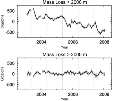
Figure 1. Mass loss from the Greenland ice sheet for coastal regions below 2000 metres (top) and interior regions above 2000 metres (bottom). (Wouters et al. 2008)
The latest GRACE data reveals more about the long term trend. Figure 2 shows the ice mass changes in Greenland from April 2002 to February 2010 (originally published in Velicogna (2009) with more recent data from John Wahr). The black line/crosses show monthly values of ice mass. The orange line is the best fitting quadratic trend. The best fitting trend finds that Greenland ice loss is accelerating at a rate of 30 Gigatonnes/yr2. Greenland's mass loss doubled over the 8 year period.
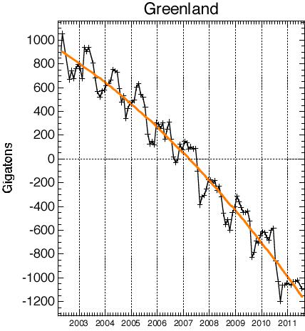
Figure 1: Greenland ice mass anomaly - deviation from the average ice mass over the 2002 to 2010 period. Black line shows monthly values. Orange line shows long-term trend (John Wahr).
The long term trend since the 1970s is accelerating ice mass loss. This is confirmed by gravity satellite measurements over the past 9 years which find that the rate of ice mass loss has doubled over the last 9 years. Just as with Antarctica, Greenland's ice sheet contribution to rising sea levels is continuously and rapidly growing.
Intermediate rebuttal written by John Cook
Update July 2015:
Here is a related lecture-video from Denial101x - Making Sense of Climate Science Denial
Additional videos from the MOOC
Expert interview with Jonathan Bamber
Expert interview with Eric Rignot
Expert interview with Isabella Velicogna
Last updated on 6 July 2015 by pattimer. View Archives


[DB] "the Times Atlas cartographers got it totally wrong and can't admit it."
As one who spent many years as a professional cartographer, this statement (and your closing paragraph) are spot-on.
The mind boggles.
Last updated Nov 2011? I think this needs an update! Come on John, I'm sure you have nothing but time on your hands. :)
I wonder if a Walker type cell could develop between the ever warming Arctic Ocean and the Greenland Ice sheet. Rising warm air contacts the ice, cools and flows down the ice sheet warming by compression and giving its heat to the ice. Warm foen winds cause extreme melting when in contact with ice.
... interesting: I wish I knew the answer to your question!
Recommended supplemental reading:
New Greenland maps show more glaciers at risk by Carol Rasmussen, NASA's Global Climate Change, Nov 1, 2017
I've noticed new claims that Greenland is gaining ice. It seems Steven Goddard (Tony Heller) a graph by Danish researchers on a web page 'Current Surface Mass Budget of the Greenland Ice Sheet'. It was picked up in Goddard's "Deplorable Climate Science Blog" as "Massive Growth In Arctic Ice Since Last Year" and that has been amplified by contrarians who in this case prefer to believe models to satellite data (eg "Grace data update reveals NASA Greenland mass-loss fraud").
The confusion is simply resolved by reading the explanatory text.
Ceddars @16: Based on your summary, Heller seems to be conflating Arctic sea ice with the Greenland ice sheets. Is that the case? (I personally do not wish visit Heller's blog to find out.)
John,
The graph Ceddars linked to (apparently from Goddard's site) is a graph of yearly snowfall and surface snow melt on Greenland.
The paragraph Ceddars quoted correctly describes that more snow falls each year than melts (I think in 2012 more snow melted but most years more snow falls than melts). The graph does not include melting of glaciers or calving of icebergs so it is not a complete record of Greenland ice.
The GRACE gravity data show that more ice melts each year than falls as snow. GRACE measures surface melt and ocean melt.
Sorry, there was an important word missing in my post 16 - Goddard Heller 'misrepresented' the graph, but I was going to be charitable and write 'misinterpreted'. However, it's possible he personally understands the difference between surface and total mass balance but has avoided explaining it.
The minimal text in 'Massive Growth In Arctic Ice Since Last Year' (Nov 2017) concerns both sea ice and the Greenland Ice sheet - it makes no claim the two things are related but leaves readers to draw a conclusion. Previous uses of the DMI graph includes 'Greenland Ice Growth Ahead Of Last Year’s Record Pace' (Oct 2017) which seems oddly careful to specify that DMI does show surface mass balance given that it goes on to talk of 'criminals in the press and academia'; 'Record Greenland Ice Growth Continues' (Sep 2017); 'Scientists Discover That Their Imaginary Greenland Meltdown Is Not Having Any Effect' (June 2016); and over at NTZ 'Danish Meteorological Institute Moves To Obscure Recent Record Greenland Ice Growth' (Gosselin, April 2017) mentions 'massive ice growth' without any sign of being aware of calving loss.
On 24 April Goddard Heller tweeted 'Contrary to the lies of government scientists, Greenland has gained a record 600 billion tons of ice this winter.' I pointed out the possible source of confusion, and Goddard blocked me shortly thereafter.
[JH] Please use Heller's real name.
To clarify the situation regardingGoddard/Heller's use of DMI graphics.
He shows the DMI Accumulative Surface Mass Balance graph (the lower one of the above) in two of his November posts (so far). In the first of these posts (Nov 1) he says "Greenland ice growth is close to last autumn’s record high." (His screen-shot of the graphic does not past Nov 1.) This strongly suggests Heller/Goddard doesn't understand AccSMB.
This was preceeded by a graphic showing the differences between two NOAA SIE graphics aserting "Arctic sea ice extent is up 16% from last year."
This is perhaps no surprise. 2016 was jaw-droppingly un-icy through the Autumn, setting new records for low ice. Using JAXA daily data, 2017 was 14% above 2016 on 30 Oct (& almost 16% up on 2016 on 18 Oct. Yet a percentage is a little silly as a measure - SIE grows over 50% through the month of October). And of course, the whole comment is silly as 2017 remains a very un-icy year, as shown in this JAXA SIE anomaly graphic (usually 2 clicks to 'download your attachment'). 2017 SIE is at present in 3rd place behind 2012 & 2016.
In a second post (Nov 9) Goddard/Heller again posts the DMI Acc SMB graph saying "The last two years have seen near record ice gain in Greenland." Additionally, to back his primary assertion that there has been a massive expansion of thick ice over the last decade, he blinks two DMI graphs (below) but with the thinner sub 1.5m blue and purple sea ice whited out. While the areas of thick ice may be greater 2007-17 as Heller/Goddard says, PIOMAS shows a healthy drop in total sea ice volume between Oct 2007 and Oct 2017 of 990 cu km.
I understand that Greenland is not gaining ice now after the 2000s and it decreases over 300 billions of tons of ice every year. Because of the world temperature increases can cause too much ice loss so it cannot change all of the water from ice to precipitate all of it at the interior. But why Greenland is highly sensitive to warmer temperatures?
Partly because, due to its latitude, it gets a lot of summer insolation from the sun (much more so than does the Antarctic Ice Sheet), and partly due to its proximity to warming ocean currents. Poleward convective energy transportation systems do the rest (helping to raise the ablation line higher up the ice sheet, driving further mass balance changes).
Contrasting temperature trends across the ice-free part of Greenland (25 January 2018)
https://www.nature.com/articles/s41598-018-19992-w
"less than 36% of the ice-free Greenland has experienced a significant trend and, if any, a cooling is observed during the last 15 years (<0.15 °C change per year)."
"Warming trends observed from 1986–2016 across the ice-free Greenland is mainly related to warming in the 1990’s. The most recent and detailed trends based on MODIS (2001–2015) shows contrasting trends across Greenland, and if any general trend it is mostly a cooling. The MODIS dataset provides a unique detailed picture of spatiotemporally distributed changes during the last 15 years."
So why is there less ice if it's overall cooling?
https://www.nationalgeographic.com/environment/2018/09/news-greenland-ice-sheet-melting-arctic-algae/
Is it because of algae and lowwer albedo? Any impact of delayed mechanisms, sea currents maybe?
The ice-free part of greenland is only the southern/south-western edge which happens to be on edge of the North Atlantic "cold-blob" (see here for maps and further discussion of cold-blob). On the other hand, the ice-covered part of Greenland continues to warm and shed ice. Your reference was about the observations on the ice-free part.
Sarmata @23,
Your question is a little silly as there cannot be less ice if the analysis is conducted across "ice-free Greenland" and the annual average trend in Land Surface Temperature (LST) presented by Westergaard-Nielsen, et al (2018) is not "overall cooling" but overall warming through the period 1986-2016. The latter half of the period (2001-15) shows neither warming nor cooling at an annual level but does show a warming trend through summer (July) and a cooling trend through autumn (Sept-Dec), a situation which could still result in increased ice melt (if there were any ice to melt). The paper specifically proposes a link between the rate of ice-free Greenland LST warming and the Greenland Blocking Index (rather than the "cold blob" suggested by scaddenp @24).