Climate Science Glossary

Term Lookup

Enter a term in the search box to find its definition.

Settings

Use the controls in the far right panel to increase or decrease the number of terms automatically displayed (or to completely turn that feature off).

Term Lookup

Settings


All IPCC definitions taken from Climate Change 2007: The Physical Science Basis. Working Group I Contribution to the Fourth Assessment Report of the Intergovernmental Panel on Climate Change, Annex I, Glossary, pp. 941-954. Cambridge University Press.

Home Arguments Software Resources Comments The Consensus Project Translations About Support

Twitter Facebook YouTube Mastodon MeWe

RSS Posts RSS Comments Email Subscribe


Climate's changed before
It's the sun
It's not bad
There is no consensus
It's cooling
Models are unreliable
Temp record is unreliable
Animals and plants can adapt
It hasn't warmed since 1998
Antarctica is gaining ice
View All Arguments...


Username
Password
New? Register here
Forgot your password?

Latest Posts

Archives

Working out future sea level rise from the past

Posted on 9 February 2010 by John Cook

Predicting future sea level rise is tough. A growing contributor to sea level rise is ice sheets that break off into the ocean. However, ice sheet dynamics are non-linear and difficult to predict. The IPCC 4th Assessment Report essentially ignores ice sheet dynamics, predicting sea level rise of 18 to 59 cm by 2100. More recent research accounting for accelerating ice sheets predict sea level rise of 75 cm to 2 metres by 2100 (Vermeer 2009, Pfeffer 2008). Even these latest predictions admit they may not fully predict the non-linear aspect of ice sheet dynamics. However, there is another way to determine future sea level rise that neatly sidesteps the complexities of non-linear dynamics. Look at how sea level has responded to temperature change in the past.

The last interglacial around 125,000 years ago is a period of special interest. The Earth's orbital eccentricity was more than twice the current value, meaning the orbit was more elliptical. This caused warmer summer temperatures than current conditions. Sea surface temperatures at the equator were about 2°C warmer than pre-industrial levels. Ice cores from Greenland and Antarctica find polar temperatures were about 3 to 5°C warmer than today.

Thus the last interglacial provides an insight into where our climate is currently headed over the next century and beyond. A global compilation of sea level indicators from reefs, corals and sediments were used to estimate global sea level during this period. The result was that it's very likely (95% probability) that sea levels were at least 6.6 metres higher than today. It's likely (67% probability) that sea levels exceeded 8 metres (Kopp 2009).
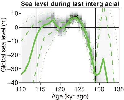

Figure 1: Probability density plot of global sea level during the last interglacial. Heavy lines mark median projections, dashed lines the 16th and 84th percentiles, and dotted lines the 2.5th and 97.5th percentiles (Kopp 2009). Global sea level of 0 represents current sea level.

Independent analyses of the last interglacial paint a similar picture. A number of studies have found sea levels during the last interglacial much higher than modern levels, all concluding that ice sheets are very sensitive to temperature change (Blanchon 2009, Overpeck 2006, Rohling 2007). It's important to note that this doesn't mean sea levels will rise 6.6 metres by 2100. It takes time for the ice sheets to respond to warming and there is still much uncertainty over exactly how quickly sea levels will reach such levels.

Nevertheless, the bottom line is the global warming expected over the next century will take us to temperatures that in the past raised sea levels over 6 metres higher than current levels. This is a sobering fact for the millions of people concentrated on coastlines.

0 0

Printable Version  |  Link to this page

Comments

1  2  Next

Comments 1 to 50 out of 91:

  1. Orbital eccentricity variations has no effect on annual average "solar radiative forcing". It is only the seasonal distribution of incoming radiation which changes. Depending on the phase, it can make northern summers warmer than average and winters colder. Or the other way around. Carbon dioxide has no such seasonal effect, or, if anything, it makes seasons more even. The two "forcings" are not comparable.
    0 0
  2. There are two points I want to make. First of all, ice sheets such as those that have broken off from Antarctica have a nil effect on the sea levels when they melt because the weight of the ice has already displace the water it is floating on. As for the constant moving of ice such as can be observed in Alaska, the motion is a regular part of the glacial activity and takes place when the mass of the glacier in its middle, increases, forcing the glacier to spread out towards its extremities. Secondly when the orbit of a body becomes more elliptical, then there are sections of the orbit that are further from the sun than they would be if the orbit was circular and hence would be further from the son when positioned at the long elliptical axis.
    0 0
  3. Geo Guy, you've got your terminology slightly off. ice SHEET - Ice resting on land. ice SHELF - Ice floating on water. The breakup of floating ice shelves does not raise sea levels. The collapse of ice sheets off of land and into the oceans does. Berenyi, since your comment seems to have nothing to do with the article above I'll assume you are still objecting to John's statement in the prior article that climate sensitivity applies to both internal and external forcings. In your response here you argue that forcings are different. Congratulations, that is true. However, an orbital eccentricity which causes arctic sea ice to melt is going to have exactly the same climate sensitivity as warm ocean currents melting that arctic sea ice... or CO2 induced warming. The feedback effect, melting arctic sea ice decreasing the planet's albedo, has the same sensitivity regardless of what forcing is driving it.
    0 0
  4. Further to Geo Guy and CBDunkerson, here's an interesting snippet from the just-past AGU meeting discussing some underlying details (pun, sorry!). Look for "Antarctic Glacier Off Its Leash": Pine Island Glacier Geo Guy, timing of the eccentricity versus seasons counts for much.
    0 0
  5. By my very rough reading of the graph we have: Maximum rate of rise at the end of glaciation = 10mm/yr (40m in 4000 years) Rate this century predicted by AR4 = 1.8 - 5.9mm/yr Rate this century including best understanding of ice sheet dynamics = 7.5 - 20mm/yr Current rate (satellite data) = 3mm/yr Which prompts a couple of questions: 1) When could we reasonably expect to see a statistically significant rise in rate of sea level measurements ? 2) It's really the rate of warming that matters, not it's magnitude (even 6 degrees over a few million years wouldn't matter much). What is the maximum rate of rise we can cope with without huge disruption ?
    0 0
  6. "To minimize the influence of any bias in individual points, we infer MIS-5e sea-level fluctuations after smoothing the data with a moving 750 yr gaussian filter" Does not this mean that short rapid increases in sea level rise are averaged out. In all the papers I could access I noted a significant degree of uncertainty on timing. We need to be overestimating the sea level rise not underestimating. If we overestimate it means we will be ready early.
    0 0
  7. Thanks for taking this topic up. To steal a quote "uncertainty is not your friend"
    0 0
  8. The problem with sea level rise is that we do not have enough resolution in the paleo data to assess rapid changes. So we are forced to consider the average behaviour, which is already bad enough. But it might be worse. Although we can not directly compare current climate with deglaciacion, ice sheets collapse proved to be able to produce the so called melt water pulses with sea level rise of the order of several meters/century. Current acceleration of large ice sheets in West Antarctica and Greenland sound much like the alarm bell.
    0 0
  9. VeryTallGuy at 07:46 AM on 9 February, 2010 Short questions leading to a myriad of of risk and unknowns! Assuming that ocean heating remains reasonably constant, acceleration of rise is going to come down mostly to how glaciers and ice sheets behave. People are beavering away at that problem which of course is a bundle of contextual complexity. A crisp or even acceptably fuzzy answer just does not seem available right now. As to disruption, IMHO that depends a lot on how the next few decades of population growth proceed as well as how we choose to continue developing or not developing areas at risk from sea level increase. I guess "huge disruption" especially depends a lot on perspective, that is to say what's the angle between your line of sight where you live and the surface of the ocean. If you're seeing close to zero degrees there's some cause for concern. Take New Orleans as an edge case representing the worst case and there you have an example of a place where not even the slightest acceleration is going to be tolerable. NOLA is barely keeping its head above water as it stands, or that is to say the damage inflicted on it in the present context is barely supportable. Can the USACE dig any faster? Evidence says "no", not without a big shift in resources. If not and we see New Orleans gradually reduced to a shallow spot over the space of 50 years I suppose that's a big disruption, and it's reasonable to say it'll happen even without an acceleration. Move on to Holland. How much faster can -they- dig? What about Bangladesh? Rosy interpretations excepted, not a lot of dynamic range available there even without an acceleration, yet population growth keeps the pressure on at the seashore. It just does not seem like much acceleration is going to be tolerable.
    0 0
  10. CBDunkerson at 04:41 AM on 9 February, 2010: "The feedback effect, melting arctic sea ice decreasing the planet's albedo, has the same sensitivity regardless of what forcing is driving it" Not quite so. It depends on where this ice sheet is located and how large it is. In glacial times ice in the northern hemisphere came down to midlatitudes, see ice grooves in Central Park, NYC. The lack of ice there makes a huge impact on global albedo. The arctic, on the other hand, is in darkness for half a year anyway and mostly covered by low level clouds for the rest. Not much trend in albedo is observed. Part of current sea level rise is due to postglacial rebound, the reconfiguration of continental crust, ocean basins and mantle below. It would go on irrespective of any warming, at a constant rate (on millenial scale). As for thermal expansion of seawater, it can be measurable if it occurs above the thermocline. Below it the water is so cold, that the thermal expansion coefficient is negligible. However, OHC (Ocean Heat Contents) is not increasing in the upper 700 meter recently. Anyway, increasing sea level by the same amount through thermal expansion requires almost two orders of magnitude more energy than by melting continental ice sheets. There is not much trend observed in the volume of large icesheets. Greenland has a contribution of 1.3 cm/cy at most to sea level rise, which is negligible. A sudden meltdown of Greenland is impossible. Antarctica is gaining somewhat. No acceleration of sea level rise is observed at tide gauges since the beginning of XX. century. Sea level is rising: Do we know why? Mark F. Meier and John M. Wahr http://www.pnas.org/content/99/10/6524.full Satellite altimetry is calibrated to a set of tide gauges with a possible collective vertical drift. About historic sea levels from a different source: JOURNAL OF SALT-HISTORY Review of the International Commission for the History of Salt vol 7 1999 [CIHS] - ISBN 3-85093-023-8 SALT and the EVOLUTION of MONEY David Bloch http://www.salt.org.il/money.html
    0 0
    Response: Thanks for that link to Meier 2002 (isn't it refreshing that PNAS don't hide their papers behind a paywall). The paper states that "tide-gage observations show no statistically valid acceleration during the 20th century", citing research from 1992. However, later research using more recent measurements including satellite data finds that sea level rise has accelerated over the 20th Century (Church 2008):

    Global sea level from tide gauges and satellite altimeter

    The increase in sea level rise is even starker when all the water impounded in reservoirs is also taken into account (Chao 2008):


  11. Berényi Péter: "Antarctica is gaining somewhat" Actually, John has covered that previously - the most recent measurements are indicating that Antarctica as a whole is losing ice mass, not gaining.
    0 0
  12. I have a couple of questions. The first about the "Milankovitch" cycles. There is a nice page on wikipedia with the various cycles over 1M years, but does anyone know of a resource where the data is available in a higher resolution over the last 200,000 years? Second, noting in passing that the IPCC AR4 says there is a huge uncertainty in the ice melt (p339): "Estimates for the overall mass balance of the Antarctic Ice Sheet range from +100 to –200 Gt yr–1 (–0.28 to 0.55 mm yr–1 SLE) for 1961 to 2003, and from +50 to –200 Gt yr–1 (–0.14 to 0.55 mm yr–1 SLE) for 1993 to 2003." So the IPCC summary says we aren't sure about the sign. Of course we can take the mid point.. If temperature rises stopped today what would sea level be likely to be in 2100?
    0 0
  13. I'm just wondering if there is any studies on the depression of land from the extra weight of water over near-coastal areas with rising sea levels since the last ice age; it is well-known that the coast is still rising in areas formerly depressed by thick ice, I suspect that areas inundated by rising sea levels should also be subsiding, thereby raising sea levels in these areas further.
    0 0
  14. Just to add a little more uncertainty. From http://vulcan.wr.usgs.gov/Volcanoes/Antarctica/description_antarctica_volcanoes.html Despite its size, Antactica ranks below all other regions in number of dated eruptions, and only the Pacific and Atlantic Ocean regions have fewer historically active volcanoes. It's historical record is brief, and 75 percent of its eruptions are from this (last) century. Precise dating of past eruptions is difficult -- much of the landscape is glacier-covered, travel is daunting, and the wood needed for radiocarbon dating does not grow in this extreme climate -- and the region has the highest proportion of volcanoes with uncertain status. We had a couple of eruptions last century so I guess we will have a couple this century. Which ones and when might be a rather critical issue. Then we add to the mix that glacial melting increases volcanic activity. Could this affect the SLR this century? Of course then the pro polluters will blame the volcanoe.
    0 0
  15. Berényi Péter at 11:39 AM on 9 February, 2010 Just to clarify a couple of your points... While it is true that in certain areas affected by the last episode of continental glaciation local mean sea level is increasing due to isostatic adjustment, this effect should not be confused with eustatic or steric sea level rise, which of course are observed globally. Isostatic sea level is a special case that is regional in extent and should not be confused with sea level changes due to thermal expansion or bulk addition of water to the ocean. Ocean heat content does in fact continue to rise. Look at trends, as with any longitudinal data set don't be fooled by individual years: Ocean Heat Loads of heat being added there. More and more in the future the ocean will be responding with warnings on the debt we're running up in the way of heat storage.
    0 0
  16. As a Dutch engineer working in coastal construction, I'm very interested at the speed of mean sea level rise. What time frame are we talking about when we consider a 6 meter mean sea level rise? Even a 2 meter rise in 90 years is a very sobering thought for me. That would basically mean a complete redesign and the rebuilding/extension of all storm surge infrastructure and of about all ports. Even for rich countries that have the know-how, like the Netherlands, that is a major undertaking. When I try to contemplate a 6 meter mean sea level rise for only the port and city of Rotterdam, it boggles my mind. If it is feasible, it certainly would not be recognizable as the city and port it is today.
    0 0
  17. You can check sea level history for individual tide gauges. NOAA - Tides & Currents Mean Sea Level Trends for Global Network Stations http://tidesandcurrents.noaa.gov/sltrends/sltrends_global.shtml Acceleration is invisible.
    0 0
    Response: As stated often on this website, the one thing most skeptic arguments have in common is a tendency to focus on narrow pieces of the puzzle rather than step back and take in the broader picture. This comment is a classic example. One could take a few random selections of local tidal gauges as an indicator of global sea levels. Or one could look at peer-reviewed analysis that uses a global network of tidal data, taking into account local tectonic movements, compacting sediments and vertical land movement due to geological processes, combined with independently measured satellite observations (Church 2008).
  18. Arjen, the dynamics of ice sheets it not well known. The "linear" part of the response is relatively slow so I would expect that on average the melting of significant part of Greenland and/or West Antarctica will take several centuries. If i were a Dutch engeneer i'd not think about the 6 m for now.. But, i guess, even one or two meters in a century might be challenging and this rate is now believed to be possible. You should also consider that sea level rise is not uniform and as far as i remember measurments in the Netherland have show a smaller rate than the global average. You might be interested in this study: The Netherlands under a 5 m sea level rise.
    0 0
  19. Re the response to #17: "..the one thing most skeptic arguments have in common is a tendency to focus on narrow pieces of the puzzle rather than step back and take in the broader picture.." Perhaps the information is not so easy to find. Perhaps "skeptics" are seeking information but not being climate scientists don't know where to find the latest research. I have been interested in this subject for a while - I've read about ocean heat content, I've read Willis, I've read Levitus - but I don't think it is easy to get to the bottom of. But if you want to run down "skeptics" you are welcome to do so, it's your website. But less "skeptics" will spend time here..
    0 0
  20. "Berényi Péter at 02:59 AM on 9 February, 2010 Orbital eccentricity variations has no effect on annual average "solar radiative forcing". It is only the seasonal distribution of incoming radiation which changes." I do not see it this way. The more eccentric the orbit, the less time spent around the perihelion, and more time spent around the aphelion. This to me, would seem would favor cooling... comets being an example of this taken to the extreme.
    0 0
  21. Arjen, I second what Riccardo says. Plan to deal with 1-2 meters by 2100, hopefully near the lower end of that, but an engineer has to be cautious... In a few more decades we'll have a much better idea what the rate of sea level rise will be in coming centuries. I'm thinking 2m/century from 2100 to 2600, although it could be less if we combat the CO2 problem aggressively.
    0 0
  22. stevecarsonr, We welcome inquisitive and truly skeptical thought. The response to #17 was to someone making the "I don't see it in local raw data" argument, which really is a frequent device employed by deniers-who-call-themselves-skeptics. The person who wrote #17 could have looked at the response under #10, which is pretty darn clear.
    0 0
  23. Hello GFW, thanks for the welcome. And yet, response under #10 is maybe really really clear to someone who has studied the subject. But for the seekers it is one more piece of information and "hmm, how to weigh it up in the light of other things I have read?" Sometimes it is helpful to find out I am stupid, kind of a "wake up call". Some people have less thick skins and retreat. I'll be sure to study this (to me) new paper. Being slow it will take me a while to absorb it, so should I not ask questions until all papers referenced are fully understood? Because by then the debate is over and I have to wait until next time to ask my questions. But once again, it would be a shame if people with questions left early and missed the interesting stuff.
    0 0
    Response: I will say it's not my intent to alienate any readers. Maybe I was a little snippy in my response to comment #17. As time goes on, I have made more effort to use less labelling and more focus on scientific arguments. Nevertheless, it's important that people are made aware of the dangers of a narrow focus that ignores the broader picture - lest they be misled by this practice. I will endeavour to communicate this message in a less alienating fashion. 

    By the way, the results of the Church 2008 paper have been available on the "sea levels aren't rising" page since I posted on the topic in May 2009. What I should've done was link to that page in my responses to #10 and #17 - I have now corrected that oversight.
  24. #21, GFW, In the Copenhaguen Diagnosis (p. 38, Fig. 17), they suggest that 3-5 m. could take place by year 2300 if temperature leveled at 3 ºC. Their source is this report from the German Advisory Council on Global Change (see p. 37, Table 3.1-1 and text). For this century, I think that the current best estimates would be close to 1 m. as global average (2 m. as an upper bound), but there will be regional deviations from that mean.
    0 0
  25. While we're on this topic, what do we know about sea levels and temperatures this current inter-glacial? Is there a smilar plot to the first one above?
    0 0
  26. #25 Bruce Cooke, There's one in Wikipedia: http://en.wikipedia.org/wiki/File:Post-Glacial_Sea_Level.png Comparison with 20th century and satellite-measured trends: http://www.theoildrum.com/uploads/12/holocene_with_29.jpg *Another one here: http://geology.uprm.edu/MorelockSite/morelockonline/3_image/holcrv.gif
    0 0
  27. Bruce Cooke, you can find a good summary of sea level rise during the current interglacial here; http://www.giss.nasa.gov/research/briefs/gornitz_09/ As in the plot at the top of the article the zero baseline is the current sea level. Recent changes are tiny in comparison to the increase after the last ice age ended, but accelerating as shown in the graphs John attached to comment #10.
    0 0
  28. stevecarsonr, i'd like to add my opinion about how to deal with skeptics. I think the response strongly depends on the attitude they show in the comment. If you ask questions i think you will easily find answers, more informations to think about, and this will improve your knowledge and contribute to form your personal opinion. The latter may well different from what other people here think, but it's ok. If, instead, you show up here just to counteract our host's opinion you will easily get harsh replies. It also generates confusion in the readers because the discussion tend to polarize on yes or no, true or false, instead of strength and weaknesses or on what some data may tell us. Is it plausible that the so called "consensus view" is wrong in general _and_ in all the details? It is really unproductive when people always say no.
    0 0
  29. Hostmaster response to Berényi Péter at 18:37 PM on 9 February, 2010: "the one thing most skeptic arguments have in common is a tendency to focus on narrow pieces of the puzzle rather than step back and take in the broader picture" I know. "Now faith is the substance of things hoped for, the evidence of things not seen. For by it the elders obtained a good report" (Hebrews 11:1-2) http://etext.virginia.edu/etcbin/toccer-new2?id=KjvHebr.sgm&images=images/modeng&data=/texts/english/modeng/parsed&tag=public&part=11&division=div1 Is that what you mean? Well, not even peer reviewed scrip is scripture. And it is rather healthy to have a look of your own, whenever parcticable. In science sheer authority is not in high esteem. The tide gauges I was referring to are not just a random cherry-picked set, but 45 NOAA/CO-OPS operated GLOSS-LTT (Long Term Trend) gauges and 114 PSMSL (Permanent Service for Mean Sea Level) ones. Spatial coverage is reasobnable. Church 2008 does not state which tide gauge set was used to calculate multidecadal global sea level trend in that paper. If this one, we've got a problem. If not, the selection has to be specified & justified. Yes, the problem we have got. Linear trend of said tide gauge set varies between wide margins. However, most show no sign of acceleration. If you take the average of several linear functions, the linearity is preserved. So. To squeeze out an accelerating trend from these data, some nonstandard nonlinear averaging procedure is needed. Nothing of the kind is mentioned in Church 2008, except appending possibly ill-calibrated satellite data to historic tide gauge series. The only other option is to suppose an aligned ever diminishing sinking rate for all coastal regions which will turn into swelling eventually. So, compared to them the accelerating sea level rise accidentally looks linear. Scary enough, but unlikely. Also, Earth-swelling can't be man-made. "Broader picture" is not for science, it is for journalists. In this realm of human endeavor if a small piece does not fit into the broad picture, the whole thing is doomed to collapse. This kind of method is called analytic, a rather ruthless procedure. It would be nice to have these tide gauge data in tabular numeric format. Anyone?
    0 0
  30. Sea level rise during the last interglacial was due to natural causes. What is the outlook for sea level rises or falls due to natural causes in the future ?
    0 0
  31. RSVP at 20:21 PM on 9 February, 2010: "I do not see it this way" You should. Semimajor axis of a planetary orbit is pretty stable, not subject to perturbations. Orbital period T depends on semimajor axis, also constant. Eccentricity can vary. According to Kepler's second law of planetary motion "the line joining a planet and the Sun sweeps out equal areas during equal intervals of time". That is, r^2w=const (r is distance to Sun, w angular velocity). Incoming solar radiation flux is proportional to 1/r^2, also proportional to w. Integrating w from 0 to T, i.e. for an entire orbital period lends 2Pi, which does not depend on excentricity.
    0 0
  32. I appreciate articles like this because it gives us one more tool to use and try to forecast the sea level rise. Thats science advancing to the next level. To me this shows that reality is setting in. If you live in Miami Beach and increasing rates of buildings and homes flooding, it doesnt matter if you believe in warming or not. Tough choices ahead for the next generation.
    0 0
  33. Berényi Péter, the single gauge data are pretty noisy, the linearity is just the lowest order aproximation. Taking that as given is hardly justifiable. This clearly brings you to assume that "most show no sign of acceleration", "appending possibly ill-calibrated satellite data", "a small piece does not fit into the broad picture, the whole thing is doomed to collapse.", etc. They all depends on the first unjustified assumption. Altough a bit more sophisticated is the same thing as saying ehi, in my place temperature rose then "the whole thing is doomed to collapse".
    0 0
  34. neilperth, to answer your question one should have the crystal ball. All the projections for the end of the century assume no varyiation in natural forcing (sun and volcanoes).
    0 0
  35. In response to #2. Wouldn`t it be that flat ice shelves displace less water than the same volume of chunky shaped ice? I guess newest ice shelves form a flat skin and grow thicker. Older ice shelves may displace more water. Displacemet should be measured not just by looking at ice sheets and shelves but looking at each age strata, the daily, anual, other cyclical and geological scales.
    0 0
  36. Berényi Péter Please picture a diagram of an ellipse with its major axis horizontal, and with the Sun situated at one focus. Now draw a vertical line where the Sun is. I am sure you would agree that the Earth would be spending more time on one side of the line than on the other. More time on the "cooler" side, and less time on the "hotter" side. The more eccentric the orbit, the more pronounced this effect (however small it may be). Or are you saying that the energy loss and storage rate is perfectly compensated by 1/r^2?
    0 0
  37. Riccardo at 01:17 AM on 10 February, 2010 "the single gauge data are pretty noisy, the linearity is just the lowest order aproximation. Taking that as given is hardly justifiable" Turns out part of the job is already done. NOAA Tides & Currents has "Variation of 50-Year Mean Sea Level Trends" for 25 US sites. http://tidesandcurrents.noaa.gov/sltrends/50yr.shtml?stnid=8574680&name=Baltimore&state=Maryland (scrool down on page for more) These graphs are much less noisy and they also have pretty error bars. They are not about sea level, but rate of change (in mm/y) averaged for fifty years intervals. Absolute values can safely be ignored for our purposes, it is the slope that counts. If it is increasing, it means acceleration. Let's calculate backwards. If current sea level rise rate is 3 mm/y and sea level is supposed to increase by 1 m (1000 mm) till the end of this century, the acceleration is 0.18 mm/y^2. With this acceleration at 2100 the instantaneous rate of sea level rise would be more than 19 mm/y (almost 2 cm). If this acceleration is projected back to the XX. century, with the CO-OPS graphs spanning fifty or so years the average increase would be some 9 mm/y from beginning to end. Nothing like that is observed, not even close, not for a single site. Tha actual acceleration can't be more than one tenth of this value, probably less. Current 3 mm/y average increase rate is also doubtful. No meaningful acceleration of sea level rise is detected in last century, based on past history 1 m rise by end of this century is dismissed.
    0 0
  38. RSVP at 02:59 AM on 10 February, 2010: "are you saying" Yes, definitely. The cancellation is exact, eccentricity variations have no effect on overall solar radiation forcing. Just on its seasonal timing.
    0 0
  39. You can get an excellent snapshot of difficulties with measuring sea level as well as the challenges of picking up any possible acceleration, warts and all, here at the IPCC AR4 WG1 report chapter 5: Observations: Oceanic Climate Change and Sea Level Dense but satisfying, like a high quality chocolate cake. The moral of the story is, we should have gotten our best instrumentation in place before setting fire to all the fossil fuel. Sure would have made things easier, but it's still not impossible to tease out useful information.
    0 0
  40. Berenyi Peter, you keep making assumptions without even noticing and make a kinematic analogy which is, again unsupported. But there's more. - You quoted just US costal stations, great nation but it's not the whole world - 50 years averaging smooth everything out, the recent acceleration would disappear anyway. - you didn't notice that many of those stations show higher rates than the numbers you use and some show a decreasing trend, there must be more than just this. - even if not explicitly stated, there is no correction for vertical land movements - global sea level rise is not linear in time as you assume. The zeroth order aproximation says it's linear in temperature (neglecting glaciers and ice sheets). We can make anything aproximately linear but need to understand what we're doing. - your last claim ("No meaningful acceleration of sea level rise is detected in last century") is not true. Even with just tide gauges (you don't like satellites, do you?) there has been an increase in rate. - your conclusion is consequently wrong You keep trying to dismiss science with a few random observations. Using our own knowledge to understand what science says is a good thing, but we should be well aware of our limits.
    0 0
  41. Riccardo at 05:06 AM on 10 February, 2010: "you keep making assumptions without even noticing" Riccardo, try to understand first what was said, please. Having done that it is much easier to proceed. 1. It has nothing to do with the US being one nation under God. If there is no long term acceleration in US coastal tide gauge station signals and sea level rise is still accelerating, it implies the entire US is accelerating upward. Most unlikely. 2. I was not talking about "recent" acceleration, but supposed acceleration during the last century. Anyway. What should recent acceleration mean with all this internal variability? We are trying to make long term predictions, so the high frequency part of the signal has to be removed. 3. The average rate of sea level rise at individual stations has nothing to do with acceleration. First and second derivative are not the same. 4. There is no need to correct for vertical land movement if you are interested in acceleration. The only hidden assumption is that vertical acceleration of crustal segments, either positive or negative, are negligible on this time scale. Should be true for most US coastal locations, except some tectonically active regions perhaps (like California). Mantle viscosity is a bit higher than that of seawater. 5. I do not _assume_ that sea level rise is linear, I prove it. Of course I neglect both temperature and glaciers in this study. They have nothing to do width tide gauges. A tide gauge can work pretty well, provided the water column in it does not get frozen. If that happens, some data points are lost. 6. I do like satellites. They are wonderful devices. But they need calibration as any other device and errors just happen. There is no law of nature stating the quality of satellite data is always superior to in situ measurements. You always have to check the details. And it is inherently more difficult to see things from a distance accurately, isn't it? This is why one has a closer look if interested in something. 7. I dare you to show increase in rate of sea level rise using tide gauge data. Simple pronouncement is not enough. To appeal to authority is impermissible. Science is supposed to work through understanding.
    0 0
  42. doug_bostrom at 04:48 AM on 10 February, 2010: "Dense but satisfying, like a high quality chocolate cake" It is. The section relevant to the present discussion can be found here in html: IPCC Fourth Assessment Report: Climate Change 2007 Climate Change 2007: Working Group I: The Physical Science Basis 5.5.2.4 Interannual and Decadal Variability and Long-Term Changes in Sea Level http://www.ipcc.ch/publications_and_data/ar4/wg1/en/ch5s5-5-2-4.html "Interannual or longer variability is a major reason why no long-term acceleration of sea level has been identified using 20th-century data alone (Woodworth, 1990; Douglas, 1992). Another possibility is that the sparse tide gauge network may have been inadequate to detect it if present (Gregory et al., 2001). The longest records available from Europe and North America contain accelerations of the order of 0.4 mm yr–1 per century between the 19th and 20th century (Ekman, 1988; Woodworth et al., 1999). For the reconstruction shown in Figure 5.13, Church and White (2006) found an acceleration of 1.3 ± 0.5 mm yr–1 per century over the period 1870 to 2000. These data support an inference that the onset of acceleration occurred during the 19th century" If we accept the high end value for acceleration given by Church and White (2006) for a 130 year interval, it is 0.018 mm/y^2. Should this acceleration continue, by the end of this century it would give an additional 81 mm rise to whatever linear trend already exists. The low end value would work out to be 36 mm, while Ekman (1988) & Woodworth et al. (1999) gives 18 mm. Not scary. Acceleration should somehow increase at least tenfold in the near future to cause harm. However, we are not talking about contingencies here, but foresight based on past observations.
    0 0
  43. Berenyi Peter, #7 in #17 John already pointed you to a relevant article if you dare reading it. You claim the opposite with no reference but a bunch of irrelevant local data. Accusing me of appealing to authority is absurd, let alone invoke working through understanding and invite people "to understand first what was said".
    0 0
  44. Berényi Péter, I have a couple of useful points for you. Much of North America is still rebounding from the weight of the gigantic Laurentide ice sheet that once covered it. However, the eastern seaboard of the US was not so covered and thus was elevated ("forebulge effect") by the same glacial weight that depressed land further inland. So that part of the US is now sinking. Now probably most US tide gauges are on the east coast (way more people) so if the forebulge relaxation rate is (a) noisy, or (b) decelerating, it would easily obscure any sea level rise acceleration so far. There is no reason to expect that the rate of acceleration during the 21st century will be a constant, nor that the 20th century would share that acceleration. It is only since the 1970s that AGW has started to dominate other climate signals. The temperature is still going up, and the amount of temperature rise "still in the pipeline" is also still going up. The real kicker though is the dynamic ice sheet effects whereby due to local geography, a tipping point can be reached dramatically accelerating basal melt rates. Greenland is kinda bowl shaped, and once the melt gets past the surrounding ring of mountains, it's very likely to speed up a lot.
    0 0
  45. A quick experiment in Excel using a non-linear (exponential) model: If I start with a sea level rise of 3.1 mm/y, increasing by 2%/year for 45 years, then by 3%/year for 45 years, I get 930 mm by the end. Let me try a smooth variation in the strength of the exponential ... If I start again at 3.1 mm/y increasing at 2%/y, but each year the % goes up by 0.05% (so it's 2.05% in year two, 2.1% in year three, etc.) after 90 years, total rise is 1210 mm I'm not saying that's exactly what will happen, but it's very plausible under business-as-usual emissions.
    0 0
  46. Oops, I badly miscalculated my second scenario. If I start at 3.1 mm/y increasing at 2%/y, but each year the % goes up by 0.05% (so it's 2.05% in year two, 2.1% in year three, etc.) after 90 years, total rise is 2274 mm! Trying to tone that down a bit ... If I start at 3.1 mm/y increasing at 1.5%/y, but each year the % goes up by 0.03% (so it's 1.53% in year two, 1.56% in year three, etc.) after 90 years, total rise is 1041 mm.
    0 0
  47. @thingadonta, #13. Yes, the loading effect of rising sea level can be important in determining sea level rise locally, and it is included in recent work. I'm not sure if the original sea level equation as outlined by Peltier in the 1970s accounted for it, but certainly everyone working on the problem accounts for it. If you look at recent papers by Jerry Mitrovica, in particular, you'll get a good idea of the state of the art, which includes the rebound of the sea floor that results from melting the ice, and also the change in shape of the earth that results from shifting the pole of rotation (slightly) as the mantle rebounds.
    0 0
  48. #29 Berényi Péter says that Church does not say which tide gauge set was used. But you have to follow up the references. It is clear from the text that they followed the method of Church and White (2006), which in turn followed Church et al. (2004), which outlines the selection procedure. They did not simply average over tide gauges. They used the tide gauge data with a decade-plus of satellite altimeter data. Specifically, they used the spatial correlations of the altimeter data to construct empirical orthogonal functions that they could use with the longer tide gauge record to reconstruct global sea level rise. if you want more details, read the papers. As for the satellite data, rather than respond to blanket statements I suggest checking out Steve Nerem's sea level pages at the University of Colorado: http://sealevel.colorado.edu/. The various links describe the calibrations and let you interactively explore the data. As for acceleration or not, focusing only on tide guages is a bit myopic. The altimetry is calibrated against the tide gauges and agrees with them at those points, but averages over (nearly) the entire ocean instead of just a few discrete points on the coasts. The rate from altimetry (1992-present) is 3.2 +/- 0.4 mm/yr, compared to 1.8 mm/yr for the 20th century from tide gauges. I don't recall the 20th century rate error bar off the top of my head, but the two estimates are distinct at a high level of confidence. And if you look at the altimetry time series you will see that the trend is fairly steady over nearly 20 years, aside from seasonal variations due to mass exchange between continents and oceans (think snow).
    0 0
  49. There doesnt seem to be any reference in Church 2008 to near-coastal isostatic adjustment to an extra 120-130m of water over the continental shelves since the last glacial maximum. Long coastlines (eg both sides of the Americas), areas of wider continetal shelves (eg Argentina), and shallow seas (Gulf of Carpentaria, Meditteranean, Bass Strait etc), and particularly those with weakly lithified strata/sediments, should display a measurable/partly predictable isostatic adjusment to an extra ~130m of water. Since the time lags of glacial rebound is long (still continuing), one would expect downward subsidence of coastal shelves to also be rather long. It might only be in the order of ?cms/thousand years, but it might still be occuring, or at least recuring since the rise in sea level in recent centuries. There doesn't seem to be any referance to this possible effect in Church 2008.
    0 0
  50. One final point. Individual tide gauges have a LOT of variation that comes from things other than eustatic sea level rise. Most of these variations are not noise, strictly speaking. They are regional and local oceanography; real variations, but not what you want to tease out of the time series. It is VERY difficult to detect an acceleration in rate in any one such time series because you are not modeling those other variations but only treating them as statistical noise, and you should not expect to be able to do that with a few decades of data. It takes either averaging over the whole ocean (the altimetry approach) or averaging over several decades (best you can do with the tide gauges).
    0 0

1  2  Next

You need to be logged in to post a comment. Login via the left margin or if you're new, register here.


The Consensus Project Website

THE ESCALATOR

(free to republish)


© Copyright 2024 John Cook
Home | Translations | About Us | Privacy | Contact Us