Northwest passage now ice free and easier to traverse
What the science says...
| Select a level... |
 Basic
Basic
|
 Intermediate
| |||
|
It's often claimed that the Northwest Passage must have been ice-free and freely navigable back in the 1940s, because a boat called the 'St. Roch' navigated through it twice, the second time in one season and using a more Northerly route than normal. However, although the 'St. Roch' did indeed navigate the Passage, it was not at all easy or free of ice. |
|||||
Climate Myth...
Northwest passage has been navigated in the past
"Here is a photo of the St. Roch. It’s a wooden ship, not some massive, metallic icebreaker. According to the Vancouver Maritime Museum web site, this 104 foot wooden ship sailed through the Northwest Passage from 1940 to 1942, that was from west to east. In 1944 it did it again from from east to west...Once “global warming” is mentioned all critical faculties are shut down in the media. They don’t verify facts. They just repeat the claims that are made" (Classically Liberal)
It’s about this time of year - especially after another low for Arctic ice, leading to the opening-up of sea routes through the Northwest (and Northeast) Channel - that some people try to claim that things aren’t that bad really because those routes have been open at various (vaguely specified) times in the past, and certain historical crossings are brought forward (e.g. “The ‘St. Roch’ went through back in the 1940s, so ice-levels must have been low then, too. Things can’t be that unusual now !”) as some sort of argument to try to lessen the seriousness of the sort of levels of Arctic ice that are now prevalent each year. But how valid are such arguments ? I will give details about the ‘St. Roch’ and its trips through the Northwest Passage (taken from the accounts from Henry Larsen, the boat’s captain – see pictures of him and the 'St. Roch' below), and compare them with more recent journeys and conditions, so it can be seen what sort of comparisons can be made.
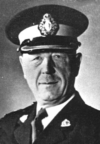
Henry A Larsen (Photo from http://freemasonry.bcy.ca/biography/larsen_h/larsen_h.html)
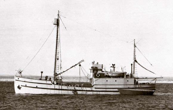
The 'St. Roch' (Photo from http://www.hnsa.org/ships/stroch.htm)
The 'St. Roch' was (indeed, is) an ice-fortified Schooner (altered to a Ketch-rigged vessel) which had a crew of nine, and was built in 1928, for the RCMP to patrol and supply in the Arctic. Its length is 31.2m (104ft), width is 7.5m (25ft), draft is 3.9m (13ft) when fully loaded, depth of hold is 3.3m (11ft), weight is 196.5 tons, and it has a displacement of 323 tons. Motorised power was provided initially by a 6-Cylinder, 150Hp (112Kw) Union diesel engine, which was later upgraded to 300Hp (224Kw) for the second journey. The hull is rounded, to allow ice to slide easily underneath, and it is built from extra-thick timbers of Douglas Fir, sheeted on the outside with Australian “Ironbark” Eucalyptus Gumwood, one of the hardest woods available. It also has a steel plate covering a very sharp Bow (previously 1ft wide), and iron shoeing around the Stern, extending several feet back. The interior hull was reinforced with thick, heavy beams to withstand the ice pressures, and the rudder could be lifted up through a special well, to avoid it being snapped off by the ice.
I.E. it is a big, tough boat, specially designed to travel in icy Arctic waters, and the perfect vessel to use for an attempt at the Northwest Passage. In fact, although it was actually the second ship to sail the Passage (after Roald Amundsen in his 70ft, 48 ton Sloop 'Gjoa', in 1903-06, using the same route), it was the first vessel to sail from West to East (Amundsen went from East to West), in 1940-42 - something thought virtually impossible at the time; the first vessel to complete the Passage in one season, in 1944 - East to West, using the deeper, more Northerly route; and the first vessel to complete the Passage in both directions.
As for the Northwest Passage, it runs across the top of Canada, from the Eastern edge of the Beaufort Sea in the West, to Baffin Bay/the Labrador Sea/Hudson Bay in the East, and the (unsuccessful) search for a way through has been going on for centuries, with European explorers trying for four hundred years to find a route that would have meant a shorter journey to the great riches of the silks and spices of Asia - the prospect of a Northern sea passage from Europe to Asia was thought worth the hardship and hazards.
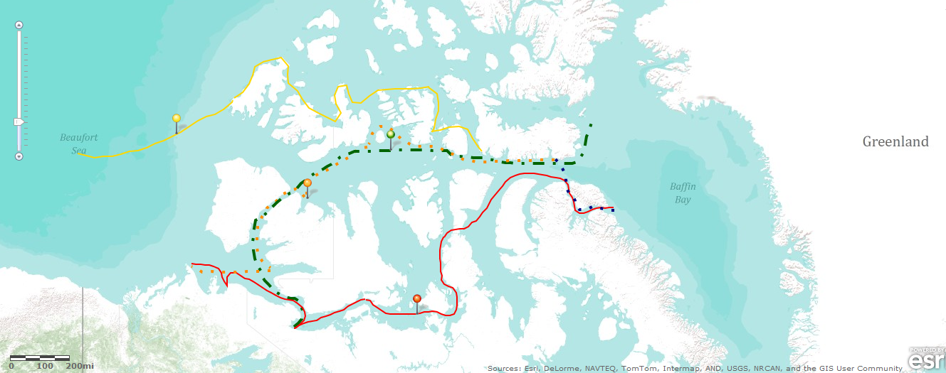
The first recorded attempt was the East-West voyage of John Cabot in 1497, and various subsequent expeditions (by, most notably, Drake, Cook, Hudson, Parry, Ross, etc.) led to the gradual mapping of the Passage, until Robert McClure (in 1854, and the first to traverse it from West to East, albeit partly by sledge) charted the last major piece. After all this, including up to the early years of the 20th Century, it was finally concluded that commercial shipping was not possible and so interest waned. However, the Passage has become commercially important again because it is now more regularly navigable, although the shortest, most Northerly route – Lancaster Sound, Barrow Strait, McClure Strait, Beaufort Sea - is the least used because heavy ice normally blocks McClure Strait. The most frequent route goes South from Barrow Strait, into Peel Sound and Victoria Strait, then along the coast to the Bering Strait, and Southerly routes are likeliest to be ice-free, but they are also generally the shallowest. (You can use the externally linked Larger Map found below to see the geographical features named)
The ‘St. Roch's’ first trip (from West to East) took about 28 months (850 days), starting from Vancouver, B.C. on June 23 1940 and ending at Halifax, N.S. on Oct 11 1942.
The 1940 season was bad, with lots of heavy ice, and they could sometimes see no water : often only small pools with no visible outlet. At times, they used “black gunpowder” (1) to crack floes. On Sep 26 1940 they were frozen in at Walker Bay on the East coast of Victoria Island, and wintered there until July 31 1941.
The Summer of 1941 was also bad with lots of ice, and they didn’t get very far, due to “...ice and violent snow squalls” (2), and a lot of solid ice, so that by Sep 11 they were jammed in by ice close to the beach at Pasley Bay, Boothia Peninsula. In fact, the boat almost capsized within the tight-packed ice :“...nearly lost the ship” (2), according to Larsen. They wintered there from Sep 15 1941 to Aug 04 1942.
During the last Summer (1942), the weather was again bad and things were not much better with regards to ice. They kept getting stuck and found many inlets jammed with ice, as well as lots of moving, loose ice, within which there was not much open water – only small leads. It was a struggle through the ice and more than once they were not certain that the ship would survive. Larsen wrote : “Many times we thought the ship would crack like a nut under the pressure.”(2)
In fact, it wasn't until 1954 that a vessel managed to cross the Passage in the same direction in a single season but Larsen didn’t think that this Southerly route was likely to be commercially viable, and the following is his overall view of the journey:
“The three seasons of the short Arctic Summers from 1940-42 had been extremely bad for navigation, the worst consecutive three I had experienced as far as ice and weather conditions were concerned, and in my remaining years in the Arctic I never saw their like. Without hesitation I would say that most ships encountering the conditions we faced would have failed. I also believe that had we missed the single opportunity we had to get out of Pasley Bay, we most certainly would still be there, in small bits and pieces.” (3)
The second trip (East to West) started at Halifax, N.S. on July 22 and ended at Vancouver, B.C. on Oct 16 1944, taking a total of 86 days (travelling 7295 miles), although actually involving 1031 hours, 34 minutes (43 days) of actual sailing.
They went the more Northerly route this time, which is freer of reefs and shallow spots, but they found lots of icebergs and a lot of broken but tightly-packed ice. From the beginning of August, they experienced heavy ice - and made slow progress - as well as lots of floe ice, and drifted in the ice-pack at one stage. They had to seek shelter at times but couldn’t determine their exact location at one point because the weather conditions were so bad. At the end of August they experienced lots of heavy, tightly-packed floes and were prevented from landing due to the ice conditions. A lot of the journey consisted of following up leads and anchoring were they could. They found the heaviest ice of the voyage at the entrance to McClure Strait, where they had to moor themselves to the ice floes, and it was only at the beginning of September that the conditions were noticeably different - so much so that it was noted : “It was really the only fine day we had during the entire passage...” (2). After that, it was back to the heavy, tightly-packed ice-fields and the bad weather, with hurricane-force winds almost capsizing the boat before they were able to find shelter. In fact, the “...season was the worst in years.” (1) (2)
However, afterwards Larsen stated that the route was “...the better of the two. This route will no doubt be used in the future.” (2); and “...I was sure this would become the Northern route of the future.” (3) He was predicting that the Northerly route would be more commercially viable but his main recommendation was to “...watch the ice movements and be in the right spot at the right time.” (1) Advice still valuable today, although, as will be seen, luck plays less of a part with modern voyages in the region, due to the dearth of dangerous ice.
Generally, though, from reading the accounts, both journeys were very tough and even the quicker, more Northerly crossing was completed more due to determination, skill and luck, than to there being lots of open-water or favourable sailing conditions. In fact, neither journey would have been attempted under normal circumstances - as Larsen himself admitted in 15 Nov 1957, in a memo to the RCMP Commissioner: “...had it not been for the war, we would never have had the occasion or opportunity to make this passage.”(4) The trips were accomplished because of the special circumstances of the Second World War, and not because of any general opening-up of the Passage at that time due to melting, etc., or to the sort of conditions which have become more prevalent in that region today. Basically, the ‘St. Roch’s’ achievements are even more remarkable and noteworthy, because they involved human endeavour against odds which were greatly stacked against them as far as the ice and weather were concerned.
(The map below shows both of the voyages of the 'St. Roch' : the first journey represented by the Red line and pin marker; the second by the Orange dashed line and pin marker. It also shows the intended route of the cruise ship 'Clipper Adventurer' [See Below] in Sep 2011 : Green dashed line and pin marker. TheYellow line and pin marker shows the ice-extent on 8 Sep 2011. The larger version can be used to see geographical names/details already mentioned)
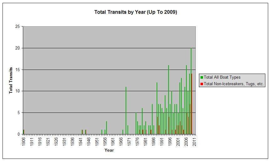
Since the first crossing by Amundsen in 1903, there have been at least 260 transits up to 2010 : 3 up to 1950; around 155 from 1951 to 2000; and at least 120 from 2001 to 2010. (Full details of political and military aspects, including lists of passages, available here, here, here, here, here, and here. This link even includes detailed instructions for those who wish to sail the passage themselves.) Some examples follow.
1977 – First single-handed yacht to transit Northwest Passage in one season: 'Williwaw', a 14.45m Bm Ketch.
1984 – First passenger cruise ship to make the transit: ‘Lindblad Explorer’.
1991-94 – First woman to paddle solo in a Kayak: Victoria Jason.
Aug 2000 – ‘St. Roch II’, an RCMP 20m twin-hulled light Aluminium catamaran (previously called ‘Nadon’) followed the original ‘St. Roch’s’ 1940-42 West to East route. It had an ice-breaker with it and the passage took three weeks : the ice-breaker was not needed, and they only saw a few ice-bergs and some small floes.
2001 – Northabout : Irish Northwest Passage Expedition, in a 15m aluminium sailing boat. (Included to celebrate my Irish ancestry !)
18 July 2003 - 'Norwegian Blue', a 13m Bermudan Cutter, became the first British yacht to transit the Northwest Passage from West to East in one season, completing the passage in two months. (Included on the recommendation of someone I met on a train to Cornwall, who knew the owner – small world, eh ?)
2007 - Sailing-vessel ‘Cloud Nine’, a 17m Bowman ketch - The first American sailing boat to complete the passage from East to West, containing possibly the oldest man to do the journey ! Completed the journey in 45 days – “There was hardly any ice”, he told the Wall Street Journal.
2007 - James Allison,sailing in the 14.5m fibreglass Bowman 'Luck Dragon', said he felt a bit of a fraud after completing the trip because there wasn’t any ice.
2007 - A lightweight 7.5m x 5m catamaran, the Babouche, successfully navigated the full length of the 5,150km (3,200-mile) waterway. “This is the first time the journey has been completed entirely by sail... Not so long ago, ...this journey would have been impossible because of the ice”.
Nov 2008 – MV Camilla Desgagnes, Super Ice-Class vessel, is the first commercial ship to sail through the Northwest Passage : delivered sea-lift cargo from the East - normally comes from the West. Did it without an ice-breaker. Waguih Rayes, General Manager – “…I didn’t see one cube of ice.” “…there was no ice whatsoever…”.
2009 - 'Silent Sound' a 12m cutter rig sailing boat completed the passage.
Sep 2010 – "The Canada Border Services Agency says 18 ships have cleared customs in Inuvik, N.W.T. - at the western end of the Northwest Passage - so far this year, and the navigation season is not even over yet. By comparison, only seven ships cleared customs there in 2009, according to the agency.”
2010 – An 11m RIB (Rigid Inflatable Boat) completes the passage.
2010 - A Russian crew aboard the 18m yacht 'Peter I' sailed around the Arctic, passing through the Northeast and Northwest Passages during one sailing season with no ice-breaker assistance. The first time in seafaring history. Or was it...
2010 - Norwegian explorer Børge Ousland and skipper Thorleif Thorleifsson onboard the sailboat ‘Northern Passage’ made the first full circle navigation of the Polar Basin. Their route took them through both the Northeast and Northwest passages. The expedition used a small trimaran made of fibreglass, with a 10Hp outboard as their only engine. ”Less than 10 years ago the first steel hulled sailboat managed to get through just one of the passages, and 100 years ago a circumnavigation would have taken six years”.
2010 - "Luxury yacht turns heads while sailing Northwest Passage".
It's obviously getting easier, but perhaps not as easy as some amateurs may imagine :
2010 – “Amateur sailors are setting course for the legendary Northwest Passage, but some are ill-equipped and unprepared for the challenges of sailing in the North, Canadian Coast Guard authorities say”.
Fancy a cruise along the Northern Northwest Passage ? Try this one next year maybe :
September 1-17, 2011 - “Out of the Northwest Passage” aboard the 'Clipper Adventurer'.
Sep 2011 – A home-made Russian boat, the trimaran 'Rus', is now heading through the Northwest Passage.
2011 – The 9.3m GPR boat 'Beelzebub II' is “...attempting a unique passage in that we plan on going much further up the West Coast of Greenland to the highest latitude possible before turning south following the coast of Ellesmere Island and instead of crossing Devon Island to the south by entering Lancaster Sound to reach Resolute which is the “traditional route” we will attempt to pass Devon Island to the North through Jones Sound, then join up with Norwegian bay to meet Northumberland Sound to sail down to Resolute from where we will evaluate the ice charts and either join up to Peel Sound or continue along the Viscount Melville Sound.”
"Interesting Fact : In May 2010, a gray whale was observed in the Mediterranean Sea off Israel and the same individual was sighted again a month later off Barcelona, Spain. It is impossible to know if this record of a single individual is indicative of a mounting reoccupation of the historic range (especially in light of receding sea ice in the Northwest and Northeast Passage) or simply represents an extraordinary event."
Etc., etc. There are plenty more stories about crossings out there, especially since the year 2000, and the following graph shows how the numbers have been increasing over the years :
(The above graph has been produced and adapted from a similar graph and the list of transits given in The Arctic - The Physical Environment : Kyle D. Christensen)
But what about the state of the ice these days ?
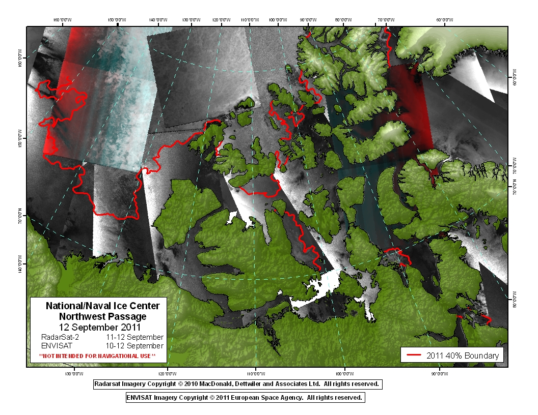
Sep 2011 - “Sea ice is now almost completely gone from the channels of the Northwest Passage, with the exception of a small strip of ice across a stretch of the Parry Channel. The southern route (Amunden's Route) is ice free. According to the Canadian Ice Service, sea ice extent in the western Parry Channel is now the lowest at this time of year since record keeping began in 1966 and very little multi-year ice remains.”
(Graphic fromhttp://www.natice.noaa.gov/press_releases/images/northwest_passage_20110912.jpg)
Oct 2010 - "The U.S. National Ice Center declared both the Northwest Passage and the Northern Sea Route open for a period during September. Stephen Howell of Environment Canada reported a record early melt-out and low extent in the western Parry Channel region of the Northwest Passage, based on analyses of the Canadian Ice Service."
Aug 2008 - “The direct route through the Northwest Passage...is currently almost free of ice, while the indirect route, called the Amundsen Northwest Passage, has been passable for almost a month. This is the second year in a row that the most direct route through the Northwest Passage has opened up.”
Summer 2008 - "This year marked the first time since satellite measurements began in the 1970s that the Northern Sea Route, also known as the Northeast Passage, and the Northwest Passage were both open at the same time for a few weeks."
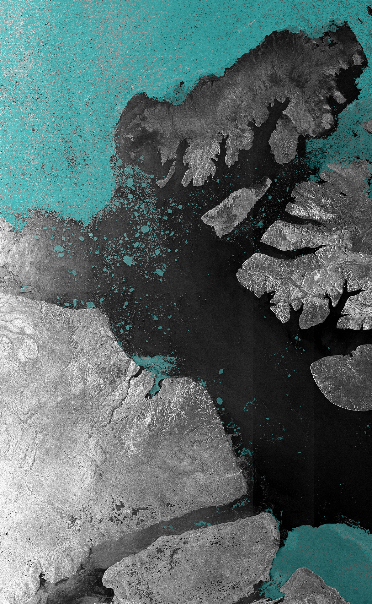
Summer 2007 - “Arctic sea ice receded so much that the fabled Northwest Passage completely opened for the first time in human memory.”
("Envisat ASAR image of the McClure Strait in the Canadian Arctic Archipelago, acquired on 31 August 2007. The McClure Strait is the most direct route of the Northwest Passage and has been fully open since early August 2007.”)
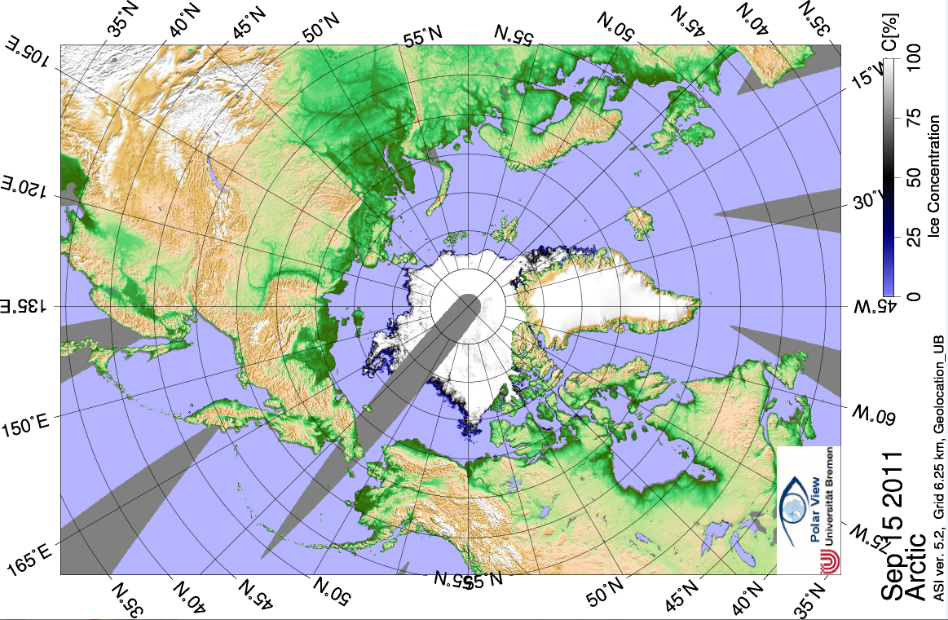
(Graphic above, from the University of Bremen, shows Arctic ice extent on Sep 15 2011)
I think it’s easy to see that conditions in the Northwest Passage these days, and the wide-ranging types of vessels that are able to pass through it, show without much doubt that no valid comparison can be made between the ‘St. Roch’s’ completions of the passage back in the 1940s and the numerous transits that can be made today – the former took a mind-set that is arguably little in evidence today (self-sacrifice, ideals, patriotism, etc.), while the latter show how virtually anyone can accomplish the passage these days.
Numbered References cited:
(1) The Conquest of the North West Passage : The Arctic Voyages of the St. Roch, 1940-44 – Inspector Henry A. Larsen, R.C.M.P
The Geographical Journal, Vol CX Nos 1-3, July – September 1947
ISSN 0016-7398
LCCN 2002227357
CODEN GGJOAR
(http://www.jstor.org/pss/1789190)
(2) The North-West Passage, 1940-42 and 1944 : The Famous Voyages of the Royal Canadian Mounted Police Schooner “St. Roch”
Sergeant Henry Larsen, F.R.G.S., Commander Edmond Cloutier, C.M.G., O.A., D.S.P.
Queen's Printer and Controller of Stationery
Ottowa, 1958
Cat. No. J62-1058
(1st Edition - 1948)
(3) The Big Ship – An Autobiography by Henry A. Larsen, in co-operation with Frank R. Sheer and Edward Omholt-Jensen.
McClelland & Stewart Ltd
Toronto
1967
(4) Why the St. Roch ? Why the Northwest Passage ? Why 1940 ? New answers to old questions.
S.D. Grant – Arctic, Vol. 46, No. 1 (March 1993), Pp 82-87
(Arctic Institute of North America)
Additional References not cited :
Plowing the Arctic
G.J. Tranter
Hodder & Stoughton Ltd
1945
Arctic Labyrinth : The Quest of the Northwest Passage
Glyn Williams
Allen Lane/Penguin
2009
Last updated on 5 October 2011 by JMurphy. View Archives


 Arguments




The first commercial ship to complete the Northwest Passage, in both senses, in the same year, was the US supertanker Manhattan in 1969.
The second one, as far as I know, was the drilling ship Canmar Explorer II in 1976.
I obviously meant "in both directions", East-to-West then West-to-East. Apologies.
MRoscio @6 & 7, the Manhattan was accompanied by an icebreaker, the USCGC Northwind, on its westward passage, and by another icebreaker, the USCGC Staten Island on its eastward passage. At some unspecified stage, it also had additional assistance by the CCGS Louis S. St-Laurent. This despite having been modified to itself be an icebreaker. Likewise, the Canmar Explorer II was also accompanied by an icebreaker, the CCGS Louis S. St-Laurent.
Given that multiple commercial ships and hobby craft transit the Northwest Passage every year now, without icebreaker assistance, I am not sure what your point is.