


 Arguments


Linking Weird Weather to Rapid Warming of the Arctic
Posted on 13 April 2012 by Daniel Bailey
NOTE: This post is reprinted from an article originally appearing in Yale Environment 360, by permission of the author, Dr. Jennifer Francis and Yale Environment 360.
Does it seem as though your weather has become increasingly “stuck” lately? Day after day of cold, rain, heat, or blue skies may not be a figment of your imagination. While various oceanic and atmospheric patterns such as El Niño, La Niña, and the North Atlantic Oscillation have been blamed for the spate of unusual weather recently, there’s now a new culprit in the wind: Arctic amplification. Directly related to sea-ice loss and earlier snowmelt in the Far North, it is affecting the jet stream around the Northern Hemisphere, with potentially far-reaching effects on the weather.
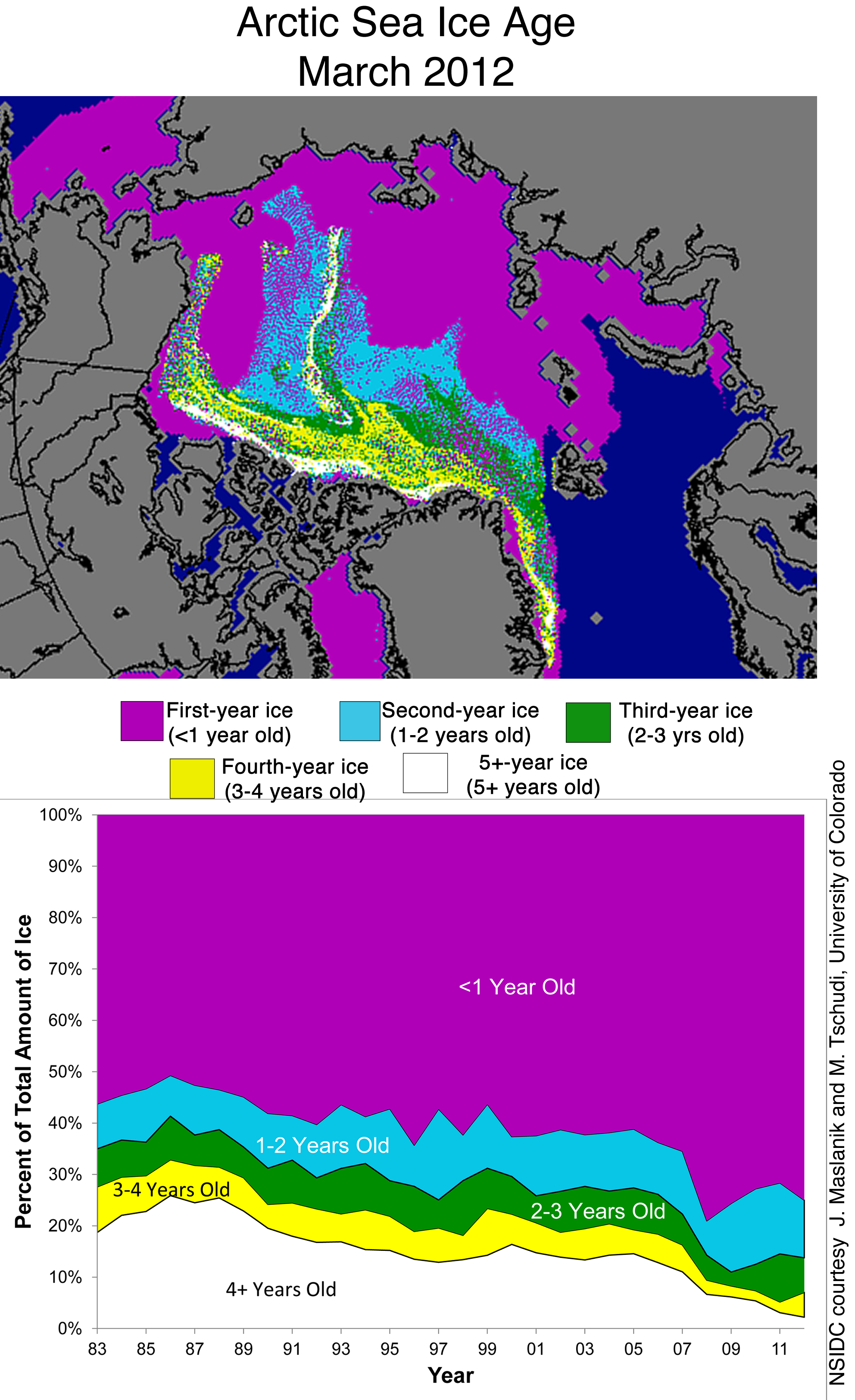
Arctic amplification describes the tendency for high Northern latitudes to experience enhanced warming or cooling relative to the rest of the Northern Hemisphere. This heightened sensitivity is linked to the presence of snow and sea ice, and the feedback loops that they trigger. For example, as sea ice retreats, sunshine that would have been reflected back to space by the bright ice is instead absorbed by the ocean, which heats up, melting even more ice. As the world has warmed since the fossil-fuel revolution after World War II, Arctic temperatures have increased at more than twice the global rate. A dramatic indicator of this warming is the loss of Arctic sea ice in summer, which has declined by 40 percent in just the past three decades. The area of lost ice is about 1.3 million square miles, or roughly 42 percent of the area of the Lower 48 United States.
Extra heat entering the vast expanses of open water that were once covered in ice is released back to the atmosphere in the fall. This has led to an increase in near-surface, autumn air temperatures of 2 to 5 degrees C (3.6 to 9 degrees F) over much of the Arctic Ocean during the past decade.

Fig 1. This graphic shows how near-surface air temperatures over much of the Arctic Ocean in autumn have increased by 2 to 5 degrees C (3.6 to 9 degrees F) in the past decade, compared with the previous 30 years. That increased heat, related in part to the loss of sea ice, is changing some weather patterns over the Northern Hemisphere. (Courtesy of National Center for Environmental Prediction and National Center for Atmospheric Research.)
All that extra heat being deposited into the atmosphere cannot help but affect the weather, both locally and on a large scale. And there are growing indications that some weather phenomena in recent years — such as prolonged cold spells in Europe, heavy snows in the northeastern U.S. and Alaska, and heat waves in Russia — may be related to Arctic amplification.
But if so, how does it work?
The Arctic region is of course colder than the temperate zones, and it is this difference in temperature that propels the west-to-east river of fast-moving air known as the jet stream. This atmospheric feature separates warm air to its south from cold air to the north, and tends to follow a wavy path as it flows around the Northern Hemisphere between about 30 degrees N and 60 degrees N. It usually resides near the altitude where jets fly, hence its name. As high latitudes warm more than mid-latitudes, however, this north-south temperature difference weakens, which has two impacts on the jet stream.

Fig 2. This graphic depicts how the drop in high-altitude winds in autumn over the past 30 years has closely tracked the decline in Arctic sea ice (dashed line). The rapid warming of the Arctic has reduced the temperature difference between the Far North and temperate regions, slowing down the jet stream and leading to more persistent, or “stuck,” weather patterns. (Jennifer Francis, based on data from the National Center for Environmental Prediction, National Center for Atmospheric Research, and National Snow and Ice Data Center)
The first effect is to slow the west-to-east speed of the jet stream, a phenomenon that already appears to be occurring. Upper-level winds around the Northern Hemisphere have slowed during autumn, from October to December, which is exactly when sea ice loss exerts its strongest effect on the north-south temperature gradient. Some regions exhibit even larger drops in wind speed, such as over North America and the North Atlantic, where winds have slowed by about 14 percent since 1980.

Fig 3. The warming of the Arctic appears to be changing the trajectory of the jet stream in certain seasons, leading to more persistent weather patterns. The solid line represents a typical jet stream trajectory, and the dashed line represents the expected northward elongation of the waves in the jet stream in response to Arctic warming. (Courtesy of Jennifer Francis, Rutgers University)
Theory tells us that a decrease in the west-east flow tends to slow the eastward progression of waves in the jet stream. Because these waves control the formation and movement of storms, slower wave progression means that weather conditions will be more persistent. In other words, they will seem more “stuck.” This effect appears to play an important role mainly in autumn, because as sea ice reforms in winter, the north-south temperature difference gradually returns to more normal values.
The second way that Arctic amplification is expected to influence the jet stream and our weather is by increasing the “waviness” of the jet stream. Because of Arctic amplification, the northern peaks of waves, called ridges, will experience more warming than the southward dips, called troughs. This is expected to cause the ridges to stretch northward, which will increase the size of the waves. Larger swings in the jet stream allow frigid air from the Arctic to plunge farther south, as well as warm, moist tropical air to penetrate northward. These wavy flows often lead to record-breaking temperatures. Meteorologists have also known for a long time that larger jet-stream waves progress eastward more slowly, as will the weather systems associated with them. Consequently this represents another mechanism that will cause weather conditions to linger.
Increased waviness seems to be occurring during summer, as well; but instead of sea ice loss, the culprit appears to be the progressively earlier melt of snow on Arctic and sub-Arctic land in the spring.

Fig 4. Spring Northern Hemisphere Snow Extent (courtesy Rutgers University Global Snow Lab)
As snow disappears, bare soil is exposed to the strong spring sunshine earlier, which allows it to dry and warm sooner. This effect is at least partly responsible for the approximately 2 degrees C of warming over high-latitude land areas since the mid-1980s. This heat contributes to Arctic amplification during summer, which is expected once again to stretch ridges northward, increase waviness, and promote sluggish weather.
There have been many examples of “stuck” weather patterns during the past few years. Deep troughs in the jet stream hung over the U.S. east coast and Western Europe during the winters of 2009/2010 and 2010/2011, bringing a seemingly endless string of snow storms and teeth-chattering cold. In the early winter of 2011/2012, in contrast, these same areas were under ridges, or northward bulges of the jet stream, which brought unusually warm and snowless conditions over much of North America. At the same time, however, a deep trough sat over Alaska, dumping record snows. In early February this year, the jet stream plunged unusually far southward over Europe, bringing frigid Arctic air and snow to some areas that hadn’t seen those conditions in over half a century. During summer, persistent weather patterns are responsible for droughts and heat. The record heat waves in Europe and Russia in the past several years have been linked to early snowmelt in Siberia, and a sluggish high-pressure area caused last summer’s sweltering conditions in the south-central U.S.
While it’s difficult to point the finger at Arctic amplification in causing any of these weather events, they are the types of phenomena that are expected to occur more frequently as the world continues to warm and the Arctic continues to lose its ice. Further research may find ways to predict which regions will experience which conditions. But in the meantime, it’s increasingly likely that the weather you have today will stick around awhile.
ABOUT THE AUTHOR: Jennifer Francis is a research professor at the Institute of Marine and Coastal Sciences at Rutgers University, where she studies Arctic climate change and the link between Arctic and global climates. She has authored more than 40 peer-reviewed publications on these topics. She was also the co-founder of the Rutgers Climate and Environmental Change Initiative.


 0
0  0
0 it looks like the long term trend is still positive. Although variable, this past winter's AO index was mostly positive. See http://www.cpc.ncep.noaa.gov/products/precip/CWlink/daily_ao_index/ao.sprd2.gif
 Arctic amplification describes difference in rate of warming between the Arctic and the rest of the planet. As you can see, there is no significant difference before about 1980, but after 1995 the difference goes through the roof.


 Arctic Sea Ice Concentration Bulletin
 Arctic Sea Ice Drift Bulletin
 [Source]
By combining the first two we can see that the Bering Sea, Sea of Okhotsk, Chukchi Sea, Hudson Bay, Baffin Bay, Barents Sea and Kara Sea will all readily melt out by summer insolation max in late June or early July.
The East Greenland Sea will also largely melt out by then, except for ice being advected out the Fram (which quickly meets its doom in the relatively hot waters of the North Atlantic).
[Source]
By combining the first two we can see that the Bering Sea, Sea of Okhotsk, Chukchi Sea, Hudson Bay, Baffin Bay, Barents Sea and Kara Sea will all readily melt out by summer insolation max in late June or early July.
The East Greenland Sea will also largely melt out by then, except for ice being advected out the Fram (which quickly meets its doom in the relatively hot waters of the North Atlantic).


Comments