Climate Science Glossary

Term Lookup

Enter a term in the search box to find its definition.

Settings

Use the controls in the far right panel to increase or decrease the number of terms automatically displayed (or to completely turn that feature off).

Term Lookup

Settings


All IPCC definitions taken from Climate Change 2007: The Physical Science Basis. Working Group I Contribution to the Fourth Assessment Report of the Intergovernmental Panel on Climate Change, Annex I, Glossary, pp. 941-954. Cambridge University Press.

Home Arguments Software Resources Comments The Consensus Project Translations About Support

Twitter Facebook YouTube Mastodon MeWe

RSS Posts RSS Comments Email Subscribe


Climate's changed before
It's the sun
It's not bad
There is no consensus
It's cooling
Models are unreliable
Temp record is unreliable
Animals and plants can adapt
It hasn't warmed since 1998
Antarctica is gaining ice
View All Arguments...


Username
Password
New? Register here
Forgot your password?

Latest Posts

Archives

John Nielsen-Gammon Comments on Continued Global Warming

Posted on 1 May 2012 by dana1981

John Nielsen-Gammon, Texas State Climatologist and a Professor of Atmospheric Sciences at Texas A&M University, has a nice article published in the Houston Chronicle regarding the misconception that global warming has stopped based on global surface temperatures.

"It’s common knowledge among those who follow such things that global temperatures have not gone up very much in the past several years.  This has caused many to believe that the recent lack of warming contradicts what climate models say should happen in response to the increasing Tyndall gases.  This, in turn, has provoked the counterargument that the Earth is still warming, just on a longer time scale, or that the recent period is too short to yield statistically significant results."

Nielsen-Gammon goes on to perform a simple analysis of the global surface temperature data, categorizing each year as an El Niño, La Niña, or El Niño Southern Oscillation (ENSO)-neutral year.

"I decided to take a simple approach at looking at the effect of ENSO.  Using GISTemp Land/Ocean Index values and Niño 3.4 values, I computed 12-month running averages of Niño 3.4 and compared them to the average GISTemp values at lags of 0, 3, and 6 months.  Foster and [Rahmstorf] used a [different] ENSO index and found optimal lags between 2 and 5 months.  So one would guess that a 3-month lag would fit the data best in my case, and indeed it did.

The normal threshold for El Niño or La Niña, as applied by the Climate Prediction Center, is for five consecutive months of at least 0.5 C above or below normal in a key region of the tropical Pacific.  For working with annual data, I decided to call an annual average above 0.5 C an El Niño and an annual average below -0.5 C a La Niña.  Then I plotted it up, color-coding each year for whether it was El Niño, La Niña, or neither (neutral).  Here’s the result:"

John N-G GISTEMP

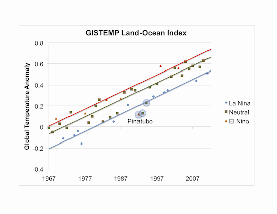
In this figure, Nielsen-Gammon has added linear trend lines to each ENSO category, and he notes that they all correspond to warming trends of about 0.16°C per decade.  Additionally, the recent ENSO neutral years have more or less followed the ENSO neutral warming trend line, as has been the case for recent El Niño and La Niña years.

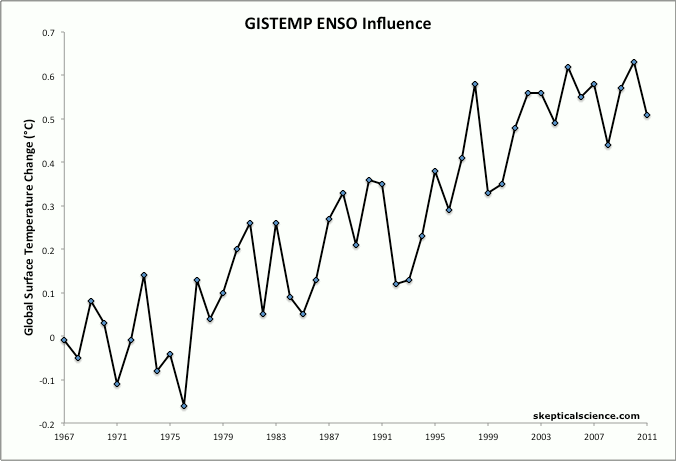
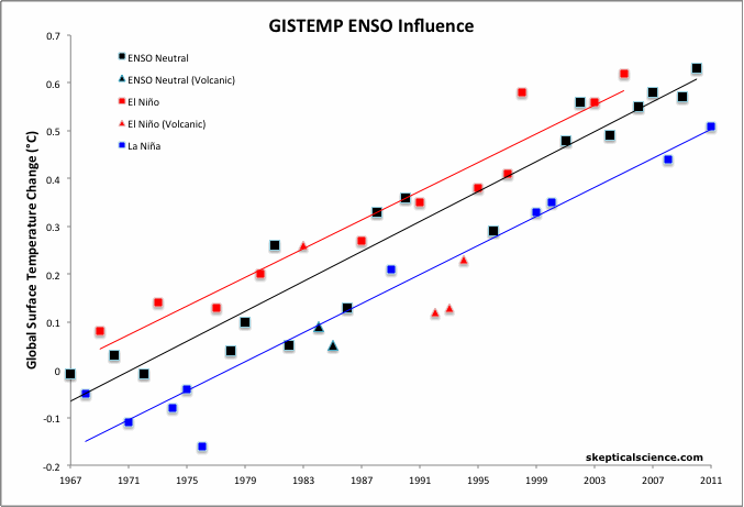
We took a very similar approach, but used the Multivariate ENSO Index (MEI) instead of Niño 3.4 values.  The MEI incorporates six main observed variables over the tropical Pacific: sea-level pressure, zonal and meridional components of the surface wind, sea surface temperature, surface air temperature, and total cloudiness fraction of the sky.  We also used GISTEMP global annual surface temperature anomalies, and a 4-month lag between MEI and GISTEMP, consistent with the results in Foster & Rahmstorf (2011).  El Niño and La Niña years were classifed as those with MEI values of greater than 0.5 and less than -0.5, respectively (which correspond to warming or cooling effects of ~0.04°C or more on the annual global surface temperature anomaly, according to Foster & Rahmstorf).  An MEI with an absolute value of less than 0.5 was classifed as an ENSO-neutral year. 

In this animated GIF we can see the effect of this change in perspective, starting with simple GISS global surface temperature anomalies in the first frame, adding in the layer of information regarding the ENSO influence on each data point in the second frame, and adding the linear trend for El Niño, ENSO neutral, and La Niña years in the third frame.

 GISS ENSO animation

The results are quite similar to Nielsen-Gammon's.  For the El Niño and ENSO neutral trends, we excluded the three years influenced by the El Chichón volcanic eruption (1983-1985) and the Mount Pinatubo volcanic eruption (1992-1994).  As in Nielsen-Gammon's analysis, we begin ours in 1967 in order to avoid the influence of the Mount Agung volcanic eruption.

With those points excluded, all three ENSO categories have linear trends of 0.15 to 0.16°C per decade over the past 44 years.  In recent years, we also see that the annual temperature anomalies in each category have closely followed their long-term linear trends, as shown by the final frame of the GIF animation above:

GISTemp ENSO trends

Nielsen-Gammon continues with his analysis:

"The spacing between the lines is a good measure of the impact of El Niño and La Niña.  All else being equal, an El Niño year will average about 0.2 C warmer globally than a La Niña year.  Each new La Niña year will be about as warm as an El Niño year 13 years prior.

So we see a couple of recent La Niñas have caused the recent global temperature trend to level off.  But be honest: doesn’t it seem likely that, barring another major volcanic eruption, the next El Niño will cause global temperatures to break their previous record?  Doesn’t it appear that whatever has caused global temperatures to rise over the past four decades is still going strong?

So about that lack of warming:  Yes, it’s real.  You can thank La Niña.

As for whether this means that Tyndall gases are no longer having an impact: Nice try."

We similarly find that an average El Niño year will be approximately 0.1°C warmer than an ENSO-netural, and 0.2°C warmer than a La Niña year, all else being equal.  Due to the human-caused global warming trend, as Nielsen-Gammon notes, an average La Niña year now is approximately as warm as an average El Niño year was 10-15 years ago.

Over the past 13 years, based on our categorizations, there have been four La Niña events (two in the top ten strongest over the past 44 years) vs. just two El Niño years, both of which were relatively weak, with the last one happening seven years ago.  So Nielsen-Gammon is correct to note that some of the slowed surface temperature warming over the past decade can be attributed to La Niña, although there have been other influences at play as well, such as human aerosol emissions.  However, due to the preponderance of La Niñas, heat has been funneled to the deeper ocean layers, and is poised to come back and haunt us in future El Niño events.

0 0

Printable Version  |  Link to this page

Comments

Comments 1 to 28:

  1. Thank you - this is a good way to demonstrate the trend - particularly as so many people who are still (genuinely) sceptical seem to be unable to read graphs. (In my experience if someone says a chart shows a downtrend some people believe them, even when the trend is clearly upwards). FYI, the latest (24 April 12) ENSO wrap up from the Australian Bureau of Meteorology states:
    "Some, but not all, climate models note an increased risk of El Niño conditions evolving during winter or spring. Historically, about 70% of two-year La Niña events are followed by neutral or El Niño phases."
    If so, maybe next year will set another global surface temperature record.
    0 0
  2. When the temperature record is shown like this, you can really see the warming is continuous and that it is inline with CO2. Lets hope the media outlets start becoming more truthful about it. All we want is a couple of green power stations.
    0 0
  3. If a La Nina is distributing heat into the ocean instead of the atmosphere, then sea level should rise more rapidly during a La Nina than during an El Nino. That is, fluctuations of sea level and surface temperature from their long-term trends ought to be anticorrelated; but they don't seem to be. Can someone explain this?
    0 0
    Moderator Response: (Rob P) See explanation here:Why did sea level fall in 2010?
  4. Jeff T Sea level tends to fall during La Nina. I think this is related to precipitation moving water from the oceans to the land (note, for example the big floods in Australia).
    0 0
  5. Jeff T, read this post and post any further questions in the comment stream that follows the post. Note that there is also an intermediate article in addition to the basic article. Short answer: evaporation > thermal expansion in the short run.
    0 0
  6. One thing that makes me a little uncomfortable with this analysis, is that most ENSO monitoring organizations consider the NH winter of 2006/2007 and the NH winter of 2009/2010 as El Nino events. Neither El Nino event shows in either analysis above, because the El Nino event impacts were partitioned into the calendar years, thus downgrading each event into the Neutral category. I wonder if annual cycles using July to June would give stronger and more accurate correlations to ENSO events? Or even more accurately, use monthly anomalies, and annualize the trends for each ENSO period (El Nino, La Nina, and ENSO Neutral)... I know this complicates the analysis, but the current analysis is open to criticism for ignoring the two most recent El Nino events.
    0 0
  7. The 2009-2010 El Niño (despite being just moderate), was the strongest of the last decade, and instead in 2005 ENSO was just neutral-to warm. Why 2010 is shown as "ENSO neutral"and 2005 as "El Niño"?
    0 0
  8. From Peru @7, N-G used annual averages as stated above. Although the early part of 2010 featured a moderate El Nino, the later part featured a strong La Nina. Using annual averages that would cancel out to make a neutral year.
    0 0
  9. zinfan94, From Peru - Also note that a 4-month lag of the ENSO state was used, corresponding to the Foster and Rahmstorf lag findings. That, and the use of yearly averaging, need to be taken into consideration when looking at the ENSO/temperature relationship.
    0 0
  10. The purpose here is to see what effect ENSO had on each annual temperature anomaly. Since the annual temperature anomaly is defined as the average anomaly from Jan through Dec (or sometimes Dec through Nov), we only care about the ENSO influence on those 12-month spans. So while a given year like 2010 may have had a fairly strong El Nino event, the overall effect of ENSO on that year's temeperature may put it in the ENSO neutral category. We could do the analysis defining a year as July through June as zinfan @6 suggests, but annual temperature anomalies are not defined as July through June so this wouldn't be a very useful analysis.
    0 0
  11. Let's not obscure this result with lags and competing averaging periods. This doesn't get much simpler: All three categories are warming at approximately the same rate. The last 4 neutral years are spot on this trend. Even the last two la Ninas are warmer than most of the prior el Ninos. 'Skeptics' need to stop looking at their favorite year (1998) as if that one data point is the whole story.
    0 0
  12. 11, Muon, Yes... but I have a strong feeling that we'll too soon be able to do away with that particular mantra. 1998 will no longer be an acceptable choice, and they'll have to wait at least a few years before they can start saying "But 2013 (or whenever) was the warmest year ever, and temperatures have been dropping since." There's no telling when the next El Niño is going to hit, or how strong it will be, but I'd give it an 80% chance at least of easily topping 1998, 2005, and 2010. The fact is that the globe has warmed, and an even moderate El Niño at this point will do the trick. [Oops! Did I say trick? No, not that kind of trick! It's not a trick! Dang those deniers and their tricks. Aargh! I did it again!] And a whopper of an El Niño is going to silence a lot of people (although they'll try to blame it on natural cycles, and to say that it was just a really big El Niño and has nothing at all to do with global warming in general).
    0 0
  13. It's worth noting that 1998 had the second-largest El Nino influence, behind 1983. 1983 is an interesting one because it had the competing effects of a whopper El Nino and the El Chicon eruption. The El Nino won out, and it fell right on the long-term El Nino trend line. And 2010 showed that even ENSO-neutral years can be sufficient to match or break the annual temperature record in the current day, thanks to the man-made global warming signal. Which bodes well for my prediction that 2013 will break the record once again.
    0 0
  14. Dana, Simply by following the neutral, El Niño and La Niña lines in the graph on this post shows that the only thing that will prevent you from being right are: 1) A large volcanic eruption of the sort that reduces insolation 2) Yet another La Niña (something that can happen, but hasn't happened since 1974-1976 (three successive La Niña years). 3) All of climate science is completely and totally wrong, and you and they, in spite of all of the evidence to the contrary, don't have the faintest clue of what is happening. The other scenarios... even with a quiet sun, high Chinese aerosol emissions, and ENSO neutral conditions suggest that 2013 will certainly be warmer -- amazingly warmer if an El Niño kicks in. So 2013 will be an interesting year. Almost as interesting when 2020 comes around and people are really freaking out, and wondering WTF they were thinking when they were ignoring or denying things in 2010.
    0 0
  15. Sphaerica - on #1 I covered my butt and noted that a significant volcanic eruption would nullify my prediction. Regarding #2, that would require 3 consecutive years of La Nina conditions, which is very rare. The most recent La Nina appears to be ending right now, in fact. If we enter an El Nino phase within the next few months, that will be perfectly timed to influence 2013 surface temps. I'm not too worried about #3 :-)
    0 0
  16. Hmmmph. John N-G used the exactly process I employed a while back to determine the likely magnitude of the next global temperature record. I even constructed a graph with the three regressions, an an x-marks-the-spot for Pinatubo. Guess I shouldn't have hidden that little light under a bushel. I like the animation. Perhaps it might be possible to add a sequence at the end where you drop out in turn two of the three regressions, so that observers can 'see' the jump from La Niña to El Niño.
    0 0
  17. A good idea in a future post might be to define what constitutes ENSO, as there are different measures. From Peru (#7) cites ONI, the 3-month running mean of the 3.4 region. John Nielsen-Gammon also uses the 3.4 region, but with 12-month averages and a lag. F&R did the same calculations with MEI and SOI. While all correlate (SOI inversely), SOI is notably different in that the 2009-2010 el Nino-ish conditions are very mild (weaker than 2005) and the recent couple of years of la Ninas are collectively the most intense in the 60-year record. F&R I think determined the conclusions of their study don't change when using either measure, but it's relevant in putting 2010-present in context. What I like about the Nielsen-Gammon approach, that while less precise and comprehensive than F&R, it's an easy-to-understand visual. There's no real "black box" effect among a lay audience wondering how adjusted temperatures are done. Temperature during la Nina years are trending warmer too.
    0 0
  18. I am wondering how this study of ENSO effect 'speaks to' the impact of aerosal dampening and/or 700-2000 deep 'hiatus' periods vis-a-vis surface temps? Do the findings somehow account for the 'missing' heat of the last 10-13 or so years or is it simply that all 3 plots (La Nina, ENSO neutral, and El Nino) would be 'shifted higher' without the aerosal and/or ocean hiatus effects?
    0 0
  19. dagold - The 'hiatus' periods are the ENSO events (heat going more/less into the oceans rather than the atmosphere), so this analysis speaks directly to that variation. With respect to aerosols, declines in insolation and the like, keep in mind that CO2 forcing is increasing faster than exponential right now, meaning GHG forcing is greater than linear in rise. I suspect that forcing balances out dimming and insolation to such an extent that it's going to be difficult to isolate anything more complex than linear temperature increases - given the noise level in the surface temperature signal. At least, not without a longer period...
    0 0
  20. dana @ 15 Question for you ... it appears that we cannot predict with any certainty whether there will be an El Nino, La Nina, or a an ENSO neutral year. I realize that uncertainty is not the same thing as true randomness, but what leads you to believe that a third La Nina after two previous ones is less likely than otherwise, any more than the odds of flipping a true coin heads for the tenth time after nine previous heads would be any less than 50%? Do you believe that there is a pattern, and we simply haven't figured it out yet, and what leads you to that conclusion? Best wishes, Mole
    0 0
  21. Old Mole. See sout@1. "....the latest (24 April 12) ENSO wrap up from the Australian Bureau of Meteorology states: "Some, but not all, climate models note an increased risk of El Niño conditions evolving during winter or spring. Historically, about 70% of two-year La Niña events are followed by neutral or El Niño phases." So the likelihood according to BOM is 70% that this year will be neutral or El Nino if it follows the historical patterns.
    0 0
  22. Old mole @20 - there are ENSO predictions which go about 9 months into the future, so we do have some idea how it will change in the near term. This is discussed in my post linked in comment 13.
    0 0
  23. dagold/KR I don't think KR's reply is quite accurate. El Nino/La Nina is associated with changes in warm and cool water, particularly across the Pacific, down to depths of several hundred meters. The Hiatus periods identifed by Meehl et al and showing up in OHC data are comparing roughly 0-700 M vs 0-2000 m. And they operate over timescales longer than ENSO - a decade rather than a year or so. So it is better to regard the hiatus periods as being akin to a deeper and slower ENSO cycle. And that this isn't confined just to the Southern Pacific. They may be related. The Hiatus period cycle could certainly impact on the ENSO cycle, changing the dynamics of it. But they aren't the same thing. But related, possibly.
    0 0
  24. Glenn Tamblyn - Quite right, ENSO shifts generally have shorter time-scales, although over the last decade the ENSO pattern matches the apparent decadal slowdown in surface temperatures. Reminds me of grad school - Not ready to graduate? Read another paper! Clearly I need to read some more...
    0 0
  25. These El Nino-related arguments seem quite plausible at explaining year-to-year variations in warming trends. But one thing puzzles me as a relative layman in this field: It seems like the oceans have a huge capacity to buffer and blunt the effects of GW, potentially for many years to come. But the kinetics of heat transfer into the oceans seem slow and variable - otherwise why would these ENSO patterns have such an effect on apparent warming. So why is heat transfer into the oceans apparently so slow and inconsistent? (I know there's probably not a simple answer to this, but if anyone is looking for a subject for a future topic post...)
    0 0
  26. johnd2 - the transfer of heat into the ocean is through one means only - sunlight. Greenhouse gases trap heat in the ocean in much the same way that they trap heat in the atmosphere - via slowing the loss of energy (heat) out of the ocean. It is by this mechanism that the oceans warm over time. See SkS post: How Increasing Carbon Dioxide Heats The Ocean As counter-intuitive as it may seem, El Nino is when the Earth loses energy -as heat is given up to the atmosphere and is eventually radiated away to space, and La Nina is when the Earth gains energy - as heat is buried in the subsurface layers of the western tropical Pacific and upwelled cold water, on the other side of the ocean, is brought to the surface to be heated by the sun. The global picture is more complex, but that's the basic gist of ENSO's effects.
    0 0
  27. johnd2 - The rate of ocean warming is actually fairly steady, as discussed in multiple threads here, such as The Earth is Warming. But if the ocean heat absorption varies only a tiny bit (proportionally) in the presence of an ongoing forcing imbalance, that amount of energy can cause a quite large variation in the atmosphere. The atmospheric temperature delta then becomes the 'tail' on the ocean variation 'dog'.
    0 0
  28. N-G has a new post up at his website, responding to comments about the post in the thread. http://blog.chron.com/climateabyss/2012/05/lack-of-warming-a-followup/
    0 0

You need to be logged in to post a comment. Login via the left margin or if you're new, register here.


The Consensus Project Website

THE ESCALATOR

(free to republish)


© Copyright 2024 John Cook
Home | Translations | About Us | Privacy | Contact Us