Climate Science Glossary

Term Lookup

Enter a term in the search box to find its definition.

Settings

Use the controls in the far right panel to increase or decrease the number of terms automatically displayed (or to completely turn that feature off).

Term Lookup

Settings


All IPCC definitions taken from Climate Change 2007: The Physical Science Basis. Working Group I Contribution to the Fourth Assessment Report of the Intergovernmental Panel on Climate Change, Annex I, Glossary, pp. 941-954. Cambridge University Press.

Home Arguments Software Resources Comments The Consensus Project Translations About Support

Twitter Facebook YouTube Mastodon MeWe

RSS Posts RSS Comments Email Subscribe


Climate's changed before
It's the sun
It's not bad
There is no consensus
It's cooling
Models are unreliable
Temp record is unreliable
Animals and plants can adapt
It hasn't warmed since 1998
Antarctica is gaining ice
View All Arguments...


Username
Password
New? Register here
Forgot your password?

Latest Posts

Archives

Sea level rise: the broader picture

Posted on 30 August 2010 by Doug Bostrom

Sea level rises as ice on land melts and as warming ocean waters expand. Sea level rise mutually corroborates other evidence of global warming as well as being a threat to coastal habitation and environments.

The blue line in the graph below clearly shows sea level as rising, while the upward curve suggests sea level is rising faster as time goes on. The upward curve agrees with global temperature trends and with the accelerating melting of ice in Greenland and other places.

Because the behavior of sea level is such an important diagnostic aid for tracking climate change, skeptics seize on the sea level record in an effort to cast doubt on this evidence. Sea level bounces up and down slightly from year to year so it's possible to cherry-pick data falsely suggesting the overall trend is flat, falling or linear. You can try this yourself. Starting with two closely spaced data points on the graph below, lay a straight-edge between them and notice how for a short period of time you may create almost any slope you prefer, simply by being selective about what data points you use. Now choose data points farther apart. Notice that as your selected data points cover more time, the more your mini-graph reflects the big picture. The lesson? Always look at all the data, don't be fooled by selective presentations.

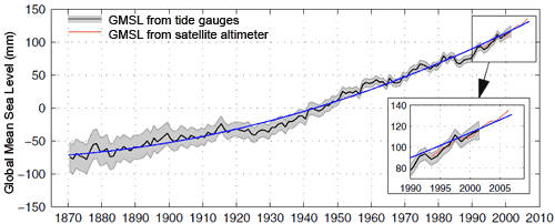
( graph from Church 2008 )

Other skeptic arguments about sea level concern the validity of observations, obtained via tide gauges and more recently satellite altimeter observations.

Tide gauges must take into account changes in the height of land itself caused by local geologic processes, a favorite distraction for skeptics to highlight. Not surprisingly, scientists measuring sea level with tide gauges are aware of and compensate for these factors. Confounding influences are accounted for in measurements and while they leave some noise in the record they cannot account for the observed upward trend.

Various technical criticisms are mounted against satellite altimeter measurements by skeptics. Indeed, deriving millimeter-level accuracy from orbit is a stunning technical feat so it's not hard to understand why some people find such an accomplishment unbelievable. In point of fact, researchers demonstrate this height measurement technique's accuracy to be within 1mm/year. Most importantly there is no form of residual error that could falsely produce the upward trend in observations.

As can be seen in an inset of the graph above, tide gauge and satellite altimeter measurements track each other with remarkable similarity. These two independent systems mutually support the observed trend in sea level. If an argument depends on skipping certain observations or emphasizes uncertainty while ignoring an obvious trend, that's a clue you're being steered as opposed to informed. Don't be mislead by only a carefully-selected portion of the available evidence being disclosed.

Current sea level rise is after all not exaggerated, in fact the opposite case is more plausible. Observational data and changing conditions in such places as Greenland suggest if there's a real problem here it's underestimation of future sea level rise. The IPCC synthesis reports offer conservative projections of sea level increase based on assumptions about future behavior of ice sheets and glaciers, leading to estimates of sea level roughly following a linear upward trend mimicking that of recent decades. In point of fact, observed sea level rise is already above IPCC projections and strongly hints at acceleration while at the same time it appears the mass balance of continental ice envisioned by the IPCC is overly optimistic ( Rahmstorf 2010 ).

This post is the Basic version (written by Doug Bostrom) of the skeptic argument "Sea level rise is exaggerated". We're currently writing plain English versions of all the skeptic rebuttals. If you're interested in helping with this effort, please contact me.  

0 0

Printable Version  |  Link to this page

Comments

1  2  Next

Comments 1 to 50 out of 80:

  1. "Don't be mislead by only a carefully-selected portion of the available evidence being disclosed." They mostly don't bother with the graphs Doug. It is enough for the Murdoch media empire to send a middle-aged surfer to, say, Bondi Beach, and have him say that the beach doesn't look any different to what it did when he was a child. Now, that disproves all those silly measurements and graphs doesn't it? Just good common sense from a member of the public - who needs science? It's this kind of stuff that makes me doubtful that these very well-intentioned simple language arguments, as well done as they are, will make any difference to public discourse. Deniers, egged on by Rupert, will keep denying in the face of all and any evidence you throw at them. As can be seen on SS threads as well as elsewhere.
    0 0
  2. This is basic version??? It is much too wordy and uses 'high-falutin' words like 'corroborate'. And what is "mutually corroborates" supposed to mean, anyway? It looks like the author thinks that sea-level rise confirms global warming, while at the same time, global warming confirms sea-level rise. But this is metaphysical impossibility (see http://plato.stanford.edu/entries/causation-metaphysics/ under 'Direction'). On a simpler note, am I the only one to notice that "Current sea level rise is after all not exaggerated, in fact the opposite case is more plausible" is a run-on sentence?
    0 0
  3. Rupert has just wired me the first 50% of our agreed sum and so here we go.... That's nice David, you're right in saying that two poorly defined observations within the space of one lifetime are not enough to really determine anything and thankyou doug for your article that didn't cover our enlightening discussion a couple of months back. You remember the discussion where you tried to discredit me by comparing my lack of credentials against Donnelly's and then claimed that I therefore had nothing to say? You also misunderstood me in quite an amateur fashion and failed to understand the points I was making about the poor quality of work done in understanding paleo sea level rise? You see David what you don't realise is that much of the concern over the current sea level rise is based on comparisons to the past. We can't really say if the current sea level rise (and indeed global temperature, which is supposed to be driving the sea level rise) is unprecedented due to the lack of any really reliable paleo data. I encourage you to look into this yourself and do be careful of the deluded assertions of the true believers who write articles like that above without the competence or desire to critique the work put forward by supposed experts. Peter and others then took over trying to claim that I didn't have any evidence to suggest that there are any real drivers in the not too distant past to reproduce the current levels of SLR. Well that's a discussion I haven't had the time to have with them yet but I can say that i had a quick look a couple of months back and what i found in terms of the quality of paleo temperature records and also their comparison to modern temperatures gave me quite the confident grin. Yours truly David, from someone who actually knows what they're talking about :) Oh and peter, to claim that you are the ultimate authority on what is recognisable statistics or science was an absolute gem :D thanks for the laughs....
    0 0
  4. "Metaphysical impossibility?" High falutin' indeed, Matt! You're thick-skinned so I'll in turn suggest you check the definition of "corroborate." :-) I'd say "mutually" is unnecessary and could well be discarded. As to run-on sentences, your calibration as a grammarian may insist that "in fact" is not technically a coordinating conjunction but I'm quite happy with the result. If I'm besieged by grammar grumblings over this license perhaps I'll change the sentence.
    0 0
  5. daniel - you might want to look over your previous post and compare it to the Comments Policy. It seems light in actual facts, while quite high on denigration.
    0 0
  6. Sea level does not rise if the ice that melts was floating. Arctic ice melts and reforms with a roughly 70 year cycle, with the Antarctic ice having the cycle but out of phase. There is no effect on sea level. The IPCC claims that the land ice masses in the polar regions are, net, stable, so that the predicted sea level rise of 9 inches in the next hundred years will come from thermal expansion of the water. Of course some scientists disagree,and paint an Al Gore scenario, but those are posed against both the IPCC and the skeptics, who in this case agree that thermal expansion is the culprit. Computing thermal expansion is straightforward, so measurements of that contribution are not required. The reason the polar ice masses may be stable despite warming is that polar temperatures are well below freezing. Even if temperatures increase the ice doesn't melt. The balance is then determined by the amount of snowfall versus the glacial flow into the oceans. Satellite measurements put Antarctica slightly increasing and Greenland slightly decreasing in mass. What is most interesting, I think, is that sea level rise is not the same everywhere. I would appreciate a simple explanation of that. I think it has to do with the shape of the ocean bottom, but it's not clear to me.
    0 0
  7. Daniel # 3 - I wasn't around during your last posting session - I am not really sure what you are trying to say, other than you don't like the paleo data (I don't think anyone does, but it appears people are doing there best to compensate for a lack of thermometers snd satellites a few million years ago). Do you have any data to back up your assertions? Are you at all concerned by the trends evident during the instrumented period?
    0 0
  8. Roy Latham, Doug makes the point that the IPCC projections are conservative (i.e. low) - as I understand it, that's mainly because the AR4 projections made the assumption that land ice sheets would be stable, whereas it appears they are not. Your repetition of the denialist argument that Antarctica is gaining ice is refuted here. Similarly for Greenland here. As for it being too cold - here's an article on this site pointing out why the ice doesn't have to melt in order to end up in the ocean.
    0 0
  9. Re: Roy Latham at 12:22 PM on 30 August, 2010
    "The IPCC claims that the land ice masses in the polar regions are, net, stable, so that the predicted sea level rise of 9 inches in the next hundred years will come from thermal expansion of the water. Of course some scientists disagree,and paint an Al Gore scenario, but those are posed against both the IPCC and the skeptics, who in this case agree that thermal expansion is the culprit. Computing thermal expansion is straightforward, so measurements of that contribution are not required."
    Actually, the IPCC disagrees :
    Models used to date do not include uncertainties in climate-carbon cycle feedback nor do they include the full effects of changes in ice sheet flow, because a basis in published literature is lacking. The projections include a contribution due to increased ice flow from Greenland and Antarctica at the rates observed for 1993 to 2003, but these flow rates could increase or decrease in the future. For example, if this contribution were to grow linearly with global average temperature change, the upper ranges of sea level rise for SRES scenarios shown in Table SPM.3 would increase by 0.1 to 0.2 m. Larger values cannot be excluded, but understanding of these effects is too limited to assess their likelihood or provide a best estimate or an upper bound for sea level rise. {10.6}
    Quote is from P. 14. CYA translation: Here's what we have, based on available data. Melt continues, adding to sea level rise. Increased melt from ice sheets will yield sea level rise in a certain range. But because the game is still early, we could be way under-representing what could happen. Way.
    "The reason the polar ice masses may be stable despite warming is that polar temperatures are well below freezing. Even if temperatures increase the ice doesn't melt. The balance is then determined by the amount of snowfall versus the glacial flow into the oceans. Satellite measurements put Antarctica slightly increasing and Greenland slightly decreasing in mass."
    You are in error here on most points. 1. Ocean temps in the Arctic continue to be well above freezing (indeed, the majority of sea ice melt occurs from the bottom up; evidence of this is the extension of the melt season in the Arctic until late September: JAXA ). A good discussion on ice conditions in the Arctic can be found on Neven's blog, daily. 2. Antarctica is losing gigatons of ice yearly, even in the EAIS 3. So is Greenland
    "What is most interesting, I think, is that sea level rise is not the same everywhere. I would appreciate a simple explanation of that. I think it has to do with the shape of the ocean bottom, but it's not clear to me."
    Because the Earth's gravity field is not uniform, mean sea level at a given location can be dramatically affected by local sea/landform conditions, tidal effects and the geoid. As in all things, "local results may vary." The Yooper
    0 0
  10. Forgot to include the TOPAZ site (great for near-time ice & temperature maps & visualizations of the Arctic & surrounding areas). The Yooper
    0 0
  11. The follow 2010 paper suggests there isn't any recent acceleration in SLR based on a novel method of analysis. JOURNAL OF GEOPHYSICAL RESEARCH, VOL. 115, C08013, 15 PP., 2010 doi:10.1029/2009JC005630 Reconstruction of regional mean sea level anomalies from tide gauges using neural networks Manfred Wenzel and Jens Schröter The curved nature of the Church data comes from the slowdown between 1920-1950 which isn't present in the Wenzel and Schroter paper.
    0 0
  12. HumanityRules - That's an interesting paper, but I can see what may be some serious methodological issues with it. Primarily, looking at the online versions of their work, they're splitting the ocean basins into only 12 regions. Looking at a current chart of isostatic rebound (land rise) since the glacial period it is clear that their regions cover large variations in isostatic rise, and they make no statements about correcting for this. That may account for their value of 1.56 ± 0.25 mm/yr, compared to the ~2.3 mm/yr found by others. Secondly, they state that they've found oscillations with periods of about 50–75 years and of about 25 years. If they are working from the same data they used in their earlier presentations (as there is a pay wall on the 2010 paper), 1990-2006, that is far too short a period to derive 75 year periodic behavior. Neural nets are a fine technique to use if you cannot find or characterize some internal relationships in an incompletely known system. If, however, you have some physical knowledge about the system, you are better off actually modeling it's behavior mathematically, or performing direct measurements, rather than trying to fit a mess of non-linear functions to it. There's always a risk of overfitting or underfitting a neural net - it's extremely difficult to match your network size to your problem if you don't start with a reasonable knowledge of the problem domain.
    0 0
  13. Re: HR at 14:03 PM on 30 August, 2010 Given that TOPEX/Poseideon and Jason-1 confirm the work of Church & White, how do Wenzel and Schröter account for the "discrepancy" (Church 2008 actually shows a significant increase in the rate of sea level rise in the period 1920-1950) you reference? Claims based on 1 paper that overturn much of the body of a field must be accompanied by an extraordinary level of evidence and surety. Share with us, what are those extraordinary levels of evidence and surety? The Yooper
    0 0
  14. This idea may have already been included, but would it interest the reader to know that sea level is likely to rise by 1 meter (if not somewhat more) by 2100?
    0 0
  15. HumanityRules at 14:03 PM on 30 August, 2010 (and comments 12 and 13) Thanks for this paper ( Wenzel 2010). Only 56 tide gauge sites were used in this study (which is justified in the methodology), and roughly half of these have data from before 1940, and roughly a third before 1930. These ratios are not really unusual, but there are obviously far more tidal stations in the full global network. This goes some way to explain differences in the pre-1950 period in this backpropagation technique compared with other methods, and the authors recognize this weakness as increased error before 1950 (pg 9) and note that their result is similar to that of Holgate 2007, which also used a small number of tide gauges. I believe the authors have factored in isostatic effects and back-estimating this is an inherent part of their method. In the presentation they arrive at an overall 20th century rise (ie for the entire period) of 1.56mm/yr which is in very good agreement with previous work. The confusion here (I think) is their reference to acceleration. In their paper they refer to 20th century acceleration (referring to the pre 1950 differences). It is the late 20th century acceleration to values of around 3.3 mm/yr (with GIA correction, as measured by both tide gauges and satellite altimeters, which has been the topic of discussion on this site and others. See free access Nerem 2010, and Leuliette 2010 for latest altimetry updates, and also see Wenzel 2010 figure 9a). This should clarify matters.
    0 0
  16. Peter - Thanks for the update on the Wenzel paper. There definitely appears to be more data (and a much longer time period) in the 2010 paper than in their poster and web presentations from 2009, 2009. I had thought the 1.56mm/yr a bit low for the current rate, but that makes sense for the overall 20th century rate.
    0 0
  17. Peter Hogarth #15 There are a couple of problems with the consistency of CO2GHG warming with sea level rise. Firstly the chart shows that sea level rise from ARO 1925 to 1960 was similar to or steeper than the overall trend and similar to the recent trend despite the fact that theoretical CO2GHG forcing was around 0.4-0.6W/sq.m compared with 1.66W/sq.m in 2005 and higher since. Three times the theoretical forcing and lower or similar rate of sea level rise. Dr Trenberth finds that approx 2mm of recent sea level rise can be attributed to ice melt out of a total 'observed' of 2.5mm. You don't need very much heat; 2-3E20 Joules to melt this ice, but you need 20E20 Joules to produce 0.4mm of thermosteric rise. The 23E20 Joules required for 2.4mm of SLR is far short of the purported imbalance of 145E20 Joules to meet the postulated CO2GHG warming.
    0 0
  18. 15.Peter Hogarth Thanks for those papers. I'm glad you point out the caveats in the Wenzel paper. Personally I have no problem with scientists describing the limitations of their work. In fact it's sound scientific practise. The opposite leads to wild exaggerated claims. I guess the caveat surrounding the uncertainty in early data is true for all SLR reconstructions, even those that use a larger number of gauges. With regard to the two papers. Both show SLR records from 1992-2010(ish). Both records look linear, ignoring the inter-annual variability. I'm just trying to imagine how this acceleration is working and how it fits into the real world. We have a 100 year record which shows a 1.6mm/yr rise and an 18 year record which shows a rate ~double (3.4) that suggesting something extraordinary is happening but at the same time that acceleration doesn't show up in the past 18 years. This would have to suggest that the acceleration occured prior to 1992 and for the last 18 years things have returned to a steady increase (albeit at a higher rate). This fits with neither the supposed acceleration in OHC and land ice melt over that time period. Can you just describe the nature of the acceleration?
    0 0
  19. Posted by doug_bostrom at 10:26 AM, Monday, 30 August, 2010 observed sea level rise is already above IPCC projections and strongly hints at acceleration No, there is no acceleration. Sea level rise is fairly linear. Let's have a look at the New York tide gauge, for example: Acceleration can be computed by fitting a least square quadratic form to data. Acceleration is twice the coefficient of the quadratic term. For New York it is 0.001 mm/year2 since 1900. That is, sea level rise got faster by 0.1 mm/year in a century, which is equal to zero for all practical purposes. Of course it is possible the southern tip of Manhattan is accelerating upward at the same rate sea level rise is supposed to accelerate. However, it is extremely unlikely. There is no substantial tectonic activity in the region, the island is a huge granite rock stable enough to carry the weight of the city and vertical movement due to post-glacial rebound, if anything, is decelerating as time goes by (New York is close to the neutral line where no vertical movement occurred after the Laurentide ice sheet melted away). As for more recent times, global sea level is measured by satellites. The trend line looks impressive, but if we draw a separate trend line for the TOPEX and Jason eras, a considerable deceleration is seen. On top of that, there is a hint of a 4 mm offset error between data from the two satellites (at the beginning of 2002). If it is taken into account, the trend is decreased for the full period. BTW, I can believe acceleration values derived from satellite measurements, but absolute rate of sea level change also depends on the selection of the reference point set. As acceleration of vertical land movement is much smaller on these timescales than linear rates, it is easier to have a reference set with zero average acceleration than one with zero rate of change.
    0 0
  20. A single tide gauge, Peter? Surely you can do better. The isostatic and tectonic situation around New York is not simple so attempting to use a single gauge proves little. ( Vertical crustal movements along the East Coast, North America, from historic and late Holocene sea level data ) Shortcuts to conclusions via tide gauges are probably not available, a lot of work has to be done for inferences about rates of change. It's the same deal with satellites. We rely on a very intricate and fanatical effort for establishing the validity of measurements. See for instance this item on using GRACE and Argo measurements to further establish confidence in Jason data: Closing the sea level rise budget with altimetry, Argo, and GRACE. As you can see, from that paper there does in fact appear to be a slowdown in sea level rise ~2004-2008, rendering your concerns slightly less concerning as well as emphasizing the point in the article above that picking short periods from long datasets is usually unproductive. I could in turn ask, what do we see after 2008? Maybe a resumption of a higher rate, maybe not. Use a longer straightedge.
    0 0
  21. BP, I don't expect one tide gauge is going to reveal anything useful about global sea level trends, given the trends vary from region to region, but I do note that your 3rd figure (global sea level) matches well to ENSO events.
    0 0
  22. HR @18 - That Wenzel & Schroter fail to capture the acceleration in global sea level reflecting the rapid warming in the early to mid 20th century suggests some problems with their gap filling methods. If anything their technique seems to smooth out the entire record. This is what I mean: The early to mid century global sea level acceleration is evident in Church & White 2006 And Jevrejeva 2006: And also is seen in Vermeer & Rahmstorf 2009 (modeling global sea level to global temperature) I'd expect some aspect of that rapid rise in temperature to show up in the global sea level, via thermal expansion, but there's no trace of it in Wenzel & Schroter, the whole period seems smoothed out.
    0 0
  23. The following is taken from a government report:- "Because the sea level rise is very low, averaging 0.0003 metres per annum for the Australian continent (Mitchell, 2002), the 15 to 19 years of readings available from Queensland tidal stations is not sufficient to calculate a reasonable estimate of sea level change. Accordingly an adjustment of 0.0003 metres per annum is made to the mean sea level within the tidal reference frame. The allowance is been calculated from the central date of the observation period at each station to the central date of the tidal datum epoch (31 December 2001)." http://www.icsm.gov.au/SP9/links/msq_tidalreferenceframe.html
    0 0
  24. Try to be a little more serious, or little less desperate to create an impression, Miekol. You're citing a web page concerning tidal predictions for mariners, thereby making yourself sound needlessly silly. By the way, did you notice that 3mm/year is right in the ballpark for global sea level change observations? Of course, if you express the same number as 0.0003 meters it sounds terribly small, certainly true when our concern is safe navigation of ships today, tomorrow, next year. That's actually not the point here. Perhaps you should read more carefully above, where it is suggested that focusing on tiny portions of available data leads to false conclusions.
    0 0
  25. doug_bostrom at 15:03 PM, 3mm/year may be right in the ballpark, but what is the relevance?
    0 0
  26. Good question, JohnD. I didn't get the relevance either. Perhaps Miekol can explain.
    0 0
  27. doug_bostrom at 15:39 PM, I was referring to your inflating of the figure quoted in the article by a figure of 10. Is the article wrong, or did you unconsciously inflate it because you thought that it had to fit the ballpark figure you had in your mind. Is this a case where failing to focus on tiny portions of data might lead to false conclusions? By the way, the article is most relevant to the discussion, as it mentions, the small slow changes due to climate change is what initiated the work described.
    0 0
  28. #24 doug_bostrom at 15:03 PM on 31 August, 2010 By the way, did you notice that 3mm/year is right in the ballpark for global sea level change observations? Of course, if you express the same number as 0.0003 meters it sounds terribly small 0.0003 meter is 0.3 mm. It is a well established fact the average rate of sea level rise along the Australian coast is of this order of magnitude and no, it is not in the ballpark. If recent global estimate of ~3 mm/year is correct, the entire Australian continent should be rising at an alarming rate. BTW, I have not used New York (as a single tide gauge) for computing rate of sea level change but for assessing acceleration. That's a different game and in tectonically stable locations accuracy depends more on the length of record than on anything else. Modern acceleration term in isostatic rebound is minuscule.
    0 0
  29. BP, I don't know where you live, but down here in the Southern Hemisphere, citing Bob Carter doesn't bolster credibility, quite the reverse.
    0 0
  30. Sorry I didn't realize mariner sea levels are different to science sea levels.
    0 0
  31. Is science sea levels different to island sea levels? http://joannenova.com.au/2010/08/south-pacific-sea-levels-no-rise-since-1993/
    0 0
  32. miekol, mariners operate in real world conditions ;-)
    0 0
  33. miekol wrote : "Is science sea levels different to island sea levels?" Don't know what that means but science at Joanne Nova's site (which you have just linked to) is different from science in reality. See : How Jo Nova doesn't get past climate change, How Jo Nova doesn't get the CO2 lag, How Jo Nova doesn't get the tropospheric hot-spot, A Scientific Guide to the Skeptics Handbook. Is that the best you can do ?
    0 0
  34. Scarping the bottom of the barrel huh Meikol?, Jo Nova?. From GLOSS, here's Suva, Fiji: Marshall Islands American Samoa Looks like more than a bit of sea level rise since 1993 to me. Of course if you remove the "anomaly", the sea level rise - like Gray has, of course you won't see any sea level rise!.
    0 0
  35. Dappledwater at 20:16 PM, do you have the records for Australia which would be relevant to what Meikol posted about originally?
    0 0
  36. I'm compiling a list of "sea level poster-children," by which I mean cities that are now facing or in the future will face problems due to the rising seas. This list now includes about 35 cites, located in 17 countries. It is too long for use in my book on sea level rise, so I want to cut it down. Please feel free to give me your own candidates for "sea level poster-children."
    0 0
  37. JohnD - I didn't understand at all what his original post was about. As far as Australia is concerned the trend is lower than the global average as at 2003 it was 0.9 mm (1.2mm when two outlier stations were removed) per year from a 25 year record of 32 sea level stations around Australia. Australian Mean Sea Level Survey 2003 National Tidal Centre Bureau of Meteorology At the BOM site you'll find the Australian Baseline Sea Level Monitoring Project, however it's only been running since the early 90's, Here's their latest annual report: ANNUAL SEA LEVEL DATA SUMMARY REPORT JULY 2008 - JUNE 2009 You'll have to google the first link, it's not working.
    0 0
  38. Miekol writes: Is science sea levels different to island sea levels? and links to Jo Nova's website, where Ms Nova writes about sea level data measured at a network of stations on various South and Southwest Pacific islands. We discussed that network of stations recently in another thread. If you ignore Ms Nova's selective and misleading analysis, and look at the full data for all of the islands in the network, you will find individual trends ranging from +3.2 to +8.6 mm/year (ignoring one outlier of +16.8 mm/year). The mean is +5.4 mm/year and the median is +4.9 mm/year. This compares very well with the satellite-derived sea level trend, which is only +3.3 mm/year (over the past two decades) for the world as a whole but higher in the Southwest Pacific. For some unfathomable reason, Ms Nova fails to quote the annual reports from this network of stations: The net sea level trends are positive at all sites, which indicates sea level in the region has risen over the duration of the project. The sea level rise is not geographically uniform but varies spatially in broad agreement with observations taken by satellite altimeters over a similar timeframe. [...] The sea level trends from SEAFRAME stations are mostly higher than the global average rate, but this is consistent with higher rates in the southwest Pacific measured by satellite altimeters
    0 0
  39. Dappledwater at 21:09 PM, the article referenced was about the establishment of the Tidal Reference Frame For Queensland. It utilised the established rate of sea level rise averaging 0.0003 metres, 0.3mmm per annum for the Australian continent (Mitchell, 2002). It detailed the implementation of the tidal datum epoch (TDE) which is the interval recommended for the calculation of datums. The TDE is normally longer than 18.6 years in order to include a full lunar nodal cycle, so looking for trends should only be looked for over multiple TDE's. From another source, the Permanent Committee for Tides and Mean Sea Level (PCTMSL) recommended that a 20-year TDE, 1992-2011 inclusive, be adopted for the determination of Lowest Astronomical Tide and Highest Astronomical Tide, so you see we are not at the end of that period yet.
    0 0
  40. Almost forgot, these guys also found: An Anomalous Recent Acceleration of Global Sea Level Rise Some quotes: "If the early twentieth-century acceleration is global in scale, we speculate that it differs from the recent acceleration in that the Northern Hemisphere apparently contributed significantly to the early event but little to the recent event." BP take note of the above. "1) the global sea level rise rate has accelerated from 1.5 mm yr prior to 1990 to a present day rate close to 3.2 mm yr" & "2) the acceleration in global sea level is accounted for primarily by the tropical and southern oceans, because of a phase change in the way the two regions covary: out of phase during relatively steady global sea level trends, and in phase during the trend increase" Which gels with the satellite altimetry and Seaframe stations mentioned in Ned's post @ 38.
    0 0
  41. JohnD - note the familiar figures (although unrelated) , from Church et al 2006: Sea level rise around the Australian coastline and the changing frequency of extreme sea-level events "Australian sea-level records for the period 1920-2000 clearly indicate a rise in relative mean sea level. Averaged around Australia, the rate of increase is about 1.2 mm per year. This value is less than the global increase in eustatic sea level for two reasons. First, the sea-level rises presented here are relative sea level and do not include any correction for ongoing crustal motion. To estimate eustatic sea-level change from the data from the Australian sites, the rates of sea-level rise would typically need to be increased by about 0.3 mm per year. Second, at least for the period 1950 to 2000, sea-level rise off western Australia less than the global average (Church et al. 2004), possibly as a result of the trend to more frequent, persisent and intense ENSO events since the mid-1970s."
    0 0
  42. BP #19 Another interesting post. We dealt with the Jason-Topex in the 'Astronomical Cycle' thread here: http://www.skepticalscience.com/news.php?p=3&t=141&&n=232 I came up with a similar flattening of Jason and an offset between the two linear trends of Jason and Topex from a pencil and ruler analysis.
    0 0
  43. And lo and behold: Here's the quote from #42: "Chris and I have debated the TOPEX - Jason satellite transition - and if the two trends are linearized - there is a flattening in the Jason record closer to 2.0mm than 3.2mm per annum often quoted over the combined record. There is also the probably of an offset error in the transition."
    0 0
  44. Ken, that set of posts was entertaining. And yet here you are still banging on the same old drum.
    0 0
  45. Is the article wrong, or did you unconsciously inflate it because you thought that it had to fit the ballpark figure you had in your mind. Is this a case where failing to focus on tiny portions of data might lead to false conclusions? "Focus on tiny portions of data." Too funny in light of more recent posts. I'm flabbergasted that folks are able to view a graph such as the Church display in the "basic" article above and end up rattling down a funnel of perspective to become entirely obsessed with a single tide gauge or a particular region of the world. You and Miekol could inoculate yourselves from appearing so stubbornly myopic by actually reading things such as the paper I cited for Peter, above: Closing the sea level rise budget with altimetry, Argo, and GRACE Instead, chanting over a web page from the Queensland maritime safety agency works better for maintaining ignorance. You really, really do -not- want to see the large picture, it seems. Sorry, JohnD, I've got a major bout of sciatica going on, I'm on Torquemada's rack right now. I goofed my decimal points. Gasp! I'ts a plot! Doug Bostrom is controlling a global network of oceanographers but has been exposed when he flubbed a coverup! Congratulations, and thanks especially for helping to illustrate a case example of what I was referring to above, the synthesis of misleading and pointless distractions. Beyond helping.
    0 0
  46. 22.Dappledwater It's not just the Wenzel paper that shows no acceleration. It looks like the 18 satellite data doesn't show one. So you're saying the acceleration occured around 1950 and since then things have been moving at a steady rate? That's what I see from the figures you show. But the most prominant temperature rises and land ice melt have occured post 1970 and post 2000. It doesn't seem to fit. I don't think land/sea temp is as relevant as OHC. Try this old, white, male deniers presentation of the NODC data on OHC. Shouldn't we be seeing acceleration in teh 18 year satellite data?
    0 0
    Moderator Response: The topic of ocean heat content is better explored on an appropriate thread. A robust discussion may be found here:

    Robust warming of the global upper ocean
  47. 38.Ned If +5.4 mm/year or +4.9 mm/year compare well with +3.3 mm/year then how different is 1.8mm/year (overall 20thC) from 3.3mm/year (past twenty years)? We seem to be arguing this second difference is significant but it doesn't look so different from a couple of numbers you say "compare very well".
    0 0
  48. HR, The scientists who generated the data say 3.3 is more than 1.8. Are you more qualified to interpret the data? Ned pointed out before that 3.3 is a global value and the data for the south pacific is greater than the global average. Since the rise is different at different locations, we would not expect all the points to be the same. On the other hand, we expect the Global data to stay the same. You have to keep all the data in context. A global 1.8 changing to 3.3 is acceleration. 5.4 in one island in the south pacific does compare well to 3.3 globally. Pay attention to what you are comparing.
    0 0
  49. Dappledwater at 22:34 PM, there are a couple of points in the quote you posted that are interesting. Firstly the reference to eustatic sea-level, which is a notional world-wide average and what is generally referred to by the IPCC and others. This is different to the local relative sea-level (LRSL), which correspond to changes in actual sea-levels at real and particular coastal locations. Can you elaborate as to the reasons why 0.3mm per year must be added to the Australian records and how this adjustment was arrived at as it appears very relevant to the discussion. The other point is the comment about the affect ENSO events have on sea level rise. This effect has to be taken into account with such events following much longer decadel cycles such as the PDO and other similar ocean based cycles that operate in all the oceans. However I am not sure whether the comment about the trend to more frequent, persistent and intense ENSO events since the mid-1970s is entirely correct. That period was almost evenly divided in the number of declared ENSO events with the first half seeing the SOI generally more positive and generally more negative in the second half. If that was the "trend" he was referring to then as a negative SOI is associated with El-Nino that would tend to indicate that if global warming also brings more frequent El-Nino events then that should result in a continually reduced trend if what you posted is correct.
    0 0
  50. JohnD, you really ought to read the paper I've referred to twice above. I won't bother supplying the link again, look for "closing the sea level budget."
    0 0

1  2  Next

You need to be logged in to post a comment. Login via the left margin or if you're new, register here.


The Consensus Project Website

THE ESCALATOR

(free to republish)


© Copyright 2024 John Cook
Home | Translations | About Us | Privacy | Contact Us